Grade II* listed buildings in Swansea

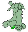
Swansea shown within Wales
In the United Kingdom, the term listed building refers to a building or other structure officially designated as being of special architectural, historical, or cultural significance; Grade II* structures are those considered to be "particularly important buildings of more than special interest".[1] Listing was begun by a provision in the Town and Country Planning Act 1947. Once listed, strict limitations are imposed on the modifications allowed to a building's structure or fittings. In Wales, the authority for listing under the Planning (Listed Buildings and Conservation Areas) Act 1990[2] rests with Cadw.
Buildings
| Name | Location | Date Listed | Grid Ref.[note 1] Geo-coordinates |
Function | Notes | HB No[note 2] | Image |
|---|---|---|---|---|---|---|---|
| Felindre water mill | Felindre | 12 April 1989 | SN6374802732 51°42′24″N 3°58′24″W / 51.70675°N 3.97330°W |
Water Mill | Situated in centre of Felindre, a substantially complete early 19th century corn mill, with intact machinery and workshop buildings. | 11210 | 
|
| Church of St Teilo, Bishopston | Bishopston | 6 March 1964 | SS5779389360 51°35′06″N 4°03′14″W / 51.58511°N 4.05398°W |
Church | Situated in a large rectangular churchyard which slopes down to the Bishopston Valley towards the W and is surrounded by trees. | 11520 | 
|
| Church of St Illtyd, Ilston | Ilston | 6 March 1964 | SS5566290327 51°35′36″N 4°05′06″W / 51.59326°N 4.08512°W |
Church | In the village of Ilston, east of the stream, reached by a footbridge. Rubble graveyard wall without coping, opened at south to extension graveyard. Oak gate with adjacent stile at main entrance, two other gates. Low retaining wall to yew tree mound. | 11524 | 
|
| Church of St Cenydd, Llangennith | Llangennith | 6 March 1964 | SS4286791416 51°35′59″N 4°16′13″W / 51.59961°N 4.27017°W |
Church | In the village of Llangennith. Stone churchyard wall; war memorial NE of churchyard is a white marble Celtic cross with interlacing on face. Early C20 timber-framed lychgate to N. To the S is the site of the ancient College of Llangennith. | 11527 | 
|
| Parish Church of St Rhidian and St Illtyd, Llanrhidian | Llanrhidian Lower | 6 March 1964 | SS4967492250 51°36′32″N 4°10′20″W / 51.60897°N 4.17232°W |
Parish church | At the centre of Llanrhidian village, surrounded by a rubble limestone churchyard wall with C19 wrought iron gates and three stiles. Macadam path, cobbles at porch. | 11533 | 
|
| Penrice Towers gatehouse | Ilston | 6 March 1964 | SS5016988383 51°34′28″N 4°09′49″W / 51.57435°N 4.16352°W |
Gatehouse | At the main entrance to Penrice Castle park, forming a picturesque focal point where the road to Port Eynon is diverted to the north of the park. The gatelodge (Penrice Towers) is to the north of the gates. (Detached south turret separately listed) | 11535 | 
|
| Church of St Illtyd | Penrice | 6 March 1964 | SS5042286123 51°33′15″N 4°09′32″W / 51.55412°N 4.15891°W |
Church | 1km from Oxwich village, on a site overlooking Oxwich Bay and reached by the coast footpath. Square churchyard with a stone wall; modern gate. | 11536 | 
|
| Kilvrough Manor | Pennard | 6 March 1964 | SS5591089316 51°35′03″N 4°04′52″W / 51.58424°N 4.08112°W |
House | Approximately 0.8km NNW of Pennard church, on the S side and reached by a short drive off the A4118 E of Parkmill. | 11538 | 
|
| Pennard Castle | Pennard | 6 March 1964 | SS5440288507 51°34′36″N 4°06′09″W / 51.57658°N 4.10254°W |
Castle | Dramatically sited on the cliff overlooking Pennard Pill and Threecliff Bay and on the W edge of Pennard golf course. | 11539 | 
|
| Church of St Andrew, Penrice | Penrice | 6 March 1964 | SS4930787939 51°34′13″N 4°10′33″W / 51.57014°N 4.17576°W |
Church | In the hamlet of Penrice, 1km SW of Penrice Castle. Churchyard wall in rubble limestone with irregular coping, two stiles, iron gate. | 11542 | 
|
| Penrice Castle (Ruins) | Penrice | 6 March 1964 | SS4966988492 51°34′31″N 4°10′15″W / 51.57520°N 4.17078°W |
Castle (ruin) | Hilltop position in parkland of Penrice Castle mansion 300m south of the A4118. The mansion itself is Grade I listed. | 11543 | 
|
| Pitt Farmhouse | Penrice | 6 March 1964 | SS4928487089 51°33′45″N 4°10′33″W / 51.56249°N 4.17573°W |
Farmhouse | At roadside, about 1km south of Penrice church. Small walled enclosure to north, separate to farmyard; gardens to south. Outbuildings in the north enclosure. | 11545 | 
|
| Church of St Mary, Rhossili | Rhossili | 6 March 1964 | SS4166488080 51°34′09″N 4°17′10″W / 51.56930°N 4.28602°W |
Church | At the centre of Rhossili village. Stone churchyard wall in rubble masonry with some older gravestones built into rear face; timber gates E and W, stile beside E gate. | 11547 | 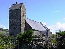
|
| Morgans Hotel | City centre | 30 March 1987 (as Offices of Associated British Ports) |
SS6599992878 51°37′07″N 3°56′13″W / 51.61874°N 3.93696°W |
Hotel | 11548 | 
| |
| Glynn Vivian Art Gallery | City centre | 30 March 1987 | SS6550393463 51°37′26″N 3°56′40″W / 51.62388°N 3.94434°W |
Art Gallery | 11553 | 
| |
| Bethesda Baptist Church, Swansea | City centre | 30 March 1987 | SS6578393897 51°37′40″N 3°56′26″W / 51.62785°N 3.94047°W |
Set below road level in a railed burial ground on the corner with Prince of Wales Road. | 11554 | .JPG)
| |
| Varsity | City centre | 30 March 1987 (as Midland Bank) |
SS6569092997 51°37′11″N 3°56′29″W / 51.61974°N 3.94146°W |
Bank | Occupying a substantial corner site, St Mary's Street to left side. | 11570 | .JPG)
|
| Ebenezer Baptist Chapel, Swansea | City centre | 30 March 1987 | SS6565393693 51°37′34″N 3°56′32″W / 51.62598°N 3.94227°W |
Chapel | 11574 | .JPG)
| |
| Ebenezer Baptist Chapel Hall | City centre | 30 March 1987 | SS6565293682 51°37′33″N 3°56′32″W / 51.62588°N 3.94227°W |
Chapel Hall | 11575 | .JPG)
| |
| Mount Pleasant Baptist Church, Swansea | City centre | 30 March 1987 | SS6541693176 51°37′17″N 3°56′44″W / 51.62128°N 3.94549°W |
Church | 11590 | 
| |
| Mount Pleasant Baptist Church Hall | City centre | 30 March 1987 | SS6542693184 51°37′17″N 3°56′43″W / 51.62135°N 3.94535°W |
Church hall | 11591 | .JPG)
| |
| Mount Pleasant Baptist School blocks | City centre | 30 March 1987 | SS6542193180 51°37′17″N 3°56′44″W / 51.62132°N 3.94542°W |
School | 11592 | .JPG)
| |
| Dylan Thomas Centre | City centre | 30 March 1987 (as The Old Guildhall) |
SS6607992929 51°37′09″N 3°56′09″W / 51.61922°N 3.93582°W |
Arts centre | 11643 | 
| |
| Swansea Museum | City centre | 23 April 1952 | SS6591892768 51°37′04″N 3°56′17″W / 51.61773°N 3.93808°W |
Museum | 11653 | 
| |
| Swansea Museum boundary walls and rails | City centre | 23 April 1952 | SS6590092795 51°37′05″N 3°56′18″W / 51.61797°N 3.93836°W |
Museum walls/railings | 11654 | 
| |
| Musgrave engine house and chimney | Landore | 1 March 1980 | SS6617994957 51°38′15″N 3°56′07″W / 51.63747°N 3.93515°W |
Engine House | Located at the southern part of the former Hafod and Morfa copperworks site, it was built in 1910 to house a uniflow-type steam engine to power the copper-rolling mill. Pistons, flywheel and rollers are all still in place, in the derelict building. Production ceased in 1980. | 11697 | 
|
| New Siloh Congregational Chapel, including gates and railings | Landore | 30 March 1987 | SS6569795712 51°38′39″N 3°56′33″W / 51.64414°N 3.94241°W |
Chapel | Occupying a prominent corner position at the top of Siloh Hill, long flank elevation to Pentre Treharn Road; ground falls steeply to E. | 11703 | .jpg)
|
| Mumbles Lighthouse | Mumbles | 24 June 1986 | SS6348187167 51°34′01″N 3°58′16″W / 51.56682°N 3.97108°W |
Lighthouse | Situated on an exposed rocky tidal islet at Mumbles Head. | 11721 | 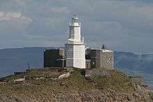
|
| Clyne Castle | Mumbles | 20 October 1994 | SS6139990630 51°35′51″N 4°00′09″W / 51.59743°N 4.00247°W |
Castle | Approx. 600m from junction with Mumbles Road. | 14931 | .jpg)
|
| Stouthall | Reynoldston | 20 July 1973 | SS4747289255 51°34′53″N 4°12′10″W / 51.58146°N 4.20279°W |
House | At north side of the B4118 1km west of Little Reynoldston, standing in parkland. | 19870 |
|
| Capel Gellionnen | Mawr | 11 October 1977 | SN7007004150 51°43′16″N 3°52′57″W / 51.72099°N 3.88239°W |
Chapel | Situated in a remote rural position high on Mynydd Gellionen reached down a track off the minor road from Rhyd-y-gwin. | 22087 | 
|
| Hendrefoilan House | Killay | 29 September 1999 | SS6128693646 51°37′28″N 4°00′19″W / 51.62450°N 4.00529°W |
Located at the end of a lane which leads off the road through the Hendrefoilan student village. The village was built in the grounds of the house. The stable block, now converted to a library, is to the NW. | 22370 | 
| |
| Penrice Castle Dovecote | Penrice | 29 October 1999 | SS4973488476 51°34′30″N 4°10′11″W / 51.57507°N 4.16984°W |
Dovecote | Attached to the west side of Penrice Castle (ruins). | 22539 |
|
| Church of St David, Port Eynon | Port Eynon | 6 March 1964 | SS4600589053 51°34′45″N 4°13′26″W / 51.57925°N 4.22386°W |
Church | In a nearly square graveyard in the farm hamlet of Llanddewi, 4km north of Port Eynon village. Rubble limestone and sandstone graveyard wall with iron gate to south; two stiles. | 22793 | 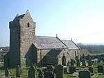
|
| Whiteford Lighthouse | Llangennith, Llanmadoc and Cheriton | 3 March 2000 | SS4437497261 51°39′09″N 4°15′04″W / 51.65254°N 4.25103°W |
Lighthouse | On a shingle bank to the south of the entrance to Burry River, and to the north of Whiteford Sands, 4 km north of Llanmadoc village | 22885 | 
|
| Church of St Nicholas, Ilston | Ilston | 19 July 2000 | SS5124988427 51°34′30″N 4°08′53″W / 51.57504°N 4.14797°W |
Church | At the south side of the road from Penmaen to Penrice. Square chuchyard with gate and stile at the north-west corner. | 23538 | 
|
| Penrice Castle North-East Gates, Railings and Piers | Ilston | 19 July 2000 | SS5018088367 51°34′27″N 4°09′48″W / 51.57421°N 4.16336°W |
Castle gates/railings | At the main entrance to Penrice Castle park, where the road from Swansea to Port Eynon is diverted to the north of the park. | 23541 |
|
| Outlying tower designed to complement Penrice Towers | Ilston | 19 July 2000 | SS5019488354 51°34′27″N 4°09′47″W / 51.57410°N 4.16315°W |
Tower | To the south east of the main gates to Penrice park, built into the park boundary wall. | 23550 |
|
| Church of St David and St Cyfelach, Llangyfelach | Llangyfelach | 28 February 2002 | SS6461098970 51°40′23″N 3°57′34″W / 51.67315°N 3.95937°W |
Church | Situated near the centre of Llangyfelach just W of the B4489 (Swansea Road) and S of the A48. | 26235 | 
|
| Tower of Church of St David and St Cyfelach, Llangyfelach | Llangyfelach | 28 February 2002 | SS6463398934 51°40′22″N 3°57′32″W / 51.67283°N 3.95902°W |
Church | Situated just S of the church in the churchyard near the centre of Llangyfelach. | 26236 | 
|
| The Equatorial Observatory, Penllergare | Penllergaer | 30 April 2002 | SS6226099094 51°40′25″N 3°59′36″W / 51.67369°N 3.99338°W |
Observatory | Situated some 60m NW of the Neath Port Talbot Borough Council offices in Penbwl Wood. | 26500 | 
|
| Scott's Pit Engine House | Birchgrove | 9 October 2003 | SS6972098300 51°40′06″N 3°53′07″W / 51.66834°N 3.88526°W |
Engine House | Situated between Llansamlet and Heol-las just NE of the M4 motorway. | 81848 | .jpg) |
See also
Notes
- ↑ Sometimes known as OSGB36, the grid reference is based on the British national grid reference system used by the Ordnance Survey.
- ↑ The "HB Number" is a unique number assigned to each listed building by Cadw.
References
- ↑ "Buildings & Conservation Areas". Cadw. Retrieved 18 June 2013.
- ↑ "Planning (Listed Buildings and Conservation Areas) Act 1990". The National Archives. Retrieved 18 June 2013.
External links
![]() Media related to Grade II* listed buildings in Swansea at Wikimedia Commons
Media related to Grade II* listed buildings in Swansea at Wikimedia Commons
| City and County of Swansea | |
|---|---|
This article is issued from Wikipedia - version of the 2/24/2016. The text is available under the Creative Commons Attribution/Share Alike but additional terms may apply for the media files.