Gold Coast Highway
| Gold Coast Highway | |
|---|---|
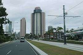 | |
| Gold Coast Highway at Second Avenue looking north towards Surfers Paradise, featuring the Light Rail in the median | |
| General information | |
| Type | Highway |
| Length | 39.5 km (25 mi) |
| Route number(s) |
|
| Former route number |
|
| Major junctions | |
| North end |
|
| South end | |
| Location(s) | |
| Major suburbs | Southport, Surfers Paradise, Broadbeach, Burleigh Heads |
| Highway system | |
|
Highways in Australia National Highway • Freeways in Australia | |
| |
The Gold Coast Highway in Queensland, Australia links the coastal suburbs of the Gold Coast. 35 kilometres (22 mi) in length, the highway runs from the Pacific Motorway at Helensvale to the Pacific Motorway at Tweed Heads. It passes through the numerous popular tourist areas including Surfers Paradise and Broadbeach, a commercial centre at Southport, residential areas, shopping centres and the Gold Coast (Coolangatta) Airport.
It is characterised by a variety of urban landscapes, ranging from:
- high-density high rises between Southport and Broadbeach
- low rise apartments in Palm Beach and Bilinga
- low-rise residential areas at Miami, Tugun and Labrador
- shopping at Southport and Broadbeach
- entertainment precincts at Broadbeach and Surfers Paradise
- historic motels at Mermaid Beach
- light industry at Arundel
- native bushland at Coombabah Lake wetlands, Burleigh Head National Park and Currumbin Hill
- parklands, sport and recreation at the Southport Broadwater Parklands and many smaller reserves
- coastal views at Currumbin Creek
The highest point of the highway is 42 metres at Currumbin Hill.[1]
History
It was formerly part of the Pacific Highway, when it handled transport between Queensland and New South Wales through the Gold Coast. The Pacific Highway now runs about 8 kilometres (5.0 mi) to the west as the M1.
Road conditions

The highway is divided along the entire length, mostly with four lanes. There are some six lane segments (often as bus lanes). It is also predominately well lit at night, with a few exceptions such as Currumbin and Burleigh Heads. Median fencing to prevent pedestrians crossing has also been introduced in areas such as Mermaid Beach. The highway at Surfers Paradise is subject to congestion during events, notably during the Gold Coast 600 held each October when part of the highway becomes part of the Surfers Paradise Street Circuit at Paradise Waters. The highway width is reduced to two lanes (one carriageway) and the speed limit reduced to 40 km/h.
Speed limits
- Helensvale to Captain Cook Drive (Arundel): 80 km/h
- Captain Cook Drive to Government Road (Labrador): 70 km/h
- Government Road to Nerang St (Southport): 60 km/h
- Nerang St to Ferny Ave (Surfers Paradise): 70 km/h
- Ferny Ave to Pacific Ave (Miami): 60 km/h
- Pacific Ave to West Burleigh Rd: 70 km/h
- West Burleigh Rd to George St East(Burleigh Heads): 50 km/h
- George St East to Tallebudgera Dr (Palm Beach): 60 km/h
- Tallebudgera Dr to Eighth Ave (Palm Beach): 70 km/h
- Eighth Ave to Thrower Drive (Palm Beach): 60 km/h
- Thrower Drive to Toolona St (Tugun): 70 km/h
- Toolona St to Pacific Hwy: 80 km/h
Projects and improvements
1. Labrador: Between Government Road and North Street, along a section mostly called Frank Street. The Highway was upgraded from a single carriageway to a divided 4 lane highway. A new bridge with a 4 lane crossing has been completed across Loders Creek in 2007. The road upgrade resulted in a thoroughfare similar to that in Surfers Paradise, with a narrow median and narrow road reserve due to limited space and to minimise property resumptions. One of the two lanes in each direction was initially designated a transit lane (buses and vehicles with 2 or more occupants), but this designation was removed in 2013.[2]

2. Broadbeach to Miami: Bus lanes will be added along the route as well as changes to bus stops, u-turns, traffic lights, signs, lighting and the median strip. The first phase (Alexandra Avenue to Hilda Street) was finished in mid September 2008. The second phase (Hilda Street to Chairlift Avenue) was largely completed in July 2009.[3]
3. Tugun: The most notorious bottle-neck was at Tugun, where the Gold Coast Highway joins the Pacific Highway 8 kilometres (5.0 mi) north of Coolangatta has been eliminated with the opening of the Tugun Bypass in June 2008. Some minor changes and improvements near Stewart Road in Tugun have coincided with the completion of the bypass to deal with the changed traffic flow.
Public transport
Bus
Bus services throughout the area are operated by Surfside Buslines. Route 700 operates along the highway between Broadbeach South and Tweed Heads. On Sunday to Thursday nights it continues north of Broadbeach South to the Gold Coast University Hospital. It is the only 24-hour bus route in Australia. It is complemented by limited stops route 777 from Broadbeach South to Gold Coast Airport.[4][5]
Bus Lanes are in place along some sections of the highway, particularly Broadbeach to Mermaid Beach and Miami.
Light Rail
The G:link light rail line opened in July 2014 between Gold Coast University Hospital and Broadbeach South. It has its own reservation to the west of the Gold Coast Highway from Southport to Surfers Paradise, from where it diverges onto Surfers Paradise Boulevard. It then rejoins the Gold Coast Highway at the south end of Surfers Paradise proceeding via a reservation in the median strip to Broadbeach North before crossing again to the western side to terminate at Broadbeach South. It is to be extended to Helensvale by 2018.[6]
Railway
Helensvale railway station is located near the northern end of the highway. It is on the Gold Coast railway line with services operating frequently along the electrified line between Brisbane and Varsity Lakes.
Air
Gold Coast Airport is located at the southern end of the highway. It has frequent flights to Sydney and Melbourne as well as international services to New Zealand, Japan and South-East Asia.
See also
References
| Wikimedia Commons has media related to Gold Coast Highway. |
- ↑ "Track". Gold Coast Highway. GPSies. Retrieved 2 March 2014.
- ↑ "Gold Coast Highway - Government Road to North Street". Road Projects. Queensland Government Department of Main Roads. 2007-10-29. Retrieved 2007-12-17.
- ↑ "Gold Coast Highway upgrade and bus lanes - Broadbeach to Miami". Road Projects. Queensland Government Department of Main Roads. 2007-10-29. Retrieved 2007-12-17.
- ↑ Route 700 timetable TransLink 21 July 2014
- ↑ Route 777 timetable TransLink 21 July 2014
- ↑ Stephens, Kim (11 October 2015). "Gold Coast light rail: PM arrives by train with $95m promise on board". Brisbane Times.
External links
| Motorways: | ||
|---|---|---|
| Highways: | ||
| Major roads: |
| |