Burnett Highway
| Burnett Highway Queensland | |
|---|---|
 | |
| Burnett Highway (green on black) | |
| General information | |
| Type | Highway |
| Length | 542 km (337 mi) |
| Route number(s) |
|
| Former route number |
|
| Major junctions | |
| North end |
|
|
| |
| South end |
|
| Location(s) | |
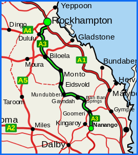
| Major settlements | Mt. Morgan, Dululu, Biloela, Monto, Eidsvold, Mundubbera, Gayndah, Ban Ban Springs, Goomeri |
| Highway system | |
|
Highways in Australia National Highway • Freeways in Australia Highways in Queensland | |
| |
The Burnett Highway is an inland rural highway located in Queensland, Australia. The highway runs between its junction with the Bruce Highway just south of Rockhampton, and Nanango. Its length is approximately 542 kilometres. The highway takes its name from the Burnett River, which it crosses a number of times. The Burnett Highway provides the most direct link between the northern end of the New England Highway and Rockhampton. It is designated as a State Strategic Road by the Queensland Government.[1]
Route description
List of towns on the Burnett Highway
From north to south
- Bouldercombe
- Mount Morgan
- Dululu
- Jambin
- Biloela
- Thangool
- Monto
- Eidsvold
- Mundubbera
- Gayndah
- Ban Ban Springs
- Goomeri
- Nanango
Gallery
-
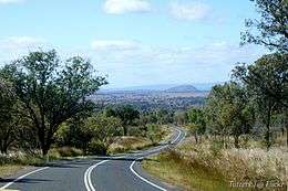
Burnett Highway near Binjour
History
In January 2013, Cyclone Oswald caused flood damage to the road and a partial closure, which took longer than a year to repair.[2]
Major intersections
| LGA | Location | km | mi | Destinations | Notes |
|---|---|---|---|---|---|
| Rockhampton | Gracemere | 0 | 0.0 | south - Mount Larcom | Northern end of Burnett Highway. |
| Banana | Dululu | 63.1 | 39.2 | south-west - Wowan | |
| Biloela | 135.1 | 83.9 | east - Calliope | North-western concurrency terminus with Dawson Highway | |
| 136.3 | 84.7 | east - Calliope | South-eastern concurrency terminus with Dawson Highway | ||
| North Burnett | Mundubbera | 338.3 | 210.2 | ||
| Burnett River | 381.3 | 236.9 | Les Baker Bridge | ||
| North Burnett | Ban Ban Springs | 408.1 | 253.6 | ||
| Gympie | Goomeri | 482.3 | 299.7 | Northern concurrency terminus with State Route 49 | |
| 484.1 | 300.8 | Southern concurrency terminus with State Route 49 | |||
| South Burnett | Nanango | 542.3 | 337.0 | (State Route 96) north-west - Kingaroy | Southern end of Burnett Highway. |
1.000 mi = 1.609 km; 1.000 km = 0.621 mi
| |||||
See also
References
- ↑ Queensland Government - Department of Transport and Main Roads - Maps
- ↑ Austin King (12 Apr 2014). "Burnett Hwy still closed more than a year after landslide". The Morning Bulletin. Capricornia Newspapers. Retrieved 29 July 2014.
This article is issued from Wikipedia - version of the 7/13/2016. The text is available under the Creative Commons Attribution/Share Alike but additional terms may apply for the media files.