Gilmore Township, Greene County, Pennsylvania
| Gilmore Township | |
|---|---|
| Township | |
|
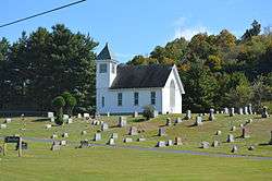
Pine Bank Methodist Church on Toms Run Road | |
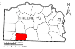 Location of Gilmore Township in Greene County | |
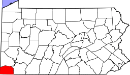 Location of Greene County in Pennsylvania | |
| Country | United States |
| State | Pennsylvania |
| County | Greene |
| Area | |
| • Total | 21.7 sq mi (56 km2) |
| Population (2000) | |
| • Total | 295 |
| • Density | 14/sq mi (5.2/km2) |
| Time zone | EST (UTC-4) |
| • Summer (DST) | EDT (UTC-5) |
| Area code(s) | 724 |
Gilmore Township is a township in Greene County, Pennsylvania, United States. The population was 295 at the 2000 census.
Geography
According to the United States Census Bureau, the township has a total area of 21.7 square miles (56 km2), all of it land.
Demographics
As of the census[1] of 2000, there were 295 people, 114 households, and 79 families residing in the township. The population density was 13.6 people per square mile (5.3/km²). There were 153 housing units at an average density of 7.1/sq mi (2.7/km²). The racial makeup of the township was 99.66% White, and 0.34% from two or more races.
There were 114 households, out of which 35.1% had children under the age of 18 living with them, 62.3% were married couples living together, 5.3% had a female householder with no husband present, and 30.7% were non-families. 28.1% of all households were made up of individuals, and 14.0% had someone living alone who was 65 years of age or older. The average household size was 2.59 and the average family size was 3.16.
In the township the population was spread out, with 28.1% under the age of 18, 7.5% from 18 to 24, 27.1% from 25 to 44, 25.8% from 45 to 64, and 11.5% who were 65 years of age or older. The median age was 36 years. For every 100 females there were 103.4 males. For every 100 females age 18 and over, there were 92.7 males.
The median income for a household in the township was $35,208, and the median income for a family was $46,250. Males had a median income of $41,458 versus $26,250 for females. The per capita income for the township was $16,325. About 7.8% of families and 14.8% of the population were below the poverty line, including 19.1% of those under the age of 18 and 11.8% of those 65 or over.
References
- ↑ "American FactFinder". United States Census Bureau. Retrieved 2008-01-31.
Municipalities and communities of Greene County, Pennsylvania, United States | ||
|---|---|---|
| Boroughs | | |
| Townships | ||
| CDPs | ||
| Unincorporated communities | ||
Coordinates: 39°44′00″N 80°19′59″W / 39.73333°N 80.33306°W