Furnace Village Historic District
|
Furnace Village Historic District | |
|
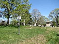
Furnace Village Cemetery | |
  | |
| Location | Easton, Massachusetts |
|---|---|
| Coordinates | 42°1′24″N 71°7′57″W / 42.02333°N 71.13250°WCoordinates: 42°1′24″N 71°7′57″W / 42.02333°N 71.13250°W |
| Built | 1751 |
| Architect | Multiple |
| Architectural style | Greek Revival, Federal |
| NRHP Reference # | [1] |
| Added to NRHP | October 6, 1983 |
The Furnace Village Historic District is a historic district encompassing a historic colonial industrial area in Easton, Massachusetts. It is centered on the junction of Foundry Street (Massachusetts Routes 106 and 123) with South Street and Poquanticut Avenue. The area was settled in 1723, with industrial activity beginning in 1742. An iron furnace was established here in 1751, and industrial uses continued into the 19th century. In addition to colonial-era houses, there are also 19th-century worker housing units.[2]
The district was listed on the National Register of Historic Places in 1983.[1]
See also
References
- 1 2 National Park Service (2008-04-15). "National Register Information System". National Register of Historic Places. National Park Service.
- ↑ "MACRIS inventory record for Furnace Village Historic District". Commonwealth of Massachusetts. Retrieved 2014-06-14.
| Topics |  | ||||||||||||||||||||||||||||||
|---|---|---|---|---|---|---|---|---|---|---|---|---|---|---|---|---|---|---|---|---|---|---|---|---|---|---|---|---|---|---|---|
| Lists by county | |||||||||||||||||||||||||||||||
| Lists by city |
| ||||||||||||||||||||||||||||||
| Other lists | |||||||||||||||||||||||||||||||
| |||||||||||||||||||||||||||||||
This article is issued from Wikipedia - version of the 11/27/2016. The text is available under the Creative Commons Attribution/Share Alike but additional terms may apply for the media files.