French River, Ontario
| French River Rivière-des-Français | |
|---|---|
| Municipality (single-tier) | |
| Municipality of French River Municipalité de Rivière-des-Français | |
|
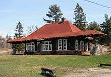
The French River at the French River Post | |
 French River | |
| Coordinates: 46°10′N 80°30′W / 46.167°N 80.500°WCoordinates: 46°10′N 80°30′W / 46.167°N 80.500°W | |
| Country |
|
| Province |
|
| District | Sudbury |
| Incorporated | 1999 |
| Government | |
| • Type | Town |
| • Mayor | Claude Bouffard |
| • Governing Body | French River Municipal Council |
| • MP | Marc Serré (Liberal) |
| • MPP | John Vanthof (NDP) |
| Area[1] | |
| • Land | 735.47 km2 (283.97 sq mi) |
| Population (2011)[1] | |
| • Total | 2,442 |
| • Density | 3.3/km2 (9/sq mi) |
| Time zone | EST (UTC-5) |
| • Summer (DST) | EDT (UTC-4) |
| Area code(s) | 705 |
| Website |
www |

French River, also known as Rivière-des-Français, is a municipality in the Canadian province of Ontario, in the Sudbury District. The municipality had a population of 2,442 in the Canada 2011 Census.[1] It was formed in 1999 through the merger of the Township of Cosby, Mason and Martland and surrounding unincorporated portions of the Unorganized North Sudbury District. It was named after the French River that flows through the municipality.
The borders of the municipality are composed of Highway 69 to the west (the French River Trading Post and French River Inn properties are also included within the municipal boundary), West Arm to the north on Highway 535 (just east of Shaw Rd.), the end of Wolseley Bay Rd to the east (Highway 528) and the community of North Monetville to the northeast.
Along with the municipalities of St. Charles, Killarney, and Markstay-Warren, it is part of the region known as Sudbury East.[2] These communities partner together on several ventures, including the Sudbury East Planning Board, Sudbury East Municipal Association, Manitoulin-Sudbury District Services Board (MSDSB) and Sudbury East Board of Trade.
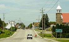
Communities
The municipality comprises the communities of Alban, Bigwood, Chartrand Corner, Delamere, French River Station, Happy Landing, Jamot, Monetville, Noëlville, North Monetville, Ouellette, Rutter, Sucker Creek Landing and Wolseley Bay.
Alban
The community of Alban was originally established in 1907 as Rutter, named for the nearby railway station in 1907, but in 1937 the community was renamed for Rev. J. Alban Filiatrault. In 1934, the Parish of Notre-Dame-de-Lourdes is created. Mr. Jean-Baptiste Rochon donates several acres of land to the habitants of Alban to erect a church. During the night of February 6, 1953, the church burns to the ground. The following Sunday, Father Oliva Campeau proposes the immediate reconstruction of the church. This time, it will be constructed with brick and the walls of plaster instead of wood. In 1984, the Notre-Dame-de-Lourdes Parish celebrates its 50th anniversary.
Monetville
Originally known as Martland, the community was first settled in 1895 by Cyrille Monette (née Boisvert) and four other pioneers. It became a municipality in 1906 and adopted the name Monetville.
For many years the Greenway Hotel was one of the few notable buildings while driving through on the highway.
Monetville is divided into two areas North Monetville and Monetville. "South" Monetville is generally from Dokis Road south to Bear Lake and Shanty Bay of Lake Nipissing. North Monetville extends generally from Dokis Road north to the West Arm of Lake Nipissing and Chapel Island which Highway 64 crosses on the West Arm. North Monetville was settled by the Douglas Family, the Mercer Family and the Purcell family in the early 1900s.
Noëlville
Noëlville, originally known as Cosby, was founded in 1905 with the arrival of settlers in the region. Noëlville families travelled by boat, to the south-west end of Lake Nipissing, to establish themselves between Lake Nipissing and the French River. To pay homage to Noël Desmarais, the village's first merchant and the first businessman of the region, the town of Cosby became Noëlville in 1911. Desmarais is the grandfather to businessman Paul Desmarais.[3] Noël Desmarais was one of the first to start his family business in Noëlville.
In 2007, Noëlville made the top five communities in CBC Television's Hockeyville competition.[4] The neighbouring city of Greater Sudbury offered its support to Noëlville, although the community ultimately lost out to another nearby city, North Bay.
North Monetville
The North Monetville area straddles the municipal boundary between French River and West Nipissing. "Created" in the 1970s to aid the delivery of supplies to the Monetville Public School which was located several kilometers north on Highway 64 from the signposts designating the town of Monetville. Sucker Creek Landing and Chapel Island are both considered to be part of North Monetville, with Highway 64 crossing Chapel Island and bridging the West Arm Narrows of Lake Nipissing at both ends of the island. Most residents of North Monetville simply state their address as "Monetville" even if they do live in the north end of the village.
The Community of Christ cemetery, 339 East Road, [5] has a Canadian World War II hero buried there. Sgt. Wallace Edmond Firlotte, who served with the Lincoln and Welland Regiment during the war, was bestowed six war decorations. Firlotte was one of only a very few Canadians that was bestowed the Order of the Bronze Lion for heroism from the Crown of the Netherlands. This award is presented for "Deeds of extreme bravery and leadership in battle favouring the Netherlands". The Prince personally presented this Order to Sgt. Firlotte by Royal Decree on December 8, 1945.
Community events
Each February, Noëlville hosts the largest and longest running family hockey tournament in Canada. Five years after the Noëlville Community Centre was built in 1972, the Noëlville Family Hockey Tournament was founded in 1977 by Claude Mayer, Gerry Gratton, and Dan Pitre. There were 17 teams. The first game was played on New Year's night when the Carrière family played against the Mayer family. The Pitre family won the inaugural tournament. This tournament survives to this day and has become a much anticipated event in this small town where families reunite when friends and members of the extended family return 'home' to compete in this event which now hosts between 32 and 36 teams and families every year. Over the years, this tournament raised over $150,000 for local charities.
In August, the Club Richelieu Rivière-des-Français hosts the family softball tournament, which regularly hosts over 100 teams and provides numerous economic benefits to the region. August 5th-6th-7th, 2016 was the 32nd year of this tournament and had 103 teams registered. Over the years, this tournament has raised over $221,330 to help fund various cultural, educational and community activities.
Government
The municipal office is located at 44 St Christophe St in Noelville. The council is composed of the mayor and six councillors. The current mayor is Claude Bouffard, who defeated Harold Duff and Collin Bourgeois in the 2010 municipal election with 44.8% of the vote.
French River utilizes the mail-in balloting system for municipal elections rather than polling stations. Voter turnout in the 2010 elections was 62%.[6]
The 2012 operating budget for French River was approximately $8 million, and the municipality employs approximately 30 staff, plus 50 volunteer firefighters.
Demographics
| Canada census – French River, Ontario community profile | |||
|---|---|---|---|
| 2011 | 2006 | 2001 | |
| Population: | 2442 (-8.2% from 2006) | 2659 (-5.4% from 2001) | 2810 (-1.3% from 1996) |
| Land area: | 735.47 km2 (283.97 sq mi) | 734.26 km2 (283.50 sq mi) | 734.15 km2 (283.46 sq mi) |
| Population density: | 3.3/km2 (8.5/sq mi) | 3.6/km2 (9.3/sq mi) | 3.8/km2 (9.8/sq mi) |
| Median age: | 53.7 (M: 53.8, F: 53.7) | 50.1 (M: 50.4, F: 49.9) | 46.2 (M: 46.2, F: 46.1) |
| Total private dwellings: | 1833 | 2053 | 2109 |
| Median household income: | $43,739 | $36,461 | |
| References: 2011[7] 2006[8] 2001[9] | |||
Population trend:[10]
- Population in 2011: 2442
- Population in 2006: 2659
- Population in 2001: 2810
- Population in 1996: 2847
Median age of the population:
- 53.7 years
Ethnicity:
- 88.4% White
- 10.3% Métis
- 1.3% First Nations
Language most often spoken at home:
- 60.8% English
- 38.4% French
- 0.8% Other
Media
The French River area is served by radio and television stations from the Sudbury, North Bay and Parry Sound areas. On December 9, 2013, Justin Godin, on behalf of a corporation to be incorporated submitted an application to operate a new low-power English language commercial variety radio station to serve the French River area. Godin's application was approved on May 21, 2014. The new station, CKUC-FM will operate on 102.7 MHz with an effective radiated power of 42 watts and would be a first local radio station to serve the French River area.[11]
See also
References
- 1 2 3 2011 Census Profile
- ↑ Sudbury East Planning Board.
- ↑ http://www.thecanadianencyclopedia.com/articles/paul-desmarais
- ↑ "Noelville makes final five in CBC Hockeyville contest". Northern Life, March 12, 2007.
- ↑ Community of Christ Cemetery records
- ↑ http://www.frenchriver.ca/_assets/2010%20Election%20Results%20Stats.pdf
- ↑ "2011 Community Profiles". Canada 2011 Census. Statistics Canada. July 5, 2013. Retrieved 2012-02-14.
- ↑ "2006 Community Profiles". Canada 2006 Census. Statistics Canada. March 30, 2011. Retrieved 2011-04-11.
- ↑ "2001 Community Profiles". Canada 2001 Census. Statistics Canada. February 17, 2012. Retrieved 2011-04-11.
- ↑ Statistics Canada: 1996, 2001, 2006, 2011 census
- ↑ Broadcasting Notice of Consultation CRTC 2013-663, Notice of hearing, CRTC, December 9, 2013
External links
| Wikivoyage has a travel guide for French River. |
| Wikimedia Commons has media related to French River, Ontario. |
 |
St. Charles | West Nipissing | | |
| Unorganized North Sudbury | |
Dokis 9 | ||
| ||||
| | ||||
| Killarney | French River Unorganized Centre Parry Sound, French River 13 |
| Towns | 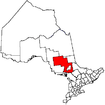 | |
|---|---|---|
| Townships | ||
| First Nations | ||
| Indian reserves | ||
| Unorganized area | ||
| Local services boards | ||
| ||