Fort Banks Mortar Battery
|
Fort Banks Mortar Battery | |
|
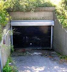
Fort Banks, Mortar Pit B, 2009 | |
  | |
| Location | Kennedy Dr., Winthrop, Massachusetts |
|---|---|
| Coordinates | 42°23′3.5″N 70°58′49″W / 42.384306°N 70.98028°WCoordinates: 42°23′3.5″N 70°58′49″W / 42.384306°N 70.98028°W |
| Area | 2.7 acres (1.1 ha) |
| Built | 1892 |
| Architect | Abbot, Col. Henry; Mansfield, Lt. Col. Samuel L., etal |
| NRHP Reference # | 07000144[1] |
| Added to NRHP | March 12, 2007 |


Fort Banks Mortar Battery is a historic mortar battery on Kennedy Drive in Winthrop, Massachusetts that was part of the old Fort Banks. It was originally built in 1892 and named for the Civil War general and congressman Nathaniel P. Banks[2] It consisted of four concrete pits, arranged in a square, each of which had four 12-inch (305 mm) mortars which could throw an 800 pound (350 kg) shell 9 miles (14 km) to sea.[2][3] The combination was known as an Abbott Quad. Because a mortar throws a shell in a very high arc, they could be mounted in pits, invisible to the ship which was the target, and therefore very hard for an attacker to silence. The powder charge, which was a bag loaded separately from the shell, weighed 65 pounds (30 kg).[3]
There was a serious accident on the site on October 15, 1904, when, during practice, a charge went off without the breech of the mortar being fully closed. Four men were killed and nine others were seriously injured.[3]
Later, anti-aircraft guns were added and the Fort became the base for the Army's 9th Artillery Regiment. It also had a 250-bed hospital. In the 1950s Nike anti-aircraft missiles were based on the site.[2]
Of the four pits, only one, Mortar Pit B, remains, together with two underground bunkers leading off the pit. It was added to the National Register of Historic Places in 2007.
It is currently located in the middle of a residential neighborhood.
See also
References
- ↑ National Park Service (2009-03-13). "National Register Information System". National Register of Historic Places. National Park Service.
- 1 2 3 Plaque on site provided by Winthrop Historical Commission. Photographed 19-Oct-2009
- 1 2 3 Plaque on site provided by Fort Banks Preservation Association. Photographed 19-Oct-2009
| Wikimedia Commons has media related to Fort Banks. |
| Topics |  | ||||||||||||||||||||||||||||||
|---|---|---|---|---|---|---|---|---|---|---|---|---|---|---|---|---|---|---|---|---|---|---|---|---|---|---|---|---|---|---|---|
| Lists by county | |||||||||||||||||||||||||||||||
| Lists by city |
| ||||||||||||||||||||||||||||||
| Other lists | |||||||||||||||||||||||||||||||
| |||||||||||||||||||||||||||||||