Excursion Inlet, Alaska
| Excursion Inlet, Alaska | |
|---|---|
| CDP | |
|
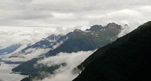
Excursion Inlet as viewed from the air | |
 Location of Excursion Inlet, Alaska | |
| Coordinates: 58°24′41″N 135°24′31″W / 58.41139°N 135.40861°W | |
| Country | United States |
| State | Alaska |
| Borough | Haines |
| Government | |
| • Borough mayor | Janice Hill[1] |
| • State senator | Dennis Egan (D) |
| • State rep. | Sam Kito III (D) |
| Area | |
| • Total | 56.9 sq mi (147.4 km2) |
| • Land | 56.8 sq mi (147 km2) |
| • Water | 0.1 sq mi (0.4 km2) |
| Elevation | 79 ft (24 m) |
| Population (2000) | |
| • Total | 10 |
| Time zone | Alaska (AKST) (UTC-9) |
| • Summer (DST) | AKDT (UTC-8) |
| Area code(s) | 907 |
| FIPS code | 02-23900 |
| GNIS feature ID | 1865551 |
Excursion Inlet is a census-designated place (CDP) in Haines Borough in the U.S. state of Alaska. The population was 10 at the 2000 census.
Geography
Excursion Inlet is located at 58°24′41″N 135°24′31″W / 58.41139°N 135.40861°W (58.411303, -135.408740).[2]
According to the United States Census Bureau, the CDP has a total area of 56.9 square miles (147 km2), of which, 56.8 square miles (147 km2) of it is land and 0.2 square miles (0.52 km2) of it (0.26%) is water.
Demographics
As of the census[3] of 2000, there were 10 people, 8 households, and 2 families residing in the CDP. The population density was 0.2 people per square mile (0.1/km²). There were 85 housing units at an average density of 1.5/sq mi (0.6/km²). The racial makeup of the CDP was 100.00% White.
There were 8 households out of which none had children under the age of 18 living with them, 25.0% were married couples living together, and 75.0% were non-families. 75.0% of all households were made up of individuals and 12.5% had someone living alone who was 65 years of age or older. The average household size was 1.25 and the average family size was 2.00.
In the CDP the population was spread out with 30.0% from 25 to 44, 20.0% from 45 to 64, and 50.0% who were 65 years of age or older. The median age was 60 years. For every 100 females there were 400.0 males. For every 100 females age 18 and over, there were 400.0 males.
The median income for a household in the CDP was $16,250, and the median income for a family was $10,000. Males had a median income of $38,750 versus $0 for females. The per capita income for the CDP was $18,188. Below the poverty line were 25.0% of the population, 50.0% of families, none of those under 18 and 40.0% of those over 64.
History
Excursion Inlet was originally an Alaska Native village. Excursion Inlet has had a fishing cannery since 1891. The current plant, constructed in 1918, still functions to this day. It mostly processes pink and chum salmon, as well as salmon roe, salmon caviar, halibut and sablefish. It is located near the mouth of the inlet, about 40 miles west of Juneau. Its seasons run from late June to mid-September. Excursion Inlet Cannery is one of the largest fish canneries in the world and was acquired by Ocean Beauty Seafoods in 2003.
During the early stages of American involvement in World War II, the United States Army built a major barge terminal at Excursion Inlet. Capable of handling large ocean-going cargo ships and intended to be manned by thousands of soldiers, the terminal was built to serve as a logistics base for the Army's efforts to liberate the Aleutian Islands from their Japanese invaders. However, by the time the terminal was completed in late 1943, the Aleutian Campaign was effectively over, and the terminal had no evident future purpose. When the facility's existence became public knowledge in early 1945, newspapers decried it as a wasteful boondoggle, and the Army opted to quietly shut it down. German prisoners of war were later brought in to dismantle the base and salvage usable materials. The docks and some of the buildings were sold to the cannery and remain standing today.[4]
References
- ↑ 2015 Alaska Municipal Officials Directory. Juneau: Alaska Municipal League. 2015. p. 7.
- ↑ "US Gazetteer files: 2010, 2000, and 1990". United States Census Bureau. 2011-02-12. Retrieved 2011-04-23.
- ↑ "American FactFinder". United States Census Bureau. Retrieved 2008-01-31.
- ↑ German POWs helped dismantle SE Alaska’s ‘White Elephant’. Kiffer, Dave. SITNews, 17 February 2015
Coordinates: 58°24′41″N 135°24′31″W / 58.411303°N 135.40874°W
Municipalities and communities of Haines Borough, Alaska, United States | ||
|---|---|---|
| CDPs | 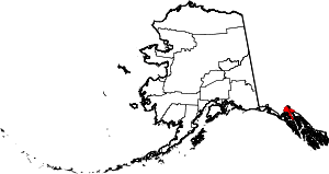 | |
| Footnotes | ‡This populated place also has portions in adjacent boroughs or census areas | |