Elmet and Rothwell (UK Parliament constituency)
Coordinates: 53°49′05″N 1°24′14″W / 53.818°N 1.404°W
| Elmet and Rothwell | |
|---|---|
|
County constituency for the House of Commons | |
|
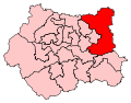
Boundary of Elmet and Rothwell in West Yorkshire. | |
|
Location of West Yorkshire within England. | |
| County | West Yorkshire |
| Electorate | 77,994 (December 2010)[1] |
| Major settlements | Rothwell, Garforth, Wetherby |
| Current constituency | |
| Created | 2010 |
| Member of parliament | Alec Shelbrooke (Conservative) |
| Number of members | One |
| Created from | Elmet, Morley and Rothwell |
| Overlaps | |
| European Parliament constituency | Yorkshire and the Humber |

Elmet and Rothwell is a constituency in West Yorkshire represented in the House of Commons of the UK Parliament since its creation in 2010 by Alec Shelbrooke, a Conservative.[n 1] In the 2015 General Election, Elmet & Rothwell recorded the largest turnout of any seat in West or South Yorkshire, with nearly 58,000 electors casting a vote.
The constituency includes rural hinterland to the east of Leeds, including the historical market town of Wetherby and former coal mining towns and villages like Garforth and Kippax. The area is undergoing a transition from old mining communities to more affluent commuter and dormitory towns for the Leeds conurbation to the west. There is no town of Elmet: the name refers to an ancient Celtic kingdom in the area.
History
Following its review of parliamentary boundaries in West Yorkshire, the Boundary Commission for England created this constituency for the 2010 election which principally contains the three towns of Garforth, Rothwell and Wetherby.
Constituency profile
Situated to the east of Leeds is the seat of Elmet and Rothwell in West Yorkshire. The constituency is named after the town of Rothwell and the ancient British Celtic kingdom of Elmet. The market town of Wetherby and the suburb communities of Garforth, Rothwell and Kippax have largely become commuter towns for Leeds.
This is mostly white, owner-occupier territory, with only one in 10 living in social housing, according to ONS 2011 Census figures for England and Wales. Considering this, below average levels of adults here claim Job Seeker's Allowance, with only 1% of constituents doing so. A quarter of the population works in retail and manufacturing; four in 10 have a professional, managerial or technical job, while one in 20 is an apprentice. 28% of constituents have a university degree or higher.
The area has below average levels of immigration. Only 4% of the constituency were born outside the UK, compared to 13% nationally.[2]'
Elmet and Rothwell ranks 206th in a list of the largest constituencies in the UK (geographical size), and 248th in a list of the largest constituencies by population size.
Boundaries
The City of Leeds wards of Garforth and Swillington, Harewood, Kippax and Methley, Rothwell, and Wetherby.
Members of Parliament
| Election | Member[3] | Party | |
|---|---|---|---|
| 2010 | Alec Shelbrooke | Conservative | |
Elections
- For results before 2010, see Elmet and Morley and Rothwell
Elections in the 2010s
| Party | Candidate | Votes | % | ± | |
|---|---|---|---|---|---|
| Conservative | Alec Shelbrooke | 27,978 | 48.4 | +5.8 | |
| Labour | Veronica King | 19,488 | 33.7 | -0.8 | |
| UKIP | Paul Spivey | 6,430 | 11.1 | +8.3 | |
| Liberal Democrat | Stewart Golton | 2,640 | 4.6 | -11.8 | |
| Green | Dave Brooks | 1,261 | 2.2 | +2.2 | |
| Majority | 8,490 | 14.7 | +6.6 | ||
| Turnout | 57,797 | 73.0 | +1.2 | ||
| Conservative hold | Swing | +3.3 | |||
This new constituency of Elmet and Rothwell was fought for the first time at the 2010 general election.
| Party | Candidate | Votes | % | ± | |
|---|---|---|---|---|---|
| Conservative | Alec Shelbrooke | 23,778 | 42.6 | +8.1 | |
| Labour | James Lewis | 19,257 | 34.5 | -11.4 | |
| Liberal Democrat | Stewart Golton | 9,109 | 16.3 | -1.0 | |
| BNP | Sam Clayton | 1,802 | 3.2 | +0.9 | |
| UKIP | Darren Oddy | 1,593 | 2.9 | +2.9 | |
| Independent | Christopher Nolan | 250 | 0.4 | +0.4 | |
| Majority | 4,521 | 8.1 | +6.6 | ||
| Turnout | 55,789 | 71.8 | +2.0 | ||
| Conservative win (new seat) | |||||
See also
Notes and references
- Notes
- ↑ Like all constituencies, the constituency elects one Member of Parliament (MP) by the first past the post system of election at least every five years.
- References
- ↑ "Electorate Figures - Boundary Commission for England". 2011 Electorate Figures. Boundary Commission for England. 4 March 2011. Retrieved 13 March 2011.
- ↑ "Elmet and Rothwell Parliamentary Profile". 2011 Electorate Figures. BBC. 8 May 2015. Retrieved 8 May 2015.
- ↑ Leigh Rayment's Historical List of MPs – Constituencies beginning with "E" (part 2)
- ↑ "Election Data 2015". Electoral Calculus. Archived from the original on 17 October 2015. Retrieved 17 October 2015.
- ↑ "Elmet & Rothwell". BBC News. Retrieved 13 May 2015.
- ↑ "Election Data 2010". Electoral Calculus. Archived from the original on 17 October 2015. Retrieved 17 October 2015.
- ↑ "UK > England > Yorkshire & the Humber > Elmet & Rothwell". Election 2010. BBC. 7 May 2010. Retrieved 12 May 2010.