Ellinwood, Kansas
| Ellinwood, Kansas | |
|---|---|
| City | |
 Location within Barton County and Kansas | |
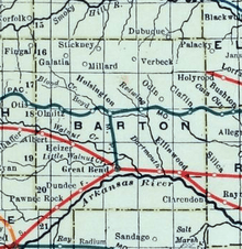
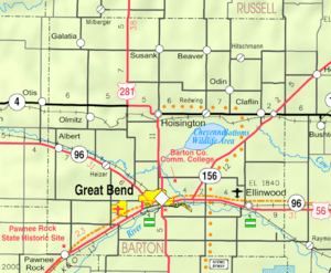 KDOT map of Barton County (legend) | |
| Coordinates: 38°21′22″N 98°34′51″W / 38.35611°N 98.58083°WCoordinates: 38°21′22″N 98°34′51″W / 38.35611°N 98.58083°W | |
| Country | United States |
| State | Kansas |
| County | Barton |
| Government | |
| • Mayor | Irlan Fullbright |
| Area[1] | |
| • Total | 1.14 sq mi (2.95 km2) |
| • Land | 1.14 sq mi (2.95 km2) |
| • Water | 0 sq mi (0 km2) |
| Elevation | 1,791 ft (546 m) |
| Population (2010)[2] | |
| • Total | 2,131 |
| • Estimate (2012[3]) | 2,120 |
| • Density | 1,900/sq mi (720/km2) |
| Time zone | Central (CST) (UTC-6) |
| • Summer (DST) | CDT (UTC-5) |
| ZIP code | 67526 |
| Area code | 620 |
| FIPS code | 20-20425 [4] |
| GNIS feature ID | 0475775 [5] |
| Website | City website |
Ellinwood is a city in the southeast corner of Barton County, Kansas, United States. As of the 2010 census, the city population was 2,131.[6]
History
19th century
For millennia, the land now known as Kansas was inhabited by Native Americans. In 1803, most of modern Kansas was secured by the United States as part of the Louisiana Purchase. In 1854, the Kansas Territory was organized, then in 1861 Kansas became the 34th U.S. state. In 1867, Barton County was founded.
The first claim at Ellinwood was staked in 1871[7] when it was certain the Santa Fe railroad would be completed nearby. The railroad was finished in 1872 and the city was named after Colonel John R. Ellinwood, a civil engineer working for the Santa Fe railroad.[8][9] Although neither the founder nor the original settlers were German, many of the main streets were given German names, in order to appeal to German immigrant buyers.[10]
In 1878, Atchison, Topeka and Santa Fe Railway and parties from Marion County and McPherson County chartered the Marion and McPherson Railway Company.[11] In 1879, a branch line was built from Florence to McPherson, in 1880 it was extended to Lyons, in 1881 it was extended to Ellinwood.[12] The line was leased and operated by the Atchison, Topeka and Santa Fe Railway. The line from Florence to Marion, was abandoned in 1968.[13] In 1992, the line from Marion to McPherson was sold to Central Kansas Railway. In 1993, after heavy flood damage, the line from Marion to McPherson was abandoned. The original branch line connected Florence, Marion, Canada, Hillsboro, Lehigh, Canton, Galva, McPherson, Conway, Windom, Little River, Mitchell, Lyons, Chase, Ellinwood.
20th century
In 1973, the rock band Kansas rented the Ellinwood Opera House as a 'tryout show' for a New York record executive, using free beer as a marketing tool, and charged a quarter entry fee to help cover some of their expenses. The story is told in the 2015 documentary 'Miracles Out of Nowhere'.[14]
Geography
Ellinwood is located at 38°21′22″N 98°34′51″W / 38.356226°N 98.580873°W (38.356226, -98.580873).[15] According to the United States Census Bureau, the city has a total area of 1.14 square miles (2.95 km2), all of it land.[1] The city is situated along the path of the historic Santa Fe Trail. Ellinwood is also located just north of the Arkansas River, roughly in the area where it makes its "great bend" to the southeast en route to its final destination, the Mississippi River.
Climate
The climate in this area is characterized by hot, humid summers and generally mild to cool winters. According to the Köppen Climate Classification system, Ellinwood has a humid subtropical climate, abbreviated "Cfa" on climate maps.[16]
Area attractions
- Downtown Underground Tunnels[17]
Demographics
| Historical population | |||
|---|---|---|---|
| Census | Pop. | %± | |
| 1880 | 352 | — | |
| 1890 | 684 | 94.3% | |
| 1900 | 760 | 11.1% | |
| 1910 | 976 | 28.4% | |
| 1920 | 1,103 | 13.0% | |
| 1930 | 1,115 | 1.1% | |
| 1940 | 2,059 | 84.7% | |
| 1950 | 2,569 | 24.8% | |
| 1960 | 2,729 | 6.2% | |
| 1970 | 2,416 | −11.5% | |
| 1980 | 2,508 | 3.8% | |
| 1990 | 2,329 | −7.1% | |
| 2000 | 2,164 | −7.1% | |
| 2010 | 2,131 | −1.5% | |
| Est. 2015 | 2,066 | [18] | −3.1% |
| U.S. Decennial Census | |||
2010 census
As of the census[2] of 2010, there were 2,131 people, 910 households, and 601 families residing in the city. The population density was 1,869.3 inhabitants per square mile (721.7/km2). There were 1,042 housing units at an average density of 914.0 per square mile (352.9/km2). The racial makeup of the city was 96.5% White, 0.3% African American, 0.6% Native American, 0.9% from other races, and 1.7% from two or more races. Hispanic or Latino of any race were 2.9% of the population.
There were 910 households of which 28.9% had children under the age of 18 living with them, 54.1% were married couples living together, 8.1% had a female householder with no husband present, 3.8% had a male householder with no wife present, and 34.0% were non-families. 30.3% of all households were made up of individuals and 14.1% had someone living alone who was 65 years of age or older. The average household size was 2.28 and the average family size was 2.80.
The median age in the city was 43.7 years. 22.7% of residents were under the age of 18; 8.3% were between the ages of 18 and 24; 20% were from 25 to 44; 27.5% were from 45 to 64; and 21.6% were 65 years of age or older. The gender makeup of the city was 48.4% male and 51.6% female.
2000 census
As of the census[4] of 2000, there were 2,164 people, 906 households, and 594 families residing in the city. The population density was 1,996.8 people per square mile (773.6/km2). There were 1,034 housing units at an average density of 954.1 per square mile (369.7/km2). The racial makeup of the city was 96.90% White, 0.23% African American, 0.83% Native American, 0.05% Asian, 0.60% from other races, and 1.39% from two or more races. Hispanic or Latino of any race were 1.85% of the population.
There were 906 households out of which 31.5% had children under the age of 18 living with them, 53.1% were married couples living together, 9.7% had a female householder with no husband present, and 34.4% were non-families. 31.9% of all households were made up of individuals and 17.8% had someone living alone who was 65 years of age or older. The average household size was 2.33 and the average family size was 2.95.
In the city the population was spread out with 26.2% under the age of 18, 6.3% from 18 to 24, 23.8% from 25 to 44, 21.7% from 45 to 64, and 22.0% who were 65 years of age or older. The median age was 41 years. For every 100 females there were 85.6 males. For every 100 females age 18 and over, there were 82.2 males.
The median income for a household in the city was $29,596, and the median income for a family was $42,292. Males had a median income of $29,792 versus $19,194 for females. The per capita income for the city was $15,811. About 7.3% of families and 10.0% of the population were below the poverty line, including 9.0% of those under age 18 and 15.1% of those age 65 or over.
Transportation
U.S. Route 56 runs through the city.
Notable people
See also
References
- 1 2 "US Gazetteer files 2010". United States Census Bureau. Retrieved 2012-07-06.
- 1 2 "American FactFinder". United States Census Bureau. Retrieved 2012-07-06.
- ↑ "Population Estimates". United States Census Bureau. Retrieved 2013-05-29.
- 1 2 "American FactFinder". United States Census Bureau. Retrieved 2008-01-31.
- ↑ "US Board on Geographic Names". United States Geological Survey. 2007-10-25. Retrieved 2008-01-31.
- ↑ "2010 City Population and Housing Occupancy Status". U.S. Census Bureau. Retrieved September 21, 2011.
- ↑ Blackmar, Frank Wilson (1912). Kansas: A Cyclopedia of State History, Embracing Events, Institutions, Industries, Counties, Cities, Towns, Prominent Persons, Etc. Standard Publishing Company. p. 577.
- ↑ Gannett, Henry (1905). The Origin of Certain Place Names in the United States. Govt. Print. Off. p. 117.
- ↑ Ellinwood History
- ↑ Biographical History of Barton County, Kansas. Great Bend Tribune. 1912. p. 204.
- ↑ Marion County Kansas : Past and Present; Sondra Van Meter; MB Publishing House; LCCN 72-92041; 344 pages; 1972.
- ↑ Fourth Annual Report of the Board of Railroad Commissioners for the Year Ending December 1, 1886 in State of Kansas; Kansas Publishing House; 1886.
- ↑ Railway Abandonment 1968
- ↑ Kansas more than 'Dust in the Wind'; The Topeka Capital-Journal; June 17, 2013.
- ↑ "US Gazetteer files: 2010, 2000, and 1990". United States Census Bureau. 2011-02-12. Retrieved 2011-04-23.
- ↑ Climate Summary for Ellinwood, Kansas
- ↑ Ellinwood's Underground Tunnerls
- ↑ "Annual Estimates of the Resident Population for Incorporated Places: April 1, 2010 to July 1, 2015". Retrieved July 2, 2016.
Further reading
- USA
- The Story of the Marking of the Santa Fe Trail by the Daughters of the American Revolution in Kansas and the State of Kansas; Almira Cordry; Crane Co; 164 pages; 1915. (Download 4MB PDF eBook)
- The National Old Trails Road To Southern California, Part 1 (LA to KC); Automobile Club Of Southern California; 64 pages; 1916. (Download 6.8MB PDF eBook)
External links
| Wikimedia Commons has media related to Ellinwood, Kansas. |
- City
- Schools
- USD 355, local school district
- Historical
- Underground Ellinwood on YouTube, from Hatteberg's People on KAKE TV news
- Wolf Hotel - History Has A Future on YouTube, from Hatteberg's People on KAKE TV news
- Maps
- Ellinwood City Map, KDOT
Municipalities and communities of Barton County, Kansas, United States | ||
|---|---|---|
| Cities | 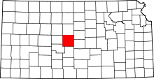 | |
| CDPs | ||
| Unincorporated communities | ||
| Townships | ||
| Footnotes | ‡This populated place also has portions in an adjacent county or counties | |