Dolenja Dobrava, Gorenja Vas–Poljane
| Dolenja Dobrava | |
|---|---|
|
Dolenja Dobrava | |
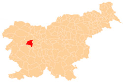
 Dolenja Dobrava Location in Slovenia | |
| Coordinates: 46°6′1.55″N 14°9′4.57″E / 46.1004306°N 14.1512694°ECoordinates: 46°6′1.55″N 14°9′4.57″E / 46.1004306°N 14.1512694°E | |
| Country |
|
| Traditional region | Upper Carniola |
| Statistical region | Upper Carniola |
| Municipality | Gorenja Vas–Poljane |
| Area | |
| • Total | 1.24 km2 (0.48 sq mi) |
| Elevation | 403.7 m (1,324.5 ft) |
| Population (2002) | |
| • Total | 204 |
| [1] | |
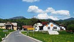
Dolenja Dobrava (pronounced [dɔˈleːnja dɔˈbɾaːʋa]; German: Doleinadobrawa[2]) is a small village on the right bank of the Poljane Sora River in the Municipality of Gorenja Vas–Poljane in the Upper Carniola region of Slovenia.[3]
References
- ↑ Statistical Office of the Republic of Slovenia
- ↑ Leksikon občin kraljestev in dežel zastopanih v državnem zboru, vol. 6: Kranjsko. 1906. Vienna: C. Kr. Dvorna in Državna Tiskarna, p. 64.
- ↑ Gorenja Vas–Poljane municipal site
External links
| Settlements | Administrative centre: Gorenja Vas
|  |
|---|---|---|
| Landmarks |
| |
| Notable people | ||
This article is issued from Wikipedia - version of the 12/29/2015. The text is available under the Creative Commons Attribution/Share Alike but additional terms may apply for the media files.