Diala Banlieue
| Diala Banlieue | |
|---|---|
| Village | |
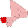
 Diala Banlieue Location in Mali | |
| Coordinates: ML 14°27′54″N 11°29′28″W / 14.46500°N 11.49111°WCoordinates: ML 14°27′54″N 11°29′28″W / 14.46500°N 11.49111°W | |
| Country |
|
| Region | Kayes Region |
| Cercle | Kayes Cercle |
| Commune | Liberte de Mbaya |
| Time zone | GMT (UTC+0) |
Diala Banlieue (also Dyalla) is a village and principal settlement (chef-lieu) of the commune of Liberté Dembaya in the Cercle of Kayes in the Kayes Region of south-western Mali.[1]
References
- ↑ Communes de la Région de Kayes (PDF) (in French), Ministère de l’administration territoriale et des collectivités locales, République du Mali.
This article is issued from Wikipedia - version of the 3/21/2012. The text is available under the Creative Commons Attribution/Share Alike but additional terms may apply for the media files.