D'Oyly Carte Island
D'Oyly Carte Island is a small private island in the River Thames, England, administratively and historically part of Weybridge near its other inhabited islands and part of Old Shepperton, on the reach above Sunbury Lock, 200m downstream of Shepperton Lock. Before 1890 the island was known as Folly Eyot.
Geography
The wooded island is 145m in length and, apart from its two points, 30-45m in width.[1] It is 16.8 miles (27.0 km) from Charing Cross, London.[2][1] Weybridge is the parish[3] and post town. Elmbridge and Surrey County Council are the district and county level local authorities.[4]
Etymology
The island was, until the eponymous owner bought it, called Folly Eyot. Richard D'Oyly Carte was the producer of the Gilbert and Sullivan comic operas from 1875 to 1896 (such as The Mikado), founder of the Savoy Theatre and Royal English Opera House (now the Palace Theatre) in London and a hotelier. He bought the island around 1890, and it acquired his middle name and surname.[5]
History
Carte intended to use as a special secluded annex, accessible by boat, to his new Savoy Hotel, but a panel of the local magistrates refused to grant him an alcoholic drinks selling licence for the property.[5] Among the famous guests who stayed at Carte's house on the island were the dramatist W. S. Gilbert and the composer Arthur Sullivan.[6] Carte's widow, Helen Carte, sold it to a private owner.
Features
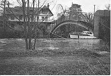
Carte built the main structure of the island, Eyot House, which has a large garden that he and his wife helped to design surrounded by trees, that he used as a residence.[7][8]
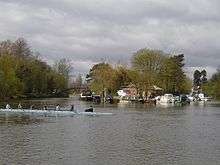
A small single span footbridge was built in 1964 to provide access to the house with brutalist railings and gates. This is a very high arch of a single steel box girder with treads.[9] The island has a marina that provides mooring to small boats.[2]
See also
References
- 1 2 Grid Reference Finder distance tools
- 1 2 "D'Oyly Carte Island marina", World Marine Guide, 2009, accessed 12 November 2012
- ↑ Weybridge St James Church of England
- ↑ Surrey Council Council interactive maps (various) (exact URLs and platform periodically changes) Retrieved 2013-10-26
- 1 2 Barrington, Rutland (1908). Rutland Barrington: A Record of 35 Years' Experience on the English Stage, By Himself, p. 73.
- ↑ Winn, Christopher. I Never Knew That about the River Thames (London: Ebury Press, 2010), p. 138
- ↑ Pauling, Keith. "Richard D’Oyly Carte", Thames Pathway: Journal of a Walk Down the River Thames, 2009 ISBN 1445222396
- ↑ "Shepperton Lock", About the Thames, accessed 11 April 2009
- ↑ A Guide to the Industrial Archaeology of the Borough of Elmbridge
External links
| Wikimedia Commons has media related to D'Oyly Carte Island. |
| Next island upstream | River Thames | Next island downstream |
| Lock Island Hamhaugh Island |
D'Oyly Carte Island | Desborough Island |
Coordinates: 51°22′58″N 00°27′15″W / 51.38278°N 0.45417°W