Cypress-Emerson Historic District
|
Cypress–Emerson Historic District | |
|
Waverly Street near Emerson Park | |
  | |
| Location | Roughly bounded by Waverly, Emerson, and Cypress Sts., Brookline, Massachusetts |
|---|---|
| Coordinates | 42°19′58.38″N 71°7′21.02″W / 42.3328833°N 71.1225056°WCoordinates: 42°19′58.38″N 71°7′21.02″W / 42.3328833°N 71.1225056°W |
| Architectural style | Late 19th And 20th Century Revivals, Late Victorian |
| MPS | Brookline MRA |
| NRHP Reference # | 85003257[1] |
| Added to NRHP | October 17, 1985 |
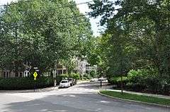
The Cypress—Emerson Historic District encompasses a residential part of Brookline, Massachusetts, which is reflective the growth of Brookline Village, the nearby commercial and retail area, through the 19th century. It consists of a section of Cypress Street roughly between Davis Avenue and Waverly Street, and a section of Waverly Street between Cypress and Davis, including Emerson Street and the Emerson Gardens park. Much of this area belonged to Moses Davis in the 1830s, who farmed the land. The area's major development took place between about 1870 and 1890. Notable residences in the district include 109-111 Davis Avenue, which was the home of Charles Rutan, one of the principals of Shepley, Rutan and Coolidge; Rutan designed this house as well as two others on nearby Elm Street.[2]
The district was listed on the National Register of Historic Places in 1985.[1]
See also
References
- 1 2 National Park Service (2008-04-15). "National Register Information System". National Register of Historic Places. National Park Service.
- ↑ "NRHP nomination for Cypress-Emerson Historic District". Commonwealth of Massachusetts. Retrieved 2014-05-13.
| Topics |  | ||||||||||||||||||||||||||||||
|---|---|---|---|---|---|---|---|---|---|---|---|---|---|---|---|---|---|---|---|---|---|---|---|---|---|---|---|---|---|---|---|
| Lists by county | |||||||||||||||||||||||||||||||
| Lists by city |
| ||||||||||||||||||||||||||||||
| Other lists | |||||||||||||||||||||||||||||||
| |||||||||||||||||||||||||||||||