Cypert, Arkansas
| Cypert, Arkansas | |
|---|---|
| Unincorporated community | |
 Cypert, Arkansas  Cypert, Arkansas | |
| Coordinates: 34°29′24″N 90°57′22″W / 34.49000°N 90.95611°WCoordinates: 34°29′24″N 90°57′22″W / 34.49000°N 90.95611°W | |
| Country | United States |
| State | Arkansas |
| County | Phillips |
| Elevation | 187 ft (57 m) |
| Time zone | Central (CST) (UTC-6) |
| • Summer (DST) | CDT (UTC-5) |
| Area code(s) | 870 |
| GNIS feature ID | 57621[1] |
Cypert is an unincorporated community in Phillips County, Arkansas, United States. The community is located on Arkansas Highway 318 5.2 miles (8.4 km) south-southwest of Marvell.
The Turner Historic District, which is listed on the National Register of Historic Places, is located in Cypert.[2]
References
| Wikimedia Commons has media related to Cypert, Arkansas. |
- ↑ "Cypert". Geographic Names Information System. United States Geological Survey.
- ↑ National Park Service (2010-07-09). "National Register Information System". National Register of Historic Places. National Park Service.
Municipalities and communities of Phillips County, Arkansas, United States | ||
|---|---|---|
| Cities | 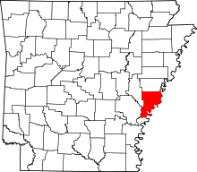 | |
| Town | ||
| Townships |
| |
| Unincorporated communities | ||
This article is issued from Wikipedia - version of the 7/29/2016. The text is available under the Creative Commons Attribution/Share Alike but additional terms may apply for the media files.