Phillips County, Arkansas
| Phillips County, Arkansas | |
|---|---|
 Phillips County courthouse in Helena-West Helena | |
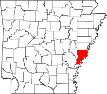 Location in the U.S. state of Arkansas | |
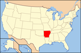 Arkansas's location in the U.S. | |
| Founded | May 1, 1820 |
| Seat | Helena-West Helena |
| Largest city | Helena-West Helena |
| Area | |
| • Total | 727 sq mi (1,883 km2) |
| • Land | 696 sq mi (1,803 km2) |
| • Water | 32 sq mi (83 km2), 4.4% |
| Population (est.) | |
| • (2015) | 19,513 |
| • Density | 31/sq mi (12/km²) |
| Congressional district | 1st |
| Time zone | Central: UTC-6/-5 |
| Website |
phillipscounty |
Phillips County is a county located in the U.S. state of Arkansas. As of the 2010 census, the population was 21,757.[1] The county seat is Helena-West Helena.[2] Phillips County is Arkansas's seventh county, formed on May 1, 1820, and named for Sylvanus Phillips, the area's first-known white settler and representative to the first Territorial Legislature of the Arkansas Territory. 237 people were lynched there in 1919 during the Elaine race riot, making Phillips County the site of the largest number of lynchings in U.S. history.[3]
The Helena-West Helena, AR Micropolitan Statistical Area includes all of Phillips County.
Geography
According to the U.S. Census Bureau, the county has a total area of 727 square miles (1,880 km2), of which 696 square miles (1,800 km2) is land and 32 square miles (83 km2) (4.4%) is water.[4]
Major highways
Adjacent counties
- Lee County (north)
- Tunica County, Mississippi (northeast)
- Coahoma County, Mississippi (east)
- Bolivar County, Mississippi (southeast)
- Desha County (south)
- Arkansas County (southwest)
- Monroe County (northwest)
National protected areas
Demographics
| Historical population | |||
|---|---|---|---|
| Census | Pop. | %± | |
| 1830 | 1,152 | — | |
| 1840 | 3,547 | 207.9% | |
| 1850 | 6,935 | 95.5% | |
| 1860 | 14,877 | 114.5% | |
| 1870 | 15,372 | 3.3% | |
| 1880 | 21,262 | 38.3% | |
| 1890 | 25,341 | 19.2% | |
| 1900 | 26,561 | 4.8% | |
| 1910 | 33,535 | 26.3% | |
| 1920 | 44,530 | 32.8% | |
| 1930 | 40,683 | −8.6% | |
| 1940 | 45,970 | 13.0% | |
| 1950 | 46,254 | 0.6% | |
| 1960 | 43,997 | −4.9% | |
| 1970 | 40,046 | −9.0% | |
| 1980 | 34,772 | −13.2% | |
| 1990 | 28,838 | −17.1% | |
| 2000 | 26,445 | −8.3% | |
| 2010 | 21,757 | −17.7% | |
| Est. 2015 | 19,513 | [5] | −10.3% |
| U.S. Decennial Census[6] 1790–1960[7] 1900–1990[8] 1990–2000[9] 2010–2015[1] | |||

As of the 2010 United States Census, there were 21,757 people residing in the county. 63.1% were Black or African American, 35.0% White, 0.3% Asian, 0.2% Native American, 0.4% of some other race and 0.9% of two or more races. 1.3% were Hispanic or Latino (of any race).
As of the 2000 United States Census,[11] there were 26,445 people, 9,711 households, and 6,768 families residing in the county. The population density was 38 people per square mile (15/km²). There were 10,859 housing units at an average density of 16 per square mile (6/km²). The racial makeup of the county was 59.04% Black or African American, 39.25% White, 0.43% from other races, 0.32% Asian, 0.17% Native American, 0.01% Pacific Islander, and 0.78% from two or more races. 1.44% of the population were Hispanic or Latino of any race.
There were 9,711 households out of which 34.20% had children under the age of 18 living with them, 40.30% were married couples living together, 25.10% had a female householder with no husband present, and 30.30% were non-families. 27.60% of all households were made up of individuals and 13.00% had someone living alone who was 65 years of age or older. The average household size was 2.69 and the average family size was 3.29.
In the county the population was spread out with 32.20% under the age of 18, 9.40% from 18 to 24, 23.20% from 25 to 44, 21.20% from 45 to 64, and 13.90% who were 65 years of age or older. The median age was 33 years. For every 100 females there were 84.70 males. For every 100 females age 18 and over, there were 77.70 males.
The median income for a household in the county was $22,231, and the median income for a family was $26,570. Males had a median income of $24,675 versus $17,520 for females. The per capita income for the county was $12,288. About 28.70% of families and 32.70% of the population were below the poverty line, including 45.50% of those under age 18 and 26.20% of those age 65 or over.
The Helena-West Helena statistical area had the largest drop in population, at −20.89%, of any statistical area in the country for the period 2000-2009.
Education
School districts serving Phillips County include the Helena-West Helena School District, the Marvell–Elaine School District, and the Barton–Lexa School District.
Previously the Lake View School District served a portion of the county. On July 1, 2004, the Lake View district merged into the Barton–Lexa district. Previously the Elaine School District served another portion of the county. On July 1, 2006, the Elaine district merged into the Marvell district.[12][13]
Marvell Academy, a private school founded in 1966[14] as a segregation academy.,[15] is in unincorporated Phillips County, near Marvell.[16]
Communities
Cities
- Elaine
- Helena-West Helena (county seat)
- Lake View
- Marvell
Town
Unincorporated places
Townships
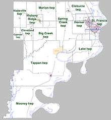
Townships in Arkansas are the divisions of a county. Each township includes unincorporated areas; some may have incorporated cities or towns within part of their boundaries. Arkansas townships have limited purposes in modern times. However, the United States Census does list Arkansas population based on townships (sometimes referred to as "county subdivisions" or "minor civil divisions"). Townships are also of value for historical purposes in terms of genealogical research. Each town or city is within one or more townships in an Arkansas county based on census maps and publications. The townships of Phillips County are listed below; listed in parentheses are the cities, towns, and/or census-designated places that are fully or partially inside the township. [17][18]
| Township | FIPS code | ANSI code (GNIS ID) |
Population center(s) |
Pop. (2010) |
Pop. density (/mi²) |
Pop. density (/km²) |
Total area (mi²) |
Total area (km²) |
Land area (mi²) |
Land area (km²) |
Water area (mi²) |
Water area (km²) |
Geographic coordinates |
|---|---|---|---|---|---|---|---|---|---|---|---|---|---|
| Big Creek | 05-90273 | 00068945 | 425 | 11.05 | 4.26 | 38.474 | 99.65 | 38.474 | 99.65 | 0 | 0.000 | 34°29′04″N 90°53′36″W / 34.484468°N 90.893231°W | |
| Cleburne | 05-90849 | 00068946 | 660 | 29.12 | 11.24 | 22.692 | 58.77 | 22.665 | 58.70 | 0.027 | 0.06993 | 34°36′32″N 90°41′27″W / 34.608847°N 90.690904°W | |
| Cleveland | 05-90870 | 00068947 | 198 | 8.01 | 3.09 | 24.731 | 64.05 | 24.722 | 64.03 | 0.009 | 0.02331 | 34°28′46″N 90°58′19″W / 34.479487°N 90.971919°W | |
| Cypress | 05-91005 | 00068948 | 152 | 9.54 | 3.68 | 15.938 | 41.28 | 15.938 | 41.28 | 0 | 0.000 | 34°28′35″N 91°01′08″W / 34.476511°N 91.018900°W | |
| Hickory Ridge | 05-91704 | 00068949 | Marvell | 1,550 | 49.89 | 19.26 | 31.10 | 80.55 | 31.066 | 80.46 | 0.034 | 0.08806 | 34°35′11″N 90°56′11″W / 34.586411°N 90.936268°W |
| Hicksville | 05-91707 | 00068950 | 231 | 6.99 | 2.70 | 33.046 | 85.59 | 33.046 | 85.59 | 0 | 0.000 | 34°35′11″N 91°01′00″W / 34.586511°N 91.016744°W | |
| Hornor | 05-91767 | 00068951 | part of Helena-West Helena | 9,697 | 265.48 | 102.51 | 36.526 | 94.60 | 36.526 | 94.60 | 0 | 0.000 | 34°32′24″N 90°40′45″W / 34.539980°N 90.679052°W |
| Lake | 05-92094 | 00068953 | 41 | 0.91 | 0.35 | 50.741 | 131.4 | 44.870 | 116.2 | 5.871 | 15.21 | 34°24′38″N 90°40′36″W / 34.410535°N 90.676788°W | |
| Marion | 05-92391 | 00068955 | 589 | 14.42 | 5.57 | 40.865 | 105.8 | 40.846 | 105.8 | 0.019 | 0.04921 | 34°35′51″N 90°52′13″W / 34.597488°N 90.870256°W | |
| Mooney | 05-92547 | 00078865 | 179 | 1.70 | 0.66 | 115.059 | 298.0 | 105.231 | 272.5 | 9.828 | 25.45 | 34°11′30″N 90°58′10″W / 34.191547°N 90.969308°W | |
| St. Francis | 05-93276 | 00068956 | most of Helena-West Helena | 4,746 | 103.10 | 39.82 | 53.971 | 139.8 | 46.034 | 119.2 | 7.937 | 20.56 | 34°32′21″N 90°36′13″W / 34.539209°N 90.603521°W |
| Spring Creek | 05-93462 | 00068958 | Lexa, small part of Lake View | 1,789 | 22.46 | 8.67 | 79.694 | 206.4 | 79.648 | 206.3 | 0.046 | 0.1191 | 34°31′40″N 90°45′56″W / 34.527768°N 90.765687°W |
| Tappan | 05-93573 | 00068959 | Elaine, most of Lake View | 1,500 | 8.49 | 3.28 | 184.506 | 477.9 | 176.595 | 457.4 | 7.911 | 20.49 | 34°20′37″N 90°52′49″W / 34.343723°N 90.880168°W |
| Source: "Census 2010 U.S. Gazetteer Files: County Subdivisions in Arkansas". U.S. Census Bureau, Geography Division.
Source: "Census 2010 U.S. Gazetteer Files". U.S. Census Bureau, Geography Division. | |||||||||||||
Notable people
- Bruce Bennett,[19] Arkansas Attorney General
- Barry Williamson, attorney and member of the Texas Railroad Commission
- Blanche Lincoln, U.S. Senator
- Mark Lavon "Levon" Helm, drummer and singer for The Band
See also
- National Register of Historic Places listings in Phillips County, Arkansas
- Phillips County - Largest number of lynchings of any US County
References
- 1 2 "State & County QuickFacts". United States Census Bureau. Retrieved May 19, 2014.
- ↑ "Find a County". National Association of Counties. Retrieved 2011-06-07.
- ↑ Robertson, Campbell (February 10, 2015). "History of Lynchings in the South Documents Nearly 4,000 Names". The New York Times.
- ↑ "2010 Census Gazetteer Files". United States Census Bureau. August 22, 2012. Retrieved August 27, 2015.
- ↑ "County Totals Dataset: Population, Population Change and Estimated Components of Population Change: April 1, 2010 to July 1, 2015". Retrieved July 2, 2016.
- ↑ "U.S. Decennial Census". United States Census Bureau. Retrieved August 27, 2015.
- ↑ "Historical Census Browser". University of Virginia Library. Retrieved August 27, 2015.
- ↑ Forstall, Richard L., ed. (March 27, 1995). "Population of Counties by Decennial Census: 1900 to 1990". United States Census Bureau. Retrieved August 27, 2015.
- ↑ "Census 2000 PHC-T-4. Ranking Tables for Counties: 1990 and 2000" (PDF). United States Census Bureau. April 2, 2001. Retrieved August 27, 2015.
- ↑ Based on 2000 census data
- ↑ "American FactFinder". United States Census Bureau. Retrieved 2011-05-14.
- ↑ "Consolidation/Annexations of LEA's (1983-2010)." Arkansas Department of Education. Retrieved on March 2, 2011.
- ↑ "Education Board approves mergers, removes Greenland from fiscal distress". 13 March 2006. Retrieved 12 September 2014.
- ↑ "About." Marvell Academy. Retrieved on March 2, 2011.
- ↑ "Private Schools: The Last Refuge." TIME. Friday November 14, 1969. Retrieved on March 2, 2011.
- ↑ "Marvell Academy Principals." Manta. Retrieved on March 2, 2011. "645 Highway 243 Marvell, AR 72366."
- ↑ 2011 Boundary and Annexation Survey (BAS): Phillips County, AR (PDF) (Map). U. S. Census Bureau. Retrieved 2011-08-21.
- ↑ "Arkansas: 2010 Census Block Maps - County Subdivision". United States Census Bureau. Retrieved June 28, 2014.
- ↑ "Bruce Bennett (1917-1979)". encyclopediaofarkansas.net. Retrieved May 10, 2010.
 |
Monroe County | Lee County | Tunica County, Mississippi | |
| |
Coahoma County, Mississippi | |||
| ||||
| | ||||
| Arkansas County | Desha County | Bolivar County, Mississippi |
Municipalities and communities of Phillips County, Arkansas, United States | ||
|---|---|---|
| Cities | | |
| Town | ||
| Townships |
| |
| Unincorporated communities | ||

Coordinates: 34°23′25″N 90°52′11″W / 34.39028°N 90.86972°W