Cusy
| Cusy | ||
|---|---|---|
|
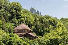
A general view of Cusy | ||
| ||
 Cusy | ||
|
Location within Auvergne-Rhône-Alpes region  Cusy | ||
| Coordinates: 45°45′57″N 6°01′53″E / 45.7658°N 6.0314°ECoordinates: 45°45′57″N 6°01′53″E / 45.7658°N 6.0314°E | ||
| Country | France | |
| Region | Auvergne-Rhône-Alpes | |
| Department | Haute-Savoie | |
| Arrondissement | Annecy | |
| Canton | Alby-sur-Chéran | |
| Intercommunality | Communauté de communes du Pays d'Alby-sur-Chéran | |
| Government | ||
| • Mayor (2008–2014) | Jean-Claude Guerraz | |
| Area1 | 17.43 km2 (6.73 sq mi) | |
| Population (1999)2 | 1,270 | |
| • Density | 73/km2 (190/sq mi) | |
| Time zone | CET (UTC+1) | |
| • Summer (DST) | CEST (UTC+2) | |
| INSEE/Postal code | 74097 / 74540 | |
| Elevation | 420–1,365 m (1,378–4,478 ft) | |
|
1 French Land Register data, which excludes lakes, ponds, glaciers > 1 km² (0.386 sq mi or 247 acres) and river estuaries. 2 Population without double counting: residents of multiple communes (e.g., students and military personnel) only counted once. | ||
%2C_vue_g%C3%A9n%C3%A9rale.jpg)

Cusy is a commune in the Haute-Savoie department in the Auvergne-Rhône-Alpes region in south-eastern France.
Geography
The Chéran forms the commune's north-eastern border.
See also
References
| Wikimedia Commons has media related to Cusy. |
This article is issued from Wikipedia - version of the 10/28/2016. The text is available under the Creative Commons Attribution/Share Alike but additional terms may apply for the media files.