County of Polwarth
| Polwarth Victoria | |||||||||||||
|---|---|---|---|---|---|---|---|---|---|---|---|---|---|
 Location in Victoria | |||||||||||||
| |||||||||||||
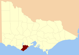
The County of Polwarth is one of the 37 counties of Victoria which are part of the cadastral divisions of Australia, used for land titles. The County is in the Western District of Victoria and includes the Cape Otway area, bounded by the Gellibrand River in the west and the Anglesea River and Barwon River in the east, in the north by a line from Winchelsea, through Colac to Larpent, and by Bass Strait to the south. The largest town is Colac. The County was proclaimed in 1849.
Parishes
Parishes within the county:
- Aire
- Angahook
- Bambra
- Barongarook
- Barramunga
- Barwon Downs
- Barwongemoong
- Birregurra (part in the County of Grenville)
- Boonah
- Colac
- Elliminyt
- Gerangamete
- Irrewarra
- Irrewillipe
- Kaanglang
- Krambruk
- La Trobe (part in the County of Heytesbury)
- Lorne
- Moomowroong
- Moorbanool
- Murroon
- Nalangil
- Natte Murrang
- Newlingrook
- Olangolah
- Otway
- Pirron Yaloak
- Wangerrip
- Warrion (part in the County of Grenville)
- Weeaproinah
- Wensleydale
- Whoorel
- Wongarra
- Wyelangta
- Yan Yan Gourt
- Yaugher
- Yeo
References
- ↑ Rootsweb Genealogy, Victorian Counties, retrieved 2008-09-20
External links
- Research aids, Victoria 1910
- Map of the counties of Talbot, Dalhousie, Anglesey, Bourke, Grenville, Grant, Mornington, Polwarth / John Sands
Coordinates: 38°30′S 143°30′E / 38.500°S 143.500°E
This article is issued from Wikipedia - version of the 8/11/2013. The text is available under the Creative Commons Attribution/Share Alike but additional terms may apply for the media files.