Colney
| Colney | |
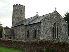 St Andrew's church |
|
 Colney |
|
| Area | 3.83 km2 (1.48 sq mi) |
|---|---|
| Population | 153 (2011) |
| – density | 40/km2 (100/sq mi) |
| OS grid reference | TG181079 |
| Civil parish | Colney |
| District | South Norfolk |
| Shire county | Norfolk |
| Region | East |
| Country | England |
| Sovereign state | United Kingdom |
| Post town | NORWICH |
| Postcode district | NR4 |
| Police | Norfolk |
| Fire | Norfolk |
| Ambulance | East of England |
| EU Parliament | East of England |
Coordinates: 52°37′31″N 1°13′18″E / 52.625353°N 1.221714°E
Colney is a village in the western outskirts of Norwich in Norfolk, England. It is in the administrative district of South Norfolk. It covers an area of 3.83 km2 (1.48 sq mi) and had a population of 124 in 35 households at the 2001 census,[1] increasing to 153 at the 2011 census.[2]
Its church, St Andrew, is one of 124 existing round-tower churches in Norfolk.
Colney is home to the Norfolk and Norwich University Hospital, John Innes Centre, Institute of Food Research and the location of Norwich City F.C.'s training ground.[3]
The River Yare flows through it.
Notes
- ↑ "Colney parish information". South Norfolk Council. 4 January 2006. Retrieved 20 June 2009.
- ↑ "Parish population 2011". Retrieved 6 September 2015.
- ↑ Norwich City FC training ground Retrieved 26 June 2014
External links
![]() Media related to Colney at Wikimedia Commons
Media related to Colney at Wikimedia Commons
This article is issued from Wikipedia - version of the 8/2/2016. The text is available under the Creative Commons Attribution/Share Alike but additional terms may apply for the media files.