Bramerton
| Bramerton | |
 Bramerton |
|
| Area | 2.96 km2 (1.14 sq mi) |
|---|---|
| Population | 301 (2011) |
| – density | 102/km2 (260/sq mi) |
| OS grid reference | TG292038 |
| Civil parish | Bramerton |
| District | South Norfolk |
| Shire county | Norfolk |
| Region | East |
| Country | England |
| Sovereign state | United Kingdom |
| Post town | NORWICH |
| Postcode district | NR14 |
| Police | Norfolk |
| Fire | Norfolk |
| Ambulance | East of England |
| EU Parliament | East of England |
Coordinates: 52°35′00″N 1°23′00″E / 52.5833°N 1.3833°E
Bramerton is a village in South Norfolk 4¾ miles (7½ km) south-east of Norwich, just north of the main A146 Norwich-Lowestoft road and on the south bank of the River Yare. In the 2001 census it contained 158 households and a population of 350,[1] the population falling to 301 at the 2011 census.[2]
The village
Bramerton (from Old English,'farmstead by the bramble thicket')[3] is centred along The Street, on which stands St. Peter's Church, a grade II listed building. Evidence of early settlement found in the village includes Neolithic axeheads, fragments of Iron Age pottery and an Iron Age terret or rein guide, Roman potsherds and a Roman coin. Part of an Early Saxon brooch and pieces of Middle Saxon pottery have also been found in Bramerton, which was listed in the Domesday Book.[3]
Opposite the church lies Church Farm, once the site of Herbert Parker Ltd agricultural and seed merchants, but now Church Farm Business Centre. Bramerton Hall, on the corner of The Street and Surlingham Lane, also grade II listed, is a brick-built house dating from about 1830.[4] Several houses in the village are considerably older. The Grange, Warren Cottage, and Orchard House all date from the 17th century.[3]
Bramerton no longer has a post office (closed 1968), shop (closed 1977) or school (closed 1978) but still has a pub, originally the Woods End, now renamed the Water's Edge, which lies on the south bank of the River Yare to the north of the village centre, in the hamlet of Woods End. At the north end of the village is a Dawn Christadelphian Hall, first opened in 1952 and extended in the 1960s and then again in the 1980s. A secondary hall for youth activities was added in the 2000s.[5] Bramerton Health Care Clinic offers homoeopathy, herbal supplements and dietary advice.
Bramerton is part of South Norfolk District, but parts of the village lying adjacent to and in the vicinity of the river fall into the executive area of the Broads Authority.
St. Peter's Church

The entrance to the churchyard is via a lych-gate built in the late 1920s by local carpenter John Shingles using oak from local trees.[5] Parts of the church date from the 13th century. It was extensively rebuilt in 1462 and following restoration in the 19th century the interior is now almost entirely Victorian. A church is mentioned in the Domesday Book and the present building contains Roman bricks and stone from Caen in Normandy, suggesting it replaced an earlier church.[3]
Woods End

There has been an inn on the site since before 1700. In 1828 the area and the nearby river were painted by Joseph Stannard, prominent in the Norwich School; entitled Boats on the Yare near Bramerton, Norfolk, his painting is now in the Fitzwilliam Museum in Cambridge. In Victorian times the inn possessed tea rooms and gardens popular with river-borne day-trippers from Norwich. The Woods End is still a popular spot for the mooring of pleasure craft and is also one of the few places on the Norfolk Broads where water skiing is allowed. Outside the pub (now renamed the Water's Edge) is a statue of Billy Bluelight (William Cullum), who in the 1920s–30s used to challenge boat trippers to a race along the river bank. He is famed for his claim... "My name is Billy Bluelight, my age is 45, I hope to get to Carrow Bridge before the boat arrive." He is said to have remained '45' for many years.[6] Just to the east lies Bramerton Common, a public staithe and green. The rocks coming to the surface in the woods adjacent to the common have given their name to an inter-glacial stage in Britain's pre-history (see Geology below).

Geology
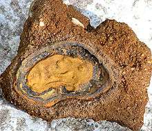
The rock strata reaching the surface at Bramerton Pits, adjacent to the Common at Woods End, have resulted in the name of the village being given to an early Pleistocene glacial stage in the geological pre-history of the British Isles. The Bramertonian Stage is distinguished by the presence of shelly, sandy deposits indicative of a temperate climate.[7] Bramerton Pits has been noted as a Site of Special Scientific Interest on account of the geology and has been excavated on several occasions.
Sports and recreation
Bramerton and District Bowls club was founded in 1965, moving to its current location near the village hall in 1972. The village hall itself was erected by voluntary labour in 1988 after having been rescued from its previous existence as a Surlingham bungalow. The village hall is now the venue for a range of activities

including a play group called Sunbeams, Brownies and yoga. Adjacent to the Bowls club is a children's playground with swings, climbing frame and slide. At Grange Farm Barns in the centre of the village is a Caravan Club certified location.[8]
Transport links
Bramerton is served by bus route 85 operated by Anglian Coaches providing six services a day into Norwich via Kirby Bedon and to the neighbouring villages of Surlingham and Rockland St. Mary.[9]
National Cycle Route 1 passes through Bramerton on its route from Norwich via Trowse and Whitlingham and out to Loddon via Surlingham.
The Wherryman's Way a Long distance footpath passes close by at Woods End.
Nearby villages
- Kirby Bedon – 1.5 miles (2.4 km) west
- Surlingham – 1.5 miles (2.4 km) northeast
- Rockland St. Mary – 1.25 miles (2.01 km) east
- Framingham Pigot – 1.25 miles (2.01 km) southwest
External links
![]() Media related to Bramerton at Wikimedia Commons
Media related to Bramerton at Wikimedia Commons
- Bramerton Village website
- Water's Edge, Bramerton Woods End
- Ordnance Survey Pathfinder (1:25000) map of Bramerton
- A stroll around Bramerton and Surlingham
- EDP Walk
- Bramerton on GENUKI
- Bramerton Pits
References
- ↑ Bramerton parish information [South Norfolk Council]
- ↑ "Parish population 2011". Retrieved 9 September 2015.
- 1 2 3 4 http://www.heritage.norfolk.gov.uk/record-details?uid=%27TNF152
- ↑ http://www.britishlistedbuildings.co.uk/en-227144-bramerton-hall-bramerton-norfolk
- 1 2 Bramerton booklet produced by the Bramerton Society in 1991
- ↑ Discover the Heart of the Broads
- ↑ The Crag at Bramerton, Near Norwich, Norfolk
- ↑ CL Site GPS file small.xls
- ↑ Anglian Coaches Timetable