Colby, Wisconsin
| Colby, Wisconsin | |
|---|---|
| City | |
|
Downtown Colby | |
|
Motto: "A Growing Community Proud of Its Heritage" "Home of Colby Cheese" | |
 Location of Colby, Wisconsin | |
| Coordinates: 44°54′37″N 90°19′1″W / 44.91028°N 90.31694°WCoordinates: 44°54′37″N 90°19′1″W / 44.91028°N 90.31694°W | |
| Country | United States |
| State | Wisconsin |
| Counties | Clark, Marathon |
| Area[1] | |
| • Total | 1.57 sq mi (4.07 km2) |
| • Land | 1.56 sq mi (4.04 km2) |
| • Water | 0.01 sq mi (0.03 km2) |
| Elevation[2] | 1,352 ft (412 m) |
| Population (2010)[3] | |
| • Total | 1,852 |
| • Estimate (2012[4]) | 1,836 |
| • Density | 1,187.2/sq mi (458.4/km2) |
| Time zone | Central (CST) (UTC-6) |
| • Summer (DST) | CDT (UTC-5) |
| Area code(s) | 715 Exchange: 223 |
| FIPS code | 55-16150[5] |
| GNIS feature ID | 1563232[2] |
| Website |
www |

Colby is a city in Clark (mostly) and Marathon counties in the U.S. state of Wisconsin. It is part of the Wausau, Wisconsin Metropolitan Statistical Area. The population was 1,852 at the 2010 census.[6] Of this, 1,354 were in Clark County, and 498 were in Marathon County. The city is bordered by the Town of Colby, the Town of Hull, and the City of Abbotsford.
History
When the Wisconsin Central Railroad was building its line through the wilderness heading toward Lake Superior, it finished its 1872 construction season with rails completed to the site of today's Colby. The place was initially called "Section 53," but the railroad renamed the station in honor of Charles L. Colby, partner in the construction company that was building the railroad, and the son of the railroad's financier Gardner L. Colby.[7]
Colby is the birthplace of Colby cheese. A historical marker in downtown Colby commemorates the development of Colby cheese by Joseph Steinwand in 1874.[8] Colby cheese is no longer made in the city of Colby, although a factory east of town cuts and packages it. The former Colby cheese factory west of the city is a dilapitated building.
Geography
Colby is located at 44°54′36″N 90°19′1″W / 44.91000°N 90.31694°W (44.910186, -90.317058).[9]
According to the United States Census Bureau, the city has a total area of 1.57 square miles (4.07 km2), of which, 1.56 square miles (4.04 km2) is land and 0.01 square miles (0.03 km2) is water.[1]
Demographics
| Historical population | |||
|---|---|---|---|
| Census | Pop. | %± | |
| 1880 | 259 | — | |
| 1900 | 667 | — | |
| 1910 | 869 | 30.3% | |
| 1920 | 798 | −8.2% | |
| 1930 | 849 | 6.4% | |
| 1940 | 903 | 6.4% | |
| 1950 | 989 | 9.5% | |
| 1960 | 1,085 | 9.7% | |
| 1970 | 1,178 | 8.6% | |
| 1980 | 1,496 | 27.0% | |
| 1990 | 1,532 | 2.4% | |
| 2000 | 1,616 | 5.5% | |
| 2010 | 1,852 | 14.6% | |
| Est. 2015 | 1,828 | [10] | −1.3% |
2010 census
As of the census[3] of 2010, there were 1,852 people, 714 households, and 474 families residing in the city. The population density was 1,187.2 inhabitants per square mile (458.4/km2). There were 757 housing units at an average density of 485.3 per square mile (187.4/km2). The racial makeup of the city was 89.4% White, 0.6% African American, 0.4% Native American, 0.5% Asian, 0.1% Pacific Islander, 8.6% from other races, and 0.5% from two or more races. Hispanic or Latino of any race were 11.9% of the population.

There were 714 households of which 32.6% had children under the age of 18 living with them, 52.2% were married couples living together, 9.2% had a female householder with no husband present, 4.9% had a male householder with no wife present, and 33.6% were non-families. 27.9% of all households were made up of individuals and 15.6% had someone living alone who was 65 years of age or older. The average household size was 2.46 and the average family size was 2.99.
The median age in the city was 36.9 years. 25.1% of residents were under the age of 18; 8.6% were between the ages of 18 and 24; 24.6% were from 25 to 44; 21.7% were from 45 to 64; and 20% were 65 years of age or older. The gender makeup of the city was 48.1% male and 51.9% female.
2000 census
As of the census[5] of 2000, there were 1,616 people, 623 households, and 423 families residing in the city. The population density was 1,090.1 people per square mile (421.6/km²). There were 645 housing units at an average density of 435.1 per square mile (168.3/km²). The racial makeup of the city was 96.53% White, 0.19% Black or African American, 0.37% Native American, 0.43% Asian, 1.73% from other races, and 0.74% from two or more races. Hispanic or Latino of any race were 3.84% of the population.
There were 623 households out of which 33.5% had children under the age of 18 living with them, 55.9% were married couples living together, 8.0% had a female householder with no husband present, and 32.1% were non-families. 28.4% of all households were made up of individuals and 19.1% had someone living alone who was 65 years of age or older. The average household size was 2.43 and the average family size was 2.96.
In the city the population was spread out with 25.1% under the age of 18, 6.7% from 18 to 24, 25.4% from 25 to 44, 18.5% from 45 to 64, and 24.2% who were 65 years of age or older. The median age was 40 years. For every 100 females there were 87.3 males. For every 100 females age 18 and over, there were 82.2 males.
The median income for a household in the city was $34,318, and the median income for a family was $41,685. Males had a median income of $30,530 versus $21,806 for females. The per capita income for the city was $16,137. About 3.7% of families and 7.0% of the population were below the poverty line, including 6.1% of those under age 18 and 16.2% of those age 65 or over. Colby, is split between one of the richest counties, (Marathon) and one of the poorest (Clark) in the state of Wisconsin.

Education
Colby is part of the Colby School District. Schools in the district include a preschool, elementary school, middle school and high school. Students attend Colby High School.[12] Also located within the city is St. Mary's Catholic School, which serves students from 1st through 8th grade. The private and public schools have collaborative sports and band programs.
Events
Since 1961 Colby has put on the Colby Cheese Days festival on the third weekend in July. Events include a softball tournament, tractor pull, carnival rides, bingo, cheese-curd throwing contest, a fun-run, and finally a parade. Free cheese is distributed by vendors and food stands.
Notable people
- Kirk Baumgartner, NAIA college football All-American at the University of Wisconsin–Stevens Point
- George Washington Blanchard, U.S. congressman
- James E. Lyons, Wisconsin State Assemblyman and Mayor of Colby
- Joseph Weix, Wisconsin State Assemblyman
Images
 Welcome sign
 Sign
Sign
References
- 1 2 "US Gazetteer files 2010". United States Census Bureau. Archived from the original on 2012-06-26. Retrieved 2012-11-18.
- 1 2 "US Board on Geographic Names". United States Geological Survey. 2007-10-25. Retrieved 2008-01-31.
- 1 2 "American FactFinder". United States Census Bureau. Retrieved 2012-11-18.
- ↑ "Population Estimates". United States Census Bureau. Archived from the original on 2013-06-17. Retrieved 2013-06-24.
- 1 2 "American FactFinder". United States Census Bureau. Archived from the original on 2013-09-11. Retrieved 2008-01-31.
- ↑ "Profile of General Population and Housing Characteristics: 2010 Demographic Profile Data (DP-1): Colby city, Wisconsin". U.S. Census Bureau, American Factfinder. Archived from the original on September 11, 2013. Retrieved September 6, 2012.
- ↑ Martin, Roy L. (January 1941). History of the Wisconsin Central. Boston, Massachusetts: The Railroad and Locomotive Society, Baker Library, Harvard Business School. p. 19.
- ↑ http://www.ci.colby.wi.us/history_page/
- ↑ "US Gazetteer files: 2010, 2000, and 1990". United States Census Bureau. 2011-02-12. Retrieved 2011-04-23.
- ↑ "Annual Estimates of the Resident Population for Incorporated Places: April 1, 2010 to July 1, 2015". Retrieved July 2, 2016.
- ↑ "Census of Population and Housing". Census.gov. Archived from the original on May 11, 2015. Retrieved June 4, 2015.
- ↑ "Colby School District". Colby School District. Retrieved July 21, 2012.
External links
| Wikimedia Commons has media related to Colby, Wisconsin. |
- City of Colby official website
- Colby School District
- Sanborn fire insurance maps: 1884 1894 1900 1914
Municipalities and communities of Clark County, Wisconsin, United States | ||
|---|---|---|
| Cities |  | |
| Villages | ||
| Towns | ||
| CDPs | ||
| Unincorporated communities | ||
| Ghost towns | ||
| Footnotes | ‡This populated place also has portions in an adjacent county or counties | |
Municipalities and communities of Marathon County, Wisconsin, United States | ||
|---|---|---|
| Cities | 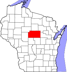 | |
| Villages | ||
| Towns |
| |
| CDPs | ||
| Unincorporated communities |
| |
| Ghost towns/ neighborhoods | ||
| Footnotes | ‡This populated place also has portions in an adjacent county or counties | |