Cherry Street (Toronto)
Cherry Street is a north-south roadway in Toronto, Ontario, Canada. Cherry Street is carried over the waterways of the Port Lands by Toronto's only two lift bridges. A smaller one where it crosses the Keating Channel and a larger one where it crosses the channel to the turning basin. Its northern terminus is at Eastern Avenue. A co-linear street, named Sumach St., continues north. It crosses Front St., Mill St., Lake Shore Boulevard, Commissioners Street and Unwin Ave. After crossing Unwin, it continues another 200 metres south to Cherry Beach, where it turns east and runs parallel to the beach for another 200 metres.
According to The Canadian Entomologist Cherry Street, between Unwin Ave. and the Keating Channel was the first recorded site of termite infestation in Ontario.[1][2]
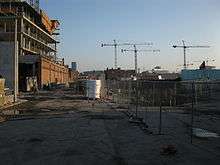
In 2012 the Toronto Transit Commission started to construct the first segment of a new streetcar line beside Cherry Street, from King Street 700 metres south to Lake Shore Boulevard.[3][4] This initial segment is projected to cost $90 million CAD. Original plans called for the line to extend further south into redeveloped portlands. That extension pushed the budget for the line to $300 million CAD.
The intersection of Cherry and Front streets is being described as the future gateway to the "Canary District", 200 acres of former light industrial land being redeveloped into a residential area.[5]
Thousands of athletes will be housed in a temporary athlete's village just east of the intersection of Cherry and Front streets during the 2015 Pan American Games and Parapan American Games.[6] According to transit advocate Steve Munro a large lot on the Northwest corner of Cherry and Front will serve as a temporary bus marshaling yards for the large fleet of rented buses which will carry athletes to their venues.
In early plans athletes would have ridden a streetcar to Union Station to make connections to the games' scattered venues. However, the streetcar's opening was delayed until after the games were over.[7][8] The apartments that will house the athletes were made available only partially complete. Since the athletes dined at central cafeterias completing the apartment's kitchens was postponed. That way the rooms intended to serve as kitchens could be used as an additional bedroom. Other fittings, like hardwood floors that could be damaged by the spikes on sports shoes, were installed after the games were over. The TTC announced the streetcar's route in 2016. The route, to be named the 514 Cherry, would run from the Cherry Loop, along King, to the Dufferin Gate Loop, near Liberty Village.
References
- ↑ F. A. Urquhart (1953). "The Introduction of the Termite into Ontario". The Canadian Entomologist. Retrieved 2012-03-13.
the termite was introduced into Ontario from the United States between the years 1935 and 1938, and that the point of introduction was in the vicinity of Cherry Street between Keating and Unwin Avenue on the ...
- ↑ C. S. Kirby (1965). "The Distribution of Termites in Ontario after 25 Years". The Canadian Entomologist. Retrieved 2012-03-13.
- ↑ Adrian Morrow (2012-05-25). "A tiny perfect streetcar line is being laid along Cherry Street". Globe and Mail. Retrieved 2012-07-19.
There’s a new streetcar line under construction in Toronto, the first in more than a decade and a surprising development during the tenure of a mayor who is outspokenly opposed to light rail.
- ↑ Tess Kalinowski (2007-12-11). "Transit-first street plan hailed". Toronto Star. Retrieved 2012-07-19.
Unlike Toronto's other streetcar routes, which traditionally run in mixed traffic and board passengers from platforms in the middle of the road, the Cherry St. plan calls for putting all the transit on the east side of the street, running in two directions, with a tree-lined platform separating it from other traffic.
"Two figures incorrect in Cherry St. transit plan". Toronto Star. 2007-12-12. Retrieved 2012-07-19.The transitway envisioned for this section is 700 metres.
- ↑ "Canary district" (PDF). Canarydistrict.com. Archived (PDF) from the original on 2014-10-03.
The iconic intersection of Front Street and Cherry Street is not just the doorway to the Canary District, but also a window to a storied past. Here, timeless history lives in harmony with 21st century infrastructure, a master-planned vision of past, present and future.
- ↑ Justin Skinner (2014-10-01). "Pan Am Athletes' Village nearly complete in Canary District". Inside Toronto. Archived from the original on 2014-10-03.
The village will be located in the Canary District in the West Don Lands, near Front and Cherry streets. The buildings that comprise the Athletes’ Village will be converted to 810 units of market housing and 253 units of affordable housing once the Games are done, and the site will also be home to housing for students at George Brown College and the Cooper Koo Family YMCA.
- ↑ Tess Kalinowski (2014-10-01). "TTC won't run streetcars on Cherry until at least 2016". Toronto Star. Archived from the original on 2014-10-03.
The Cherry streetcar service was never intended to begin until after the Pan Am Games next summer, during which the street will be a closed security zone, said Councillor Pam McConnell (Ward 28, Toronto Centre-Rosedale).
- ↑ "Relief could be coming to King streetcar in June". CBC News. 2016-03-16. Retrieved 2016-03-16.
A report made public Wednesday recommends that the new route begin service on June 19. It would operate between the Distillery Loop in the east and the Dufferin Gates loop in the west via Cherry, King and Dufferin streets.
Major roads, highways and streets in Toronto | |||||||||||
|---|---|---|---|---|---|---|---|---|---|---|---|
| North-south |
| ||||||||||
| East-west |
| ||||||||||
| |||||||||||
| |||||||||||
Coordinates: 43°38′41″N 79°21′06″W / 43.6446°N 79.3518°W