Highways in Ontario
The Ontario provincial highway network consists of all public highways maintained by the Canadian province of Ontario. The Ministry of Transportation of Ontario (MTO) maintains over 16,600 kilometres (10,300 mi) of roadways organized into various classifications which crisscross the province and provide access to major population centres.
Like most provinces, Ontario established a highway network in early 1920 as a result of the Canada Highways Act. Initially, the responsibility for these roads fell under the Department of Public Highways. In 1930, the department was renamed as the Department of Highways (DHO). Roadways in sparsely populated northern Ontario fell under the Department of Northern Development (DND) until it was merged into the DHO in 1937. That same year, the first divided highway and interchange in Canada – The Middle Road – was opened, inspired by German autobahns. Following World War II, construction of highways was accelerated; the first fully controlled-access highway was opened between Toronto and Barrie in 1952, the 825 km (513 mi) Highway 401 was navigable in 1964, and a network of secondary and collector highways was constructed through the rugged Canadian Shield throughout the 1950s. In 1960, The Gap opened along the north shore of Lake Superior and completed the Trans-Canada Highway in the province. The decade that followed saw the opening or planning of almost every freeway in Southern Ontario completed to date. In recent years, work has been focused on twinning existing routes into divided highways rather than establishing new corridors.
Highway classes
Ontario has several distinct classes of highways: King's Highways, (which includes Controlled-access highways) and secondary highways, with individual highways referred to as "that part of the King's Highway known as No. xx," or simply "the King's Highway known as No. xx." [1] For the purposes of legal jurisdiction, however, the Highway Traffic Act deems that tertiary roads are also considered to be "King's Highways".[2]
The term "the King's Highway" was first adopted in place of "provincial highway" in 1930, and signs similar to the current design but with the words THE KING'S HIGHWAY above the route number replaced the previous smaller triangular signs.[3][4] However, this name has been deprecated since the 1990s, and the old signs were replaced circa 1993. Currently these highways are again identified as "provincial highways"[5] or "provincially maintained highways"[6] by the Ontario Ministry of Transportation. The Highway Traffic Act, amended as recently as 2006, still refers to them as "King's Highway". Both terms are sometimes used within the same regulation as the older term is phased out.[7]
King's Highways

The King's Highways are currently numbered 2 to 427.[8] The Ministry of Transportation never designated a Highway 1.
Some highway numbers are suffixed with a letter A ("Alternate route"), B ("Business route"), or S ("Scenic route"). In the past, there have also been routes with letters C and D.[8]
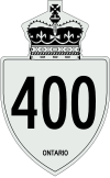
Highway markers take on one of three designs depending on their use. Standard road shields placed on the highway itself consist of the route number in black on a white shield design topped with a St Edward's Crown. In the current design, the highway number and the word "ONTARIO" appear on the shield. Signs prior to 1993 had the words "The King's Highway" below the crown, but current versions have the words removed. Older signs were made of ceramic and current of metal. Junction signs (used at intersections, ramp signs and on overhead signs non 400-series highways) use a white Silhouette of the St Edward's Crown with the route number in it. Trailblazer signs (those indicating a route "to" a highway) look like one of the first two but are green (with white lettering) instead of white.
The speed limit on King's Highways is generally 80 km/h (50 mph) in rural areas and 50 km/h (31 mph) in urban areas. On rural portions of the Trans-Canada Highway, on RIRO and at-grade expressways, and on certain other highways in Northern Ontario, the speed limit is 90 km/h (56 mph).
400-series Highways
400-series highways are a special class of provincial highways, being designed to be exclusively controlled-access freeways for the entire length of the highway. At present, all of them are located in Southern Ontario, where they form a network similar to the US Interstate Highways. The 400-series highways include Highways 400, 401, 402, 403, 404, 405, 406, 407, 409, 410, 412, 416, 417, 420, 427, and the Queen Elizabeth Way (QEW). Originally, 400-Series route numbers were assigned sequentially, but more recently new routes have been numbered based on the existing highway the new route bypassed or upgraded (Highway 427 being an upgrade of Highway 27, for example).
Although the province also maintains freeways that match 400-series standards, such as the Conestoga Parkway, they are not designated with a 400-series number, even though some of those freeways exceed some existing 400-series highways in size and traffic volume and are in some cases connected to the 400-series network. Nonetheless, Ontario freeways do not receive a 400-series number unless they are designed to be complete controlled-access freeways for their whole length. While at-grade intersections existed on Highway 406 for many years, construction took place from 2008 to 2015 to close off intersections or replace them with overpasses and interchanges, bringing the route to full freeway standards. The non 400-series routes typically have open-access portions besides the freeway section, with the freeway segment typically being a small section not at the route's termini. 400-series standards do allow for 400 series highways to begin/end at roundabouts or traffic lights, with examples of these being Highway 406 and Highway 420, respectively.
The 400-series highways are designed to the highest specifications of any provincial highways, with typical design speeds of 100–130 km/h. Nearly all 400-series highways have posted speeds of 100 km/h, although in a few instances, speeds are lower, usually to account for dangerous or obsolete-design areas. For example, Highway 403 near Hamilton is signed at 90 km/h because of a series of sharp curves, and Highway 402 is signed at 70 km/h on the final approach to the border crossing at the Blue Water Bridge in Sarnia because of heavy, backed-up or stopped truck traffic.
Secondary

Secondary highways exist in Northern Ontario (and used to exist in Central and Eastern Ontario) to connect towns and remote areas, often connecting small to large towns to major Kings Highways. These highways are currently numbered from 502 to 673. Secondary highway markers are trapezoid-shaped. On the face of the marker appear, from top to bottom: the Ontario coat of arms, the word "ONTARIO", and the number of the highway.
A few secondary highways remain gravel-surfaced, although most have been paved. The speed limit on nearly all of these routes is 80 km/h (50 mph), although Highway 655 is posted at 90 km/h (56 mph). The majority of length in the secondary highway system consists of a single continuous yellow centerline, though some segments are up to kings highway standards either because they serve as a quick connector to them (like Highway 655), or because they are former alignments of King's Highways, or because they approach an intersection with a King's Highway.
The Secondary Highway system was introduced in 1955 to service regions in Northern and Central Ontario, but parts of the system were decommissioned from the provincial highway network in 1997 and 1998. In Northern Ontario, where there is no county-level system of government to take over road maintenance, secondary highways are still in operation and serve a function analogous to that of a county road, while those in Southern Ontario have all been downloaded to the counties and rolled into the county road systems there.
Tertiary

Tertiary roads connect those regions in northern Ontario not served by secondary highways. Legally, "road" has the same meaning as highway.[1] These roads are currently numbered 801 to 811, and are marked by a simple rectangular marker with rounded corners bearing the number of the highway and the word "ONTARIO".
Most of these roads are gravel-surfaced and low-standard. The speed limit on these routes is 80 km/h (50 mph), although design standards generally override such.
The Ministry of Transportation introduced the Tertiary Road system in 1962. These roads were mostly resource access roads generally built into the most remote areas in Northern Ontario. These roads were constructed in small numbers, and with one exception (Highway 802), do not end at a settlement. Most of these Tertiary Roads were later upgraded and rebuilt to Secondary Highway standards. At present, there are only six tertiary roads in Ontario. All are gravel roads, except for Hwy 802 and Hwy 805, which both have some paved sections.
Others
In addition to these three classes of highways, the Ministry of Transportation maintains other roads, such as resource roads or industrial roads, that are of strategic importance to the Ministry, but which are not important enough to be given any special marking. These roads are designated with 7000-series numbers for internal inventory purposes, though they are not publicly marked as such. These are frequently, but not always, former highway segments which lost their original highway designation but remain important as connecting routes to communities or other highways.
As a further note, some roads are designated as 7000-series highways but are discontinuous, connected by "non-assumed" roads (roads not under provincial control, such as county roads, or town streets), linking both parts that share the same number.
Also, in Southern Ontario and in the city of Greater Sudbury there are systems of regional, municipal or county roads that are also numbered. These roads are maintained by the local government (Township, City, or County/Region), not by the province.
There are also several formerly designated Ontario Tourist Routes that were located throughout the entire province, but these have since become harder to find, as many signs have been taken down. There are also "Historic Colonization Roads" throughout eastern and central Ontario, shown on maps and on street signs. See List of Ontario Historic Colonization Roads for more information.
Transfers
On April 1, 1997, and January 1, 1998, the Ontario government under the leadership of Mike Harris transferred, or downloaded, several thousand kilometres of provincially maintained highways to the various municipalities in which they are located. These transfers were performed under the reasoning that they served a mostly local function, as a cost-saving measure and as part of a broader exchange of responsibilities between the province and its municipalities. The transfers continue to cause confusion to motorists due to gaps in the middle of several highways and unremoved reassurance markers in municipalities with former Connecting Link agreements, including Toronto, Ottawa and London.
1,767.6 kilometres (1,098.3 mi) of highway was removed from the King's Highway system on April 1, 1997. This was followed by 3,211.1 kilometres (1,995.3 mi) on January 1, 1998, for a total of 4,978.7 kilometres (3,093.6 mi).
See also
References
- 1 2 Public Transportation and Highway Improvement Act; R.S.O. 1990, Chapter P.50
- ↑ Highway Traffic Act; R.S.O. 1990, Chapter H.8
- ↑ Don W. Thompson (1969). Men and Meridians: The History of Surveying and Mapping in Canada. Volume 3: 1917 to 1947. Canadian Government Publishing Centre. p. 141. ISBN 0-660-00359-7.
- ↑ "Design Approved". The Globe. 1929-11-02. p. 2.
- ↑ Municipal Act, 2001; SO 2001, c. 25
- ↑ Provincially Maintained Highways
- ↑ Conservation Authorities Act; R.R.O. 1990, Regulation 164, Amended to O. Reg. 172/06
- 1 2 TheKingsHighway.ca
External links
| Wikimedia Commons has media related to Highways in Ontario. |
- Ministry of Transportation of Ontario (MTO)
- MTO news releases
- Official Ontario road map
- OntHighways.com at Asphaltplanet
- The King's Highway Ends

| Tertiary Highways | ||
|---|---|---|
| 7000-series Highways | ||
| Other | ||
| ||
|