Charmwood, Missouri
| Charmwood, Missouri | |
|---|---|
| Town | |
| Country | United States |
| State | Missouri |
| County | Franklin |
| Area[1] | |
| • Total | 0.14 sq mi (0.4 km2) |
| • Land | 0.14 sq mi (0.4 km2) |
| • Water | 0 sq mi (0 km2) |
| Population | |
| • Total | 32 |
| • Estimate (2014) | 32 |
| • Density | 3,308.9/sq mi (1,277.6/km2) |
| Time zone | Central (CST) (UTC-6) |
| • Summer (DST) | CDT (UTC-5) |
| ZIP code | 63079[2] |
| FIPS code | 29-13390[1] |
Charmwood is a town in Franklin County, Missouri, United States. The population was estimated at 32 in 2014. The town was incorporated as a result of issues with the Charmwood Subdivision's water and sewer systems. Incorporation allowed the new town to apply for grants from the USDA to upgrade these systems.
Geography
Charmwood is located at (38.281033, -91.096767).[1]
According to the United States Census Bureau, the city has a total area of 0.14 square miles (0.36 km2), all of it land.[1]
Demographics
| Historical population | |||
|---|---|---|---|
| Census | Pop. | %± | |
| Est. 2015 | 32 | [3] | |
References
- 1 2 3 4 "US Gazetteer files 2014". United States Census Bureau. Retrieved 2012-07-08.
- ↑ Fritschle, Evin (3 Oct 2010). "New Town of Charmwood Formed in Stanton Area". The Missourian. Retrieved 22 July 2015.
- ↑ "Annual Estimates of the Resident Population for Incorporated Places: April 1, 2010 to July 1, 2015". Retrieved July 2, 2016.
- ↑ "Census of Population and Housing". Census.gov. Archived from the original on May 11, 2015. Retrieved June 4, 2015.
External links
Municipalities and communities of Franklin County, Missouri, United States | ||
|---|---|---|
| Cities | 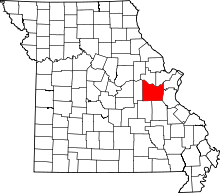 | |
| Villages | ||
| Townships | ||
| CDPs | ||
| Other unincorporated communities |
| |
| Ghost towns | ||
| Footnotes | ‡This populated place also has portions in an adjacent county or counties | |
Coordinates: 38°16′46″N 91°05′55″W / 38.27944°N 91.09861°W
This article is issued from Wikipedia - version of the 11/20/2016. The text is available under the Creative Commons Attribution/Share Alike but additional terms may apply for the media files.