Champigny-en-Beauce
| Champigny-en-Beauce | |
|---|---|
|
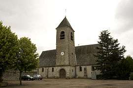
Church of Saint-Félix | |
 Champigny-en-Beauce | |
|
Location within Centre-Val de Loire region  Champigny-en-Beauce | |
| Coordinates: 47°42′46″N 1°15′24″E / 47.7128°N 1.2567°ECoordinates: 47°42′46″N 1°15′24″E / 47.7128°N 1.2567°E | |
| Country | France |
| Region | Centre-Val de Loire |
| Department | Loir-et-Cher |
| Arrondissement | Blois |
| Canton | Herbault |
| Intercommunality | Beauce - Val de Cisse |
| Government | |
| • Mayor (2014–2020) | Serge Guimard |
| Area1 | 22.31 km2 (8.61 sq mi) |
| Population (2013)2 | 592 |
| • Density | 27/km2 (69/sq mi) |
| Time zone | CET (UTC+1) |
| • Summer (DST) | CEST (UTC+2) |
| INSEE/Postal code | 41035 / 41330 |
| Elevation |
92–129 m (302–423 ft) (avg. 119 m or 390 ft) |
|
1 French Land Register data, which excludes lakes, ponds, glaciers > 1 km² (0.386 sq mi or 247 acres) and river estuaries. 2 Population without double counting: residents of multiple communes (e.g., students and military personnel) only counted once. | |
Champigny-en-Beauce is a commune in the Loir-et-Cher department in central France.
Population
| Historical population | ||
|---|---|---|
| Year | Pop. | ±% |
| 1793 | 635 | — |
| 1806 | 619 | −2.5% |
| 1821 | 648 | +4.7% |
| 1831 | 747 | +15.3% |
| 1841 | 692 | −7.4% |
| 1851 | 709 | +2.5% |
| 1861 | 748 | +5.5% |
| 1872 | 793 | +6.0% |
| 1881 | 782 | −1.4% |
| 1891 | 771 | −1.4% |
| 1901 | 697 | −9.6% |
| 1911 | 653 | −6.3% |
| 1921 | 552 | −15.5% |
| 1931 | 603 | +9.2% |
| 1946 | 622 | +3.2% |
| 1954 | 572 | −8.0% |
| 1962 | 507 | −11.4% |
| 1968 | 462 | −8.9% |
| 1975 | 438 | −5.2% |
| 1982 | 472 | +7.8% |
| 1990 | 481 | +1.9% |
| 1999 | 553 | +15.0% |
| 2008 | 653 | +18.1% |
| 2013 | 592 | −9.3% |
See also
References
| Wikimedia Commons has media related to Champigny-en-Beauce. |
This article is issued from Wikipedia - version of the 11/10/2016. The text is available under the Creative Commons Attribution/Share Alike but additional terms may apply for the media files.