La Fontenelle, Loir-et-Cher
| La Fontenelle | ||
|---|---|---|
|
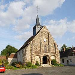
Church of Saint-Loup-Saint-Gilles | ||
| ||
 La Fontenelle | ||
|
Location within Centre-Val de Loire region  La Fontenelle | ||
| Coordinates: 48°03′39″N 1°01′30″E / 48.0608°N 1.025°ECoordinates: 48°03′39″N 1°01′30″E / 48.0608°N 1.025°E | ||
| Country | France | |
| Region | Centre-Val de Loire | |
| Department | Loir-et-Cher | |
| Arrondissement | Vendôme | |
| Canton | Droué | |
| Intercommunality | Perche vendômois | |
| Government | ||
| • Mayor (2014–2020) | Joël Verdier | |
| Area1 | 20.1 km2 (7.8 sq mi) | |
| Population (2013)2 | 196 | |
| • Density | 9.8/km2 (25/sq mi) | |
| Time zone | CET (UTC+1) | |
| • Summer (DST) | CEST (UTC+2) | |
| INSEE/Postal code | 41089 / 41270 | |
| Elevation |
156–202 m (512–663 ft) (avg. 185 m or 607 ft) | |
|
1 French Land Register data, which excludes lakes, ponds, glaciers > 1 km² (0.386 sq mi or 247 acres) and river estuaries. 2 Population without double counting: residents of multiple communes (e.g., students and military personnel) only counted once. | ||
.svg.png)
La Fontenelle is a commune in the Loir-et-Cher department of central France.
Population
| Historical population | ||
|---|---|---|
| Year | Pop. | ±% |
| 1793 | 695 | — |
| 1806 | 701 | +0.9% |
| 1821 | 708 | +1.0% |
| 1831 | 777 | +9.7% |
| 1841 | 834 | +7.3% |
| 1851 | 840 | +0.7% |
| 1861 | 769 | −8.5% |
| 1872 | 675 | −12.2% |
| 1881 | 642 | −4.9% |
| 1891 | 606 | −5.6% |
| 1901 | 636 | +5.0% |
| 1911 | 656 | +3.1% |
| 1921 | 606 | −7.6% |
| 1931 | 528 | −12.9% |
| 1946 | 481 | −8.9% |
| 1954 | 461 | −4.2% |
| 1962 | 409 | −11.3% |
| 1968 | 364 | −11.0% |
| 1975 | 297 | −18.4% |
| 1982 | 218 | −26.6% |
| 1990 | 208 | −4.6% |
| 1999 | 185 | −11.1% |
| 2008 | 187 | +1.1% |
| 2013 | 196 | +4.8% |
See also
References
| Wikimedia Commons has media related to La Fontenelle (Loir-et-Cher). |
This article is issued from Wikipedia - version of the 11/26/2016. The text is available under the Creative Commons Attribution/Share Alike but additional terms may apply for the media files.