Cascadia subduction zone

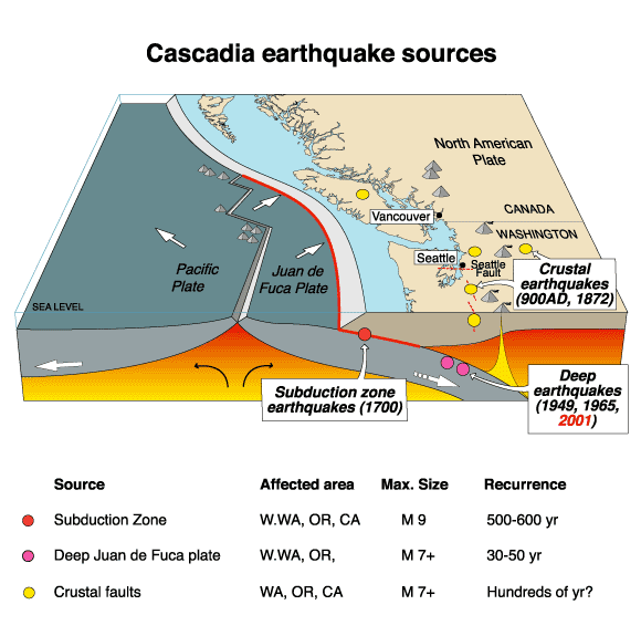
Coordinates: 45°N 124°W / 45°N 124°W The Cascadia subduction zone (also referred to as the Cascadia fault) is a convergent plate boundary that stretches from northern Vancouver Island to northern California. It is a very long, sloping subduction zone that separates the Explorer, Juan de Fuca, and Gorda plates, on the one hand, and the North American Plate, on the other.
The denser oceanic plate is subducting beneath the less dense continental plate offshore of British Columbia, Washington, Oregon, and northern California. The North American Plate moves in a general southwest direction, overriding the oceanic plate. The Cascadia subduction zone is where the two plates meet.
Tectonic processes active in the Cascadia subduction zone region include accretion, subduction, deep earthquakes, and active volcanism of the Cascades. This volcanism has included such notable eruptions as Mount Mazama (Crater Lake) about 7,500 years ago, Mount Meager about 2,350 years ago, and Mount St. Helens in 1980.[1] Major cities affected by a disturbance in this subduction zone would include Vancouver and Victoria, British Columbia; Seattle, Washington; and Portland, Oregon.
History
In the 1960s, underground fractures were uncovered by oil companies in Puget Sound. These were believed to be inactive through the 1990s.[2]
In the 1980s, geophysicists Tom Heaton and Hiroo Kanamori of Caltech compared the generally quiet Cascadia to more active subduction zones elsewhere in the Ring of Fire. They found similarities to faults in Chile, Alaska, and Japan's Nankai Trough, locations known for megathrust earthquakes, a conclusion that was met with skepticism from other geophysicists at the time.[3]
Oral history
At the time of the 1700 earthquake, there were no written records of the event in Cascadia. Orally-transmitted legends from the Olympic Peninsula area talk of an epic battle between a thunderbird and a whale. Therefore, in a 2005 study, seismologist Ruth Ludwin set out to collect and analyze anecdotes from various First Nations groups. Reports from the Huu-ay-aht,[4] Makah,[4] Hoh,[5] Quileute,[2][5] Yurok,[2] and Duwamish[2] peoples referred to earthquakes and saltwater floods. This collection of data allowed her team to come up with an estimated date range for the event, whose midpoint fell in the year 1701.[4]
Ghost forests
During low tide one day in March 1986, paleogeologist Brian Atwater dug along Neah Bay using a nejiri gama, a small hand hoe. Underneath the top layer of sand, he uncovered a distinct plant—arrowgrass—that had grown in a layer of marsh soil. This was proof that the ground had suddenly sunk under sea level, causing saltwater to kill the vegetation. The events had happened so quickly as to cause the top layer of sand to seal away any air, thus preserving the centuries-old plants.[3]
In 1987, Atwater mounted another expedition paddling up the Copalis River with Dr. David Yamaguchi, who was then studying the eruptions of Mount St. Helens.[3] The pair happened upon a section of "ghost forest," so-called due to the dead, gray stumps left standing after a sudden inundation of salt water had killed them hundreds of years ago.[5] Originally thought to have died slowly due to a gradual rise in sea level,[6] closer inspection yielded a different story: the land plummeted up to two meters during an earthquake.[5] Having initially tested spruce using tree-ring dating, they found that the stumps were too rotted to count all the outer rings. However, upon having examined those of the western red cedar and comparing them to the living specimens meters away from the banks, they were able to approximate their year of death. There were rings up until the year 1690, indicating that the incident had occurred shortly thereafter. Root samples confirmed their conclusion, narrowing the time frame to the winter of 1699 to 1700.[3][4]
As with the arrowgrass site, the banks of the Copalis River are lined with a layer of marsh followed by a layer of sand. Jody Bourgeois and her team went on to demonstrate that the sand cover had originated with a tsunami surge rather than a storm surge.[5]
In 1995, an international team led by Alan Nelson of the USGS further corroborated these findings with 85 new samples from the rest of the Pacific Northwest. All along British Columbia, Washington State, and Oregon, the coast had fallen due to a violent earthquake and been covered by sand from the subsequent tsunami.[3]
Yet another ghost forest was identified by Gordon Jacoby, a dendrochronologist from Columbia University, 60 feet (18 m) underwater in Lake Washington. Unlike the other trees, these suffered from a landslide rather than a dip in the fault during a separate event around 900 CE.[2]
Orphan tsunami
A 1996 study published by seismologist Kenji Satake supplemented the research by Atwater et al. with tsunami evidence across the Pacific.[4] Japanese annals, which have recorded natural disasters since approximately 600 CE,[6] had reports of a sixteen-foot tsunami that struck the coast of Honshu Island during the Genroku.[3][4] Since no earthquake had been observed to produce it, scholars dubbed it an "orphan tsunami."[6] Translating the Japanese calendar, Satake found the incident had taken place around midnight of 27–28 January 1700, ten hours after the earthquake.
Geology

The Cascadia Subduction Zone (CSZ) is a 1,000 km (620 mi) long dipping fault that stretches from Northern Vancouver Island to Cape Mendocino in northern California. It separates the Juan de Fuca and North America plates. New Juan de Fuca plate is created offshore along the Juan de Fuca Ridge.[7][8]
The Juan de Fuca plate moves toward, and eventually is shoved beneath, the continent (North American plate). The zone separates the Juan de Fuca Plate, Explorer Plate, Gorda Plate, and North American Plate. Here, the oceanic crust of the Pacific Ocean has been sinking beneath the continent for about 200 million years, and currently does so at a rate of approximately 40 mm/yr.[7][8]
At depths shallower than 30 km (19 mi) or so, the CSZ is locked by friction while strain slowly builds up as the subduction forces act, until the fault's frictional strength is exceeded and the rocks slip past each other along the fault in a megathrust earthquake. Below 30 km (19 mi) the plate interface exhibits episodic tremor and slip.
The width of the Cascadia subduction zone varies along its length, depending on the angle of the subducted oceanic plate, which heats up as it is pushed deeper beneath the continent. As it becomes hotter and more molten, it eventually loses the ability to store mechanical stress and generate earthquakes. On the Hyndman and Wang diagram (not shown, click on reference link below) the "locked" zone is storing up energy for an earthquake, and the "transition" zone, although somewhat plastic, could probably rupture.[9]
The Cascadia subduction zone runs from triple junctions at its north and south ends. To the north, just below Haida Gwaii, it intersects the Queen Charlotte Fault and the Explorer Ridge. To the south, just off of Cape Mendocino in California, it intersects the San Andreas Fault and the Mendocino Fracture Zone at the Mendocino Triple Junction.
Earthquakes
Earthquake effects
Megathrust earthquakes are the most powerful earthquakes known to occur, and can exceed magnitude 9.0. They occur when enough energy (stress) has accumulated in the "locked" zone of the fault to cause a rupture known as a megathrust earthquake. The magnitude of a megathrust earthquake is proportional to length of the rupture along the fault. The Cascadia Subduction Zone, which forms the boundary between the Juan de Fuca and North American plates, is a very long sloping fault that stretches from mid-Vancouver Island to Northern California.[10]
Because of the great length of the fault, the Cascadia Subduction Zone is capable of producing very large earthquakes if rupture occurs along its entire length. Thermal and deformation studies indicate that the region 60 kilometers (about 40 miles) downdip (east) of the deformation front (where plate deformation begins) is fully locked (the plates do not move past each other). Further downdip, there is a transition from fully locked to aseismic sliding.[10]
In 1999, a group of Continuous Global Positioning System sites registered a brief reversal of motion of approximately 2 centimeters (0.8 inches) over a 50 kilometer by 300 kilometer (about 30 mile by 200 mile) area. The movement was the equivalent of a 6.7 magnitude earthquake.[11] The motion did not trigger an earthquake and was only detectable as silent, non-earthquake seismic signatures.[12]
In 2004, a study conducted by the Geological Society of America analyzed the potential for land subsidence along the Cascadia subduction zone. It postulated that several towns and cities on the west coast of Vancouver Island, such as Tofino and Ucluelet, are at risk for a sudden, earthquake initiated, 1–2 m subsidence.[13]
San Andreas Fault connection
Studies of past earthquake traces on both the northern San Andreas Fault and the southern Cascadia subduction zone indicate a correlation in time which may be evidence that quakes on the Cascadia subduction zone may have triggered most of the major quakes on the northern San Andreas during at least the past 3,000 years or so. The evidence also shows the rupture direction going from north to south in each of these time-correlated events. The 1906 San Francisco earthquake seems to have been a major exception to this correlation, however, as it was not preceded by a major Cascadia quake.[14]
Earthquake timing
| estimated year | interval | |
|---|---|---|
| 2005 source[15] | 2003 source[16] | (years) |
| about 9 pm, January 26, 1700 (NS) | 780 | |
| 780-1190 CE | 880-960 CE | 210 |
| 690-730 CE | 550-750 CE | 330 |
| 350-420 CE | 250-320 CE | 910 |
| 660-440 BCE | 610-450 BCE | 400 |
| 980-890 BCE | 910-780 BCE | 250 |
| 1440-1340 BCE | 1150-1220 BCE | unknown |
The last known great earthquake in the northwest was the 1700 Cascadia earthquake. Geological evidence indicates that great earthquakes (> magnitude 8.0) may have occurred sporadically at least seven times in the last 3,500 years, suggesting a return time of about 500 years.[3][4][5] Seafloor core evidence indicates that there have been forty-one subduction zone earthquakes on the Cascadia subduction zone in the past 10,000 years, suggesting a general average earthquake recurrence interval of only 243 years.[6] Of these 41, nineteen have produced a "full margin rupture," wherein the entire fault opens up.[3] By comparison, similar subduction zones in the world usually have such earthquakes every 100 to 200 years; the longer interval here may indicate unusually large stress buildup and subsequent unusually large earthquake slip.[17]
There is also evidence of accompanying tsunamis with every earthquake. One strong line of evidence for these earthquakes is convergent timings for fossil damage from tsunamis in the Pacific Northwest and historical Japanese records of tsunamis.[18]
The next rupture of the Cascadia Subduction Zone is anticipated to be capable of causing widespread destruction throughout the Pacific Northwest.[19]
Forecasts of the next major earthquake
Prior to the 1980s, scientists thought that the subduction zone just did not generate earthquakes like the other subduction zones around the world, but research by Brian Atwater and Kenji Satake tied together evidence of a large tsunami on the Washington coast with documentation of an orphan tsunami in Japan (a tsunami without an associated earthquake). The two pieces of the puzzle were linked, and they then realized that the subduction zone was more hazardous than previously suggested.
In 2009, some geologists predicted a 10% to 14% probability that the Cascadia Subduction Zone will produce an event of magnitude 9.0 or higher in the next 50 years.[20] In 2010, studies suggested that the risk could be as high as 37% for earthquakes of magnitude 8.0 or higher[21][22]
Geologists and civil engineers have broadly determined that the Pacific Northwest region is not well prepared for such a colossal earthquake. The earthquake is expected to be similar to the 2011 Tōhoku earthquake and tsunami, because the rupture is expected to be as long as the 2004 Indian Ocean earthquake and tsunami. The resulting tsunami might reach heights of approximately 30 meters (100 ft).[20] FEMA estimates some 13,000 fatalities from such an event, with another 27,000 injured. It predicts that a million people will be displaced, with yet another 2.5 million requiring food and water. An estimated 1/3 of public safety workers will not respond to the disaster due to a collapse in infrastructure and a desire to ensure the safety of themselves and their loved ones.[6] Other analyses predict that even a magnitude 6.7 earthquake in Seattle would result in 7,700 dead and injured, $33 billion in damages, 39,000 buildings largely or totally destroyed, and 130 simultaneous fires.[2]
Cascade Volcanic Arc
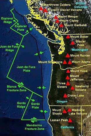
The Cascade Volcanic Arc is a continental volcanic arc that extends from northern California to the coastal mountains of British Columbia.[1] The arc consists of a series of Quaternary age stratovolcanoes that grew on top of pre-existing geologic materials that ranged from Miocene volcanics to glacial ice.[1] The Cascade Volcanic arc is located approximately 100 km inland from the coast, and forms a north-to-south chain of peaks that average over 3,000 m (10,000 ft) in elevation.[1] The major peaks from south to north include:
- Lassen Peak and Mt. Shasta (California)
- Crater Lake (Mazama), Three Sisters, Mt. Jefferson, Mt. Hood (Oregon)
- Mt. Adams, Mount St. Helens, Mt. Rainier, Glacier Peak, Mt. Baker (Washington)
- Mt. Garibaldi and Mt. Meager (British Columbia)
The most active volcanoes in the chain include Mount St. Helens, Mt. Baker, Lassen Peak, and Mt. Hood. St. Helens captured worldwide attention when it erupted catastrophically in 1980.[1] St. Helens continues to rumble, albeit more quietly, emitting occasional steam plumes and experiencing small earthquakes, both signs of continuing magmatic activity.[1]
Most of the volcanoes have a main, central vent from which the most recent eruptions have occurred. The peaks are composed of layers of solidified andesitic to dacitic magma, and the more siliceous (and explosive) rhyolite.
The volcanoes above the subduction zone include:
See also
- Cascade Range
- Cascade Volcanoes
- Cascadia (disambiguation)
- Geology of the Pacific Northwest
- Neskowin Ghost Forest
- North Cascades National Park
- Plate tectonics
References
- 1 2 3 4 5 6 "Cascadia Subduction Zone Volcanism in British Columbia". Archived from the original on 2010-06-02. Retrieved 2008-12-18. USGS
- 1 2 3 4 5 6 Kevin Krajick (March 2005). "Future Shocks: Modern science, ancient catastrophes and the endless quest to predict earthquakes". Smithsonian Magazine. Retrieved 15 July 2015.
- 1 2 3 4 5 6 7 8 Jerry Thompson (13 March 2012). "The Giant, Underestimated Earthquake Threat to North America". Discover Magazine. Retrieved 15 July 2015.
- 1 2 3 4 5 6 7 Stefan Lovgren (8 December 2003). "Did North American Quake Cause 1700 Japanese Tsunami?". National Geographic. Retrieved 15 July 2015.
- 1 2 3 4 5 6 "Ghosts of Tsunamis Past". American Museum of Natural History. Retrieved 15 July 2015.
- 1 2 3 4 5 Schulz, Kathryn (July 20, 2015). "The Really Big One: An earthquake will destroy a sizable portion of the coastal Northwest. The question is when.". The New Yorker. Retrieved July 14, 2015.
- 1 2 "Juan de Fuca Volcanics". Retrieved 2008-05-06. USGS
- 1 2 Alt, David D.; Hyndman, Donald W. (1978). Roadside Geology of Oregon (19th ed.). Missoula, Montana: Mountain Press. p. 3. ISBN 0-87842-063-0.
- ↑ "Hyndman and Wang". Archived from the original on 2010-05-30. Retrieved 2009-12-17. USGS (dead link) See fig. 5 here for the diagram.
- 1 2 Nedimović, Mladen R.; Hyndman, Roy D.; Ramachandran, Kumar; Spence, George D. (24 July 2003). "Reflection signature of seismic and aseismic slip on the northern Cascadia subduction interface". Nature. 424 (6947): 416–420. Bibcode:2003Natur.424..416N. doi:10.1038/nature01840. PMID 12879067.
- ↑ Dragert, Herb; Wang, Kelin; James, Thomas S. (25 May 2001). "A silent slip event on the deeper Cascadia subduction interface". Science. 292 (5521): 1525–1528. Bibcode:2001Sci...292.1525D. doi:10.1126/science.1060152. PMID 11313500.
- ↑ Rogers, Garry; Dragert, Herb (20 June 2003). "Episodic tremor and slip on the Cascadia subduction zone: the chatter of silent slip". Science. 300 (5627): 1942–1943. Bibcode:2003Sci...300.1942R. doi:10.1126/science.1084783. PMID 12738870.
- ↑ Leonard, Lucinda J.; Hyndman, Roy D.; Mazzotti, Stéphane. "Coseismic subsidence in the 1700 great Cascadia earthquake: Coastal estimates versus elastic dislocation models". GSA Bulletin. 116 (5–6): 655–670. Bibcode:2004GSAB..116..655L. doi:10.1130/B25369.1.
- ↑ Science Daily, April 3, 2008
- ↑ Brian F Atwater; Musumi-Rokkaku Satoko; Satake Kenji; Tsuji Yoshinobu; Ueda Kazue; David K Yamaguchi (2005). The Orphan Tsunami of 1700 — Japanese Clues to a Parent Earthquake in North America (PDF) (U.S. Geological Survey Professional Paper 1707 ed.). Seattle and London: University of Washington Press. p. 100 (timeline diagram). ISBN 0-295-98535-6.
- ↑ Brian F Atwater; Martitia P Tuttle; Eugene S Schweig; Charles M Rubin; David K Yamaguchi; Eileen Hemphill-Haley (2003). "Earthquake Recurrence Inferred from Paleoseismology" (PDF). Developments in Quaternary Science. Elsevier BV. 1. Figures 10 and 11 (pp 341, 342); article pp 331-350. doi:10.1016/S1571-0866(03)01015-7. ISSN 1571-0866. Archived from the original (PDF) on 2012-03-19. Retrieved 2011-03-15.
- ↑ "Cascadia Subduction Zone". Pacific Northwest Seismic Network.
- ↑ "The Orphan Tsunami of 1700—Japanese Clues to a Parent Earthquake in North America" (PDF). Retrieved 2008-05-06. USGS Professional Paper 1707
- ↑ "Cascade Range Earthquake Workgroup - Magnitude 9 scenario" (PDF).
- 1 2 Tobias, Lori (April 19, 2009). "Big earthquake coming sooner than we thought, Oregon geologist says". The Oregonian.
- ↑ Lovett, Richard A. (31 May 2010). "Risk of giant quake off American west coast goes up". Nature. doi:10.1038/news.2010.270. Retrieved 2010-06-08.
- ↑ "Odds are about 1-in-3 that mega-earthquake will hit Pacific Northwest in next 50 years, scientists say" (Press release). Oregon State University. May 25, 2010 – via Science Daily.
External links
- Chris Goldfinger; C. Hans Nelson; Ann E. Morey; Joel E. Johnson; Jason R. Patton; Eugene Karabanov; Julia Gutiérrez-Pastor; Andrew T. Eriksson; Eulàlia Gràcia; Gita Dunhill; Randolph J. Enkin; Audrey Dallimore; Tracy Vallier (2012). Robert Kayen, ed. "Turbidite event history—Methods and implications for Holocene paleoseismicity of the Cascadia subduction zone". U.S. Geological Survey. Professional Paper 1661–F.
- Atwater, BF (1987). "Evidence for great Holocene earthquakes along the outer coast of Washington State". Science. 236 (4804): 942–44. Bibcode:1987Sci...236..942A. doi:10.1126/science.236.4804.942. PMID 17812748.
- "Cascadia Peril '09" at dailywireless.org
- 9.0 Shakemap Scenario
- The Really Big One – University of California Television
- Great Earthquakes of the Pacific Northwest – Central Washington University