Wasatch Fault
- Not to be confused with the Wasatch Front

The Wasatch Fault is an active fault located primarily on the western edge of the Wasatch Mountains in the U.S. state of Utah. The fault is 240 miles (390 kilometres) long, stretching from southern Idaho, through northern Utah, before terminating in central Utah near the town of Fayette.[1] It is made up of several segments, on average 25 miles (40 kilometres) long, each of which can independently produce earthquakes as powerful as local magnitude 7.5.
The Wasatch Fault is a normal (vertical motion) fault which forms the eastern boundary of the Basin and Range geologic province which comprises the geographic Great Basin. The Wasatch Mountains have been uplifted and tilted to the east by movement of the fault. The average rate of uplift along the fault over its history is approximately 1 millimetre (0.04 in) per year, although there are indications that more rapid slip has occurred in the past few thousand years. The fault, however, does not continually slowly slip; instead, it remains locked for hundreds to thousands of years until approximately 1 to 4 metres (3 to 13 feet) of slip occurs rapidly, producing a strong earthquake.
Geological history
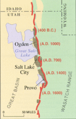
During the past 6,000 years, a strong earthquake (magnitude greater than 6.5) has occurred approximately once every 350 years somewhere along one of the central segments of the Wasatch Fault. The segments that underlie Salt Lake City and Provo produce a large earthquake on average every 1,300 years. The last major earthquake on the Salt Lake City segment was about 1,300 years ago, and on adjoining segments around 2,100 years ago. Experts note that the fault is overdue for another major earthquake, and media coverage of the threat has increased in recent years, bringing greater awareness of the threat to residents of the region. As awareness has increased since the 1980s, many key structures in the region have been undergoing extensive seismic retrofitting, reservoirs on the fault have been drained, and development in at-risk areas curtailed.[2] The urban areas of the Wasatch Front lie on soft lake sediments, a remnant of Lake Bonneville. An earthquake on the Wasatch Fault could severely damage gas, electric, water, communication, and transportation lifelines, crippling the 2,000,000-plus Wasatch Front urban area.[3]
A recent report released by Bob Carey of Utah's Office of Emergency Services and published by the Deseret News in April 2006 predicts what the possible results of a 7.0 earthquake directly hitting the Salt Lake Valley could be. The report predicts that when the quake strikes, it could kill up to 6,200 people, injure at least 90,000, and cause US$40 billion in economic losses. At least 42% of all buildings along the Wasatch Front could be at least moderately damaged. The earthquake danger was not known when many structures were built in the area, as many hospitals and schools are located atop the faults themselves. About 50% of hospital beds could be eliminated during a quake and the region has about 200,000 unreinforced masonry buildings – buildings particularly vulnerable to shaking – compared to California's 25,000. Massive landslides are another major threat.[4]
References
- ↑ UGS/USGS Wasatch Fault Study
- ↑ Utah Geological Survey
- ↑ USGS USGS: Intermountain West
- ↑ Deseret News article
External links
- Utah Geological Survey Public Information Series 40: The Wasatch Fault
- Utah Geological Survey presentation about the fault