Carney, Montana
| Carney, Montana | |
|---|---|
| Unincorporated community | |
 Carney, Montana  Carney, Montana | |
| Coordinates: 45°45′55″N 110°07′26″W / 45.76528°N 110.12389°WCoordinates: 45°45′55″N 110°07′26″W / 45.76528°N 110.12389°W | |
| Country | United States |
| State | Montana |
| County | Sweet Grass |
| Elevation | 4,153 ft (1,266 m) |
| Time zone | Mountain (MST) (UTC-7) |
| • Summer (DST) | MDT (UTC-6) |
| Area code(s) | 406 |
| GNIS feature ID | 806913[1] |
Carney is an unincorporated community in Sweet Grass County, Montana, United States. Carney is located along Interstate 90 southwest of Big Timber.
History
Carney was a stop on the Northern Pacific railway situated on Interstate 90 about eight miles southwest of Big Timber. It once had a depot and an elevator that supported nearby ranches and a small community. The ranches are still present but the town is no longer.
References
- ↑ "US Board on Geographic Names". United States Geological Survey. 2007-10-25. Retrieved 2008-01-31.
Municipalities and communities of Sweet Grass County, Montana, United States | ||
|---|---|---|
| City | 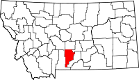 | |
| CDP | ||
| Unincorporated communities | ||
This article is issued from Wikipedia - version of the 8/8/2016. The text is available under the Creative Commons Attribution/Share Alike but additional terms may apply for the media files.