Capps, Alabama
| Capps, Alabama | |
|---|---|
| Unincorporated community | |
 Capps, Alabama  Capps, Alabama | |
| Coordinates: 31°29′50″N 85°18′43″W / 31.49722°N 85.31194°WCoordinates: 31°29′50″N 85°18′43″W / 31.49722°N 85.31194°W | |
| Country | United States |
| State | Alabama |
| County | Henry |
| Elevation | 423 ft (129 m) |
| Time zone | Central (CST) (UTC-6) |
| • Summer (DST) | CDT (UTC-5) |
| Area code(s) | 334 |
| GNIS feature ID | 115606[1] |
Capps, also known as Choctawhatchee, is an unincorporated community in Henry County, Alabama, United States. Capps is located on Alabama State Route 173, 7.2 miles (11.6 km) southeast of Abbeville.
History
Capps is named after Daniel W. Capps, the community's first postmaster.[2] A post office operated under the name Capps from 1849 to 1972.[3] Capps served as a shipping point for agricultural products between Abbeville and Headland.[4]
References
- ↑ "Capps". Geographic Names Information System. United States Geological Survey.
- ↑ Foscue, Virginia (1989). Place Names in Alabama. Tuscaloosa: The University of Alabama Press. p. 28. ISBN 0-8173-0410-X.
- ↑ "Henry County". Jim Forte Postal History. Retrieved 1 August 2015.
- ↑ Milton Whitney; United States. Dept. of Agriculture; United States. Bureau of Soils (1911). Field operations of the Bureau of Soils. Bureau of Soils. p. 485.
Municipalities and communities of Henry County, Alabama, United States | ||
|---|---|---|
| Cities | 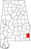 | |
| Towns | ||
| Unincorporated communities | ||
| Footnotes | ‡This populated place also has portions in an adjacent county or counties | |
This article is issued from Wikipedia - version of the 10/21/2016. The text is available under the Creative Commons Attribution/Share Alike but additional terms may apply for the media files.