Capels, West Virginia
| Capels | |
|---|---|
| Unincorporated community | |
|
Coal tipple in Capels, 1938. Photo by Marion Post Wolcott. | |
 Capels  Capels Location within the state of West Virginia | |
| Coordinates: 37°27′16″N 81°36′5″W / 37.45444°N 81.60139°WCoordinates: 37°27′16″N 81°36′5″W / 37.45444°N 81.60139°W | |
| Country | United States |
| State | West Virginia |
| County | McDowell |
| Elevation | 1,309 ft (399 m) |
| Time zone | Eastern (EST) (UTC-5) |
| • Summer (DST) | EDT (UTC-4) |
| ZIP codes | 24820 |
| GNIS feature ID | 1554065[1] |

Capels is an unincorporated community on the Tug Fork River in McDowell County, West Virginia, United States.
Capels most likely was named after the local Capel family.[2]
References
- ↑ U.S. Geological Survey Geographic Names Information System: Capels, West Virginia
- ↑ Kenny, Hamill (1945). West Virginia Place Names: Their Origin and Meaning, Including the Nomenclature of the Streams and Mountains. Piedmont, WV: The Place Name Press. p. 153.
Municipalities and communities of McDowell County, West Virginia, United States | ||
|---|---|---|
| Cities | 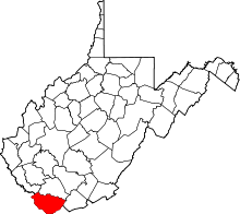 | |
| Towns | ||
| CDPs | ||
| Unincorporated communities |
| |
| Ghost town | ||
| Footnotes | ‡This populated place also has portions in an adjacent county or counties | |
This article is issued from Wikipedia - version of the 7/28/2016. The text is available under the Creative Commons Attribution/Share Alike but additional terms may apply for the media files.