Canaan (CDP), Vermont
| Canaan, Vermont | |
|---|---|
| Census-designated place | |
 Canaan | |
| Coordinates: 44°59′58″N 71°32′20″W / 44.99944°N 71.53889°WCoordinates: 44°59′58″N 71°32′20″W / 44.99944°N 71.53889°W | |
| Country | United States |
| State | Vermont |
| County | Essex |
| Town | Canaan |
| Area[1] | |
| • Total | 1.63 sq mi (4.22 km2) |
| • Land | 1.58 sq mi (4.10 km2) |
| • Water | 0.05 sq mi (0.12 km2) |
| Elevation | 1,043 ft (318 m) |
| Population (2010)[1] | |
| • Total | 392 |
| • Density | 248/sq mi (95.6/km2) |
| Time zone | Eastern (EST) (UTC-5) |
| • Summer (DST) | EDT (UTC-4) |
| ZIP code | 05901, 05903[2] |
| Area code(s) | 802 |
| GNIS feature ID | 1456760[3] |
| FIPS code | 50-11725 |
Canaan is a census-designated place comprising the main settlement in the town of Canaan, Essex County, Vermont, United States. As of the 2010 census, it had a population of 392,[1] out of a total town population of 972.
The Canaan CDP is in the northeast part of the town of Canaan and is bordered by Leach Creek to the west, the Connecticut River to the southeast, the community of Beecher Falls, Vermont, to the east, and the Canadian province of Quebec to the north. The community of West Stewartstown, New Hampshire, is to the southeast, across the Connecticut River. Beecher Falls to the east is the northeasternmost community in Vermont.
The Canaan CDP has a total area of 1.6 square miles (4.2 km2), of which 1.6 square miles (4.1 km2) is land and 0.046 square miles (0.12 km2), or 2.87%, is water.[1]
References
- 1 2 3 4 "Geographic Identifiers: 2010 Census Summary File 1 (G001): Canaan CDP, Vermont". American Factfinder. U.S. Census Bureau. Retrieved April 8, 2016.
- ↑ United States Postal Service (2016). "USPS - Look Up a ZIP Code". Retrieved April 8, 2016.
- ↑ "Canaan". Geographic Names Information System. United States Geological Survey.
Municipalities and communities of Essex County, Vermont, United States | ||
|---|---|---|
| Towns | 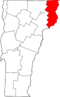 | |
| CDPs | ||
| Grants and gores | ||
| Footnotes | ‡ Unorganized | |