Caltanissetta
| Caltanissetta | ||
|---|---|---|
| Comune | ||
| Comune di Caltanissetta | ||
|
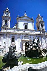
Caltanissetta Cathedral and the Triton Fountain, located in Piazza Garibaldi, the city's central square | ||
| ||
.svg.png) Caltanissetta within its province | ||
 Caltanissetta Location of Caltanissetta in Italy | ||
| Coordinates: 37°29′25″N 14°03′45″E / 37.49028°N 14.06250°ECoordinates: 37°29′25″N 14°03′45″E / 37.49028°N 14.06250°E | ||
| Country | Italy | |
| Region | Sicily | |
| Province / Metropolitan city | Caltanissetta (CL) | |
| Frazioni | Bifaria, Borgo Petilia, Borgo Canicassè Casale, Cozzo di Naro, Favarella, Prestianni, Villaggio Santa Barbara, Santa Rita, Xirbi | |
| Government | ||
| • Mayor | Giovanni Ruvolo | |
| Area | ||
| • Total | 416 km2 (161 sq mi) | |
| Elevation | 568 m (1,864 ft) | |
| Population (1 January 2016) | ||
| • Total | 63,360 | |
| • Density | 150/km2 (390/sq mi) | |
| Demonym(s) | Nisseni | |
| Time zone | CET (UTC+1) | |
| • Summer (DST) | CEST (UTC+2) | |
| Postal code | 93100 | |
| Dialing code | 0934 | |
| Patron saint | St. Michael | |
| Saint day | September 29 | |
| Website | Official website | |

Caltanissetta [kaltanisˈsɛtta] ![]() listen (Sicilian: Nissa or Cartanissetta) is a comune in the western interior of Sicily, Italy, the capital of the province of Caltanissetta. Its inhabitants are called nisseni.
listen (Sicilian: Nissa or Cartanissetta) is a comune in the western interior of Sicily, Italy, the capital of the province of Caltanissetta. Its inhabitants are called nisseni.
The city, which in 2013 had a population of 63,360,[1] is the 14th comune in Italy for its extension and the sixth highest comune and capital of province, the second after the Sicilian city of Enna.
The patron is Saint Michael the Archangel, to whom the cathedral is dedicated.[2]
Geography
The town lies in an area of rolling hills with small villages and towns, crossed by the river Salso. It borders with the municipalities of Canicattì , Delia, Enna, Marianopoli, Mazzarino, Mussomeli, Naro, Petralia Sottana, Pietraperzia, San Cataldo, Santa Caterina Villarmosa, Serradifalco and Sommatino. Its frazioni are the villages of Bifaria, Borgo Petilia, Borgo Canicassè Casale, Cozzo di Naro, Favarella, Prestianni, Villaggio Santa Barbara, Santa Rita and Xirbi.
Caltanissetta is one of few Italian provinces with an enclave, the comune of Resuttano which is totally surrounded by Palermo's province territory.[3]
Territory
Caltanissetta is located in a position dominating the whole valley of the Salso, which extends to include the nearby Enna. Morphologically aligned perfectly matches the surrounding area, very harsh and composition of limestone and clay. The city lies between three hills (Sant'Anna, Monte San Giuliano e Poggio Sant'Elia)[4] which, unwilling to bow, form a basin into which part of the historical center and the south comprise.
The maccalube of Terrapelata
The maccalube (singular maccaluba, from Arabic مقلوبة maqlūbah, '(a land) that turns over', from the verb قلب qalaba 'to turn over, turn upside down, invert') are a particular and rare phenomenon of sedimentary volcanism occurring in the Terrapelata area of Caltanissetta, the so-called Hill of the Volcanoes near the village of Santa Barbara. This is an area of barren hills, with a color ranging from white to dark gray, where mud volcanoes around one meter high stand on a volcanic sediment. The phenomenon is related to the presence of very large clay soils, interspersed with layers of salt water, towering over methane gas bubbles subjected to pressure. When gas breaks through the soil and rises to the surface, carrying with it sediments of clay and water, a cone of clay, whose top is similar to a volcanic crater, forms. In these areas, the consistency of the liquid clay sludge does not allow the formation of real volcanic cones.
The maccalube emergency of August 2008
On 20 August 2008 a state of emergency was declared because of the events involving the Santa Barbara district in Caltanissetta in the previous days. During the morning of August 11, geological instability caused the opening of some breaks in the soil from ten centimetres to one metre large. Damages to buildings followed in two areas 2.5 kilometres (1.6 miles) distant, that of the maccalube and the western part of the city centre. These damages worsened after an eruption of mud, water and gas happened some hours later the same day. For seven minutes, a 30 metres (98 feet) high explosion created a mud deposit, 30 metres (98 ft) thick and 30 metres (98 ft) large. On August 19, the first manifestations of new maccalube appeared at the top of the mud layer where water and mud had come out after the eruption.
The Terrapelata phenomenon has been known for at least two centuries. the local abbot Salvatore Li Volsi (1797–1834), expert in natural and agricultural sciences, wrote Sul vulcano aereo di Terrapilata in Caltanissetta ("On the aerial volcano of Terrapelata in Caltanissetta") about similar events that happened between 1783 and 1823, which he attributed to large-scale instability. In recent decades the events have gradually subsided, creating inactive maccalube. In September 2008, 68 craters out of 98 were active, 17 dormant, and the others fossilized.
The events of August 11 are similar to those of February 14 and 15, 2002. But those of August were characteristic of a more relevant explosion and of instability in the populated area of the town. These, in the past, had extended even further into the city area, but they had never before happened at the same time as the explosions.[5]
History
Caltanissetta's origins can be traced back to 406 BC, when admiral Nicia of Hamilcar's siege force from Carthage established a fort at the site, later called Castra Nicia (Fort Nicia).
After the Second Punic War, Castra Nicia came under Roman rule, but as in the rest of Sicily, the influence of the invaders remained superficial.
In AD 829, the city was occupied by the Saracens. The similarity of the Carthaginian name to the Arabic word نساء nisā’ (meaning 'women') resulted in the Saracen name of قلعة النساء Qal‘at al-Nisā’ ('Fort of the Women'),[6] which has since been Italianized to Caltanissetta. The settlement was captured by the Normans in 1086. A charter was granted to the town in accordance with count Roger Borsa's vast plan for the urbanisation of Sicily and the urban plan that is still in evidence today was laid out.
After the Normans the city was under the Hohenstaufen, the Anjou and the Catalan-Aragonese kings, who gave it the title of county. Here Frederick II of Sicily was proclaimed king. The city was the seat of another Parliament who aimed to set the disputes arisen during the reign of Frederick III (1355–1377).
In 1406 Caltanissetta became a fief of the noble Spanish family Moncada,[2] which already owned the estate of Paternò, and subsequently decayed deeply. In 1539 the construction of the Cathedral was started and in 1566 a notable bridge was built over the Salso River. In this period the city began to expand outside the walls, and new quarters (Santa Flavia, San Rocco degli Zingari and San Francesco, which included the medieval village of Arab origin) were created. The quartiers were divided by the construction of two roads that crossed roughly perpendicular to a central square (now Piazza Garibaldi): the Corso Vittorio Emanuele current (west-east) and the current Corso Umberto I (north-south).
On July 8, 1718 the city was assaulted by Piedmontese troops, which caused large losses in the population. In 1787 Johann Wolfgang Goethe visited it.
In 1812, after 406 years, the Moncada seignory ended, as the feudal constitution was abolished and Caltanissetta turned into the 22nd Comarca of Sicily. In 1819 it was declared capital of the province, but one year later it was sacked as a punishment for its loyalty to the House of Bourbon. In 1844 it was elevated to a bishopric seat.
After many Nisseni had taken part in his Thousand's deeds, Giuseppe Garibaldi entered the city, together with Cesare Abba and Alexandre Dumas, père. On October 22 of the same year a plebiscite declared Caltanissetta part of the new Kingdom of Italy.
After the unification of Italy was involved in a great economic boom largely due to intense mining of sulfur, but it was accompanied by various misfortunes: 47 people died due to an explosion of fire damp in the mine of Trabonella on the 27th of April 1867; 65 miners died on November 12, 1881 in Gessolungo because of another explosion; and another 51 died in 1911 in Deliella and Trabonella.
In 1875, however, the population rose against the prefect, who was fired. On April 8, 1878 the city was connected to a railway, ending the historical difficulties in reaching it. Three years later the king Umberto I visited Caltanissetta along with his wife Margherita of Savoy and his son Victor Emmanuel III.
During the Second World War, as part of the Allied landing in Sicily, he suffered several bombings (July 1943) during which 351 civilians were killed. On July 10, U.S. troops landed first in Licata by the 3^ infantry and after 8 days, on 18 July they entered and occupied the city. The U.S. 1^ infantry landed in Gela any hours after and they went toward Catania where meet the U.S 45 infantry that landed near Scoglitti.

Economy
The economy of Caltanissetta remained heavily reliant on agriculture until the 19th century, when a heavy sulfur mining industry began. Soon 275 sulfur mines were created in the Nissena province, employing 32,000 workers. A renowned firm established in the city is the Fratelli Averna SpA, producing a liqueur sold in the whole of Italy and beyond, the Amaro Averna.
The city has long been stricken by poverty, especially the west side.
Main sights
The city's monuments include:
- Palazzo Moncada is a large building, remained unfinished, erected in 1635 by the Count Guglielmo Moncada. Its construction was not completed, as Guglielmo received his appointment as Viceroy of Valencia and moved to Spain. The façade is finely decorated with precious friezes zoomorphic and anthropomorphic baroque.

- The Cathedral of Santa Maria la Nova was built between the years 1560-1620 and was opened to the public in 1622. The façade was completed in the year 1840. The church has a late-Renaissance appearance that breaks the characteristic Baroque mold of most of the island of Sicily. Inside are frescoes by the Flemish painter Guglielmo Borremans, who worked here from 1722. Other works include a wooden Blessed Virgin draped in silver lamina (1760) and a polychrome wooden statue of St. Michael the Archangel by the sculptor Stefano Li Volsi, located in a large chapel of the aisle with two marble statues portraying the Archangels Gabriel and Raphael by artist Vincenzo Vitaliano. The Treasury houses a fine silver monstrance from the 15th century.
- The church of St. Agatha at College with its polycromatic marble[7] was built between 1600 and 1610 on an existing church, also dedicated to St. Agatha, in late-Renaissance style. The façade is by Natale Masuccio, and is decorated by frameworks on a light coloured background. It has a Greek cross plant,[7] with splendid Baroque decorations including frescoes by Luigi Borremans (18th century). The works of the adjacent Jesuit College (from which the church is named) began in 1589 and ended until the second half of the 19th century.

- The church of San Sebastiano was built around the 16th century as a tribute to San Sebastian by the people for deliverance from the plague and is located in Piazza Garibaldi, right in front of the Cathedral. In 1711 it was amended along the length to give space to the Piazza Garibaldi. On that occasion, a new façade, designed by Pasquale Saetta in the late 19th century, embellished with columns belonging to all three classical orders: at the bottom of the Doric, Ionicin middle and the top of the Corinthian. There are also double-and niches in which are placed statues of the sculptor Francesco Biangardi, who worked in Caltanissetta on the late 19th century. The sculptures represent the central part of Saints Peter and Paul, while the upper band, you can admire the statue of San Sebastian pierced with arrows, placed in memory of his martyrdom.
- The church of San Domenico (16th century, with a convex façade from the 18th century) houses noteworthy paintings by Guglielmo Borremans and Filippo Paladini (Madonna del Rosario). The painting depicting the Madonna del Carmelo, also by Paladini, is now usedi in the Cathedral.
- The Palazzo Vescovile ("Bishop's Palace") is the seat of the Museum of Sacred Art. It has a painting by Gian Battista Corradini of the Madonna del Rosario (1614).
- The church of the Santa Croce ("Holy Cross") is from the 17th century but has been substantially altered.
Caltanissetta has three museums: the Diocesan Museum, the mineralogical Museum and the Regional Archeological Museum [7] which holds displays from mostly prehistoric times and include finds from digs conducted in the 1950s, including vases and tools from the Bronze Age and early Sicilian ceramics.
Sites in the neighbourhood of Caltanissetta include:
- The Castle of Pietrarossa ("Red Stone Castle"), which was built largely with red stones, stands on the edge of the city and dominates from the ravine on which it stands, the whole valley and the Salso River. It is assumed that it was built at the time of Arab rule, but the most accepted version says that the castle was built by the Byzantines between 750 and 800. During the Middle Ages was a strategic center and around the end of the 11th century there was placed the tomb of Queen Adelasia, niece of the Norman King Ruggero and in 1378 it was held inside a parliament of the barons in Sicily to name the four vicars that would be governed Sicily (Government of the Four Vicari). In 1407, the castle became the property of the Moncada family and began his period of decline since, now used only to military functions, it was deemed unsuitable as a noble residence. At the end of the 15th century, the castle dungeons were even used as prisons. In 1567 a strong earthquake caused the collapse of the castle remained standing alone in the ruins of two towers, still visible today.
- The Abbey of the Santo Spirito (Holy Spirit), built by Count Ruggero the Norman and his wife in 1092-1098 and consecrated in 1153, though heavily altered in the following centuries. The original forms are still recognizable in the posterior part, with its characteristic massive jutting apses. These are parted by flat pilasters strips and connected by a series of little arcches. The left entrance has an ogival portal from the 13th century. The lunette once contained a figure of Christ Blessing, which was eventually moved inside the church. The latter has a rectangular nave and a wooden-beamed ceiling. The walls and the apses have frescoes attributed to the 14th century.[2] The vault of the apse shows a 17th-century figure of Christ Pantocrator.
- The archeological park of Gibil Gabib, on a hill near the city, where the defence tower and parts of the perimeter walls, which date back to the 6th century, can be seen.[7]
Transport
Caltanissetta is served by the A19 motorway Palermo-Catania, with an exit located on its neighbourhoods, linking town center with a highway. The town counts 2 railway stations: Caltanissetta Centrale on the Caltanissetta-Agrigento line and Caltanissetta Xirbi, on the Palermo-Catania line.
Media
Caltanissetta is also the site of a longwave transmitter (shutdown in 2002) and shortwave transmitter broadcasting RAI.
International relations
Sister cities / twin towns
 Rochester, NY, United States (since 1965)
 Cittanova, Reggio Calabria, Calabria, Italy (since 2008)
 Seville, Seville, Andalusia, Spain (since 2011)
Sport
Caltanissetta is home to the football club Nissa, now playing in Prima Categoria, the seventh level in the Italian football league system.[8] The city also hosts "Città di Caltanissetta", a tennis tournament on the ATP Challenger Tour.
References
- ↑ "Statistiche demografiche ISTAT". Retrieved 2014-07-29.
- 1 2 3 Roy, Domenico (2002). The Regions of Italy: A Reference Guide to History and Culture (illustrated ed.). Greenwood Publishing Group, 2002. p. 283. ISBN 0313307334. Retrieved 2012-04-12.
- ↑ "Province Of Caltanissetta Video | Tourism and Events". Retrieved 2012-11-28.
- ↑ Vecchio, Conchita (2012). Frommer's Sicily (5, illustrated ed.). Wiley Publishing, INC. p. 189. ISBN 1119994470. Retrieved 4-12-2012. Check date values in:
|access-date=(help) - ↑ "www.regione.sicilia.it" (PDF). Retrieved 2012-11-25.
- ↑
 Chisholm, Hugh, ed. (1911). "Caltanisetta". Encyclopædia Britannica (11th ed.). Cambridge University Press.
 - 1 2 3 4 "Caltanissetta - Sicily - Discover Italy". Retrieved 2012-11-28.
- ↑ http://www.nissasportclub.it/
External links
| Wikimedia Commons has media related to Caltanissetta. |
- (Italian) Caltanissetta official website
- Caltanissetta map at MapQuest
- (Italian) Caltanissetta at siciliaonline.it
- Transmitter Caltanissetta
- / ISPRA Geological sheet 631 Caltanissetta