California State Route 263
| ||||
|---|---|---|---|---|
|
Map of Siskiyou County in northern California with SR 263 highlighted in red | ||||
| Route information | ||||
| Defined by Streets and Highways Code § 563 | ||||
| Maintained by Caltrans | ||||
| Length: | 8.125 mi[1] (13.076 km) | |||
| Major junctions | ||||
| South end: |
| |||
| North end: |
| |||
| Location | ||||
| Counties: | Siskiyou | |||
| Highway system | ||||
| ||||

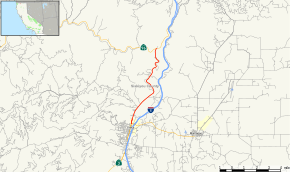
State Route 263 (SR 263) is a state highway in the U.S. state of California in Siskiyou County. It is also part of Business Loop 5 due to being a parallel route of Interstate 5 to the west. Route 263 connects Route 3 near the north city limits of Yreka to Route 96 eight miles (13 km) north. It was once part of U.S. Route 99.
Route description

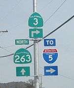
The road begins at a junction with State Route 3 just north of Yreka. The highway then heads upward through Siskiyou County, roughly lying parallel to the Klamath River. The road passes also roughly aligned with nearby Interstate 5 as it passes through hilly terrain. The road ends at State Route 96, which continues northward to meet up with Interstate 5.[2]
Major intersections
Except where prefixed with a letter, postmiles were measured on the road as it was in 1964, based on the alignment of U.S. Route 99 as it existed at that time, and do not necessarily reflect current mileage. R reflects a realignment in the route since then, M indicates a second realignment, L refers an overlap due to a correction or change, and T indicates postmiles classified as temporary (for a full list of prefixes, see the list of postmile definitions).[1] Segments that remain unconstructed or have been relinquished to local control may be omitted. The entire route is in Siskiyou County.
| Location | Postmile [1][3][4] | Destinations [5] | Notes | ||
|---|---|---|---|---|---|
| Yreka | 49.07 | South end of I-5 Bus. overlap; south end of SR 263 | |||
| | 57.20 | North end of I-5 Bus. overlap; north end of SR 263 | |||
1.000 mi = 1.609 km; 1.000 km = 0.621 mi
| |||||
See also
References
- 1 2 3 California Department of Transportation. "State Truck Route List". Sacramento: California Department of Transportation. Archived from the original (XLS file) on June 30, 2015. Retrieved June 30, 2015.
- ↑ Microsoft; Nokia (2011-01-26). "SR 263" (Map). Bing Maps. Microsoft. Retrieved 2011-01-26.
- ↑ California Department of Transportation, Log of Bridges on State Highways, July 2007
- ↑ California Department of Transportation, All Traffic Volumes on CSHS, 2005 and 2006
- ↑ DeLorme California Atlas and Gazetteer: Page 25