Bradstreet Historic District
|
Bradstreet Historic District | |
 | |
  | |
| Location | Hatfield, Massachusetts |
|---|---|
| Coordinates | 42°24′19″N 72°35′26″W / 42.40528°N 72.59056°WCoordinates: 42°24′19″N 72°35′26″W / 42.40528°N 72.59056°W |
| Architect | unknown |
| Architectural style | Greek Revival, Second Empire, Colonial Revival |
| NRHP Reference # | [1] |
| Added to NRHP | July 17, 1997 |
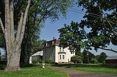
The Bradstreet Historic District encompasses the rural 19th century village of Bradstreet in Hatfield, Massachusetts. It is centered at the junction of Depot Street and Main Street, and includes properties lining those two streets and Old Farm Road. Most of the buildings in the area date to the second half of the 19th century, featuring architectural styles typical of the period, including Queen Anne, Second Empire, Italianate, and Colonial Revival. The village grew on land that was originally granted to colonial governor Simon Bradstreet.[2] The district was listed on the National Register of Historic Places in 1997.[1]
See also
- North Hatfield Historic District
- Hatfield Center Historic District
- Upper Main Street Historic District (Hatfield, Massachusetts)
- National Register of Historic Places listings in Hampshire County, Massachusetts
References
- 1 2 National Park Service (2008-04-15). "National Register Information System". National Register of Historic Places. National Park Service.
- ↑ "MACRIS inventory record for Bradstreet". Commonwealth of Massachusetts. Retrieved 2013-12-19.
| Topics |  | ||||||||||||||||||||||||||||||
|---|---|---|---|---|---|---|---|---|---|---|---|---|---|---|---|---|---|---|---|---|---|---|---|---|---|---|---|---|---|---|---|
| Lists by county | |||||||||||||||||||||||||||||||
| Lists by city |
| ||||||||||||||||||||||||||||||
| Other lists | |||||||||||||||||||||||||||||||
| |||||||||||||||||||||||||||||||
This article is issued from Wikipedia - version of the 11/27/2016. The text is available under the Creative Commons Attribution/Share Alike but additional terms may apply for the media files.