Bishopdale, North Yorkshire
| Bishopdale | |
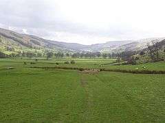 Upper Bishopdale, looking south-west towards Kidstones Pass |
|
 Bishopdale |
|
| OS grid reference | SD956818 |
|---|---|
| District | Richmondshire |
| Shire county | North Yorkshire |
| Region | Yorkshire and the Humber |
| Country | England |
| Sovereign state | United Kingdom |
| Post town | LEYBURN |
| Postcode district | DL8 3 |
| Police | North Yorkshire |
| Fire | North Yorkshire |
| Ambulance | Yorkshire |
| EU Parliament | Yorkshire and the Humber |
| UK Parliament | Richmond (Yorks) (UK Parliament constituency) |
Coordinates: 54°13′55″N 2°04′01″W / 54.232°N 2.067°W
Bishopdale is a dale in the Yorkshire Dales National Park in North Yorkshire, England. The dale is a side dale on the south side of Wensleydale, and extends for some 6 miles (10 km) south west from Aysgarth. Bishopdale is also the name of a civil parish, which includes only the sparsely populated upper reaches of the dale, from the head of the dale as far downstream as Howesyke and Howgill Gill.
There are three villages in the dale, all in its lower part: West Burton, Thoralby and Newbiggin. The Bishopdale Beck flows through the dale to join the River Ure about 1.1 miles (1.8 km) east of Aysgarth. The B6160 road follows the path of the river from its junction with the A684 to the watershed at Kidstones Pass where it continues to Cray and Buckden in Upper Wharfedale. The highest point in the dale is to be found at 640 metres (2,100 ft) about two thirds of the way up Buckden Pike.
The Yorkshire Dales Rivers Trust YDRT has a remit to conserve the ecological condition of Bishopdale Beck from its headwaters to the Humber estuary.
The dale is divided between four civil parishes, Bishopdale, Newbiggin, Thoralby and the northern part of Burton-cum-Walden (which includes the largest village, West Burton), all in the district of Richmondshire. The populations of the four parishes were estimated in 2012 at
Bishopdale 30 Newbiggin 80 Thoralby 160 Burton-cum-Walden 290[1]
The civil parish of Bishopdale was a township of the ancient parish of Aysgarth, and became a separate civil parish in 1866.[2] Population details for Bishopdale can be found under Newbiggin. It now shares a grouped parish council, the Aysgarth & District Parish Council, with Aysgarth, Newbiggin, Thoralby and Thornton Rust.[3]
References
- ↑ "Population Estimates". North Yorkshire County Council. 2012. Retrieved 23 August 2014.
- ↑ Vision of Britain website
- ↑ "Parish and Town Councils". Richmondshire District Council. Retrieved 19 May 2015.
External links
![]() Media related to Bishopdale, North Yorkshire at Wikimedia Commons
Media related to Bishopdale, North Yorkshire at Wikimedia Commons