Thoralby


Coordinates: 54°16′36″N 1°59′59″W / 54.27678°N 1.9997585°W
Thoralby is a village and civil parish in the Richmondshire district of North Yorkshire, England. It lies south of Aysgarth, is within a mile of both Newbiggin and West Burton and is in the Yorkshire Dales National Park. It is 23.5 miles (37.8 km) south west of the County Town of Northallerton.
History
The village is mentioned in the Domesday Book as Turoldesbi. After the Norman invasion the lands were awarded to Count Alan of Brittany, who granted the local manor to Bernwulf, who had held the manor before this.[1] The manor was eventually acquired by the lords of Middleham whose descent it then followed until the Middleham manor holdings were sold piecemeal by commissioners of the Crown in the mid 17th century. The manor of Thoralby was purchased by the Norton family. By the middle of the 18th century it had passed to the Purchas family.[2][3]
On Thoralby Common the remains of lead-mines and quarries are still visible, indicating the industrial past of the area. There has also been a mill here since at least 1298.[2] There used to be both Wesleyan and Primitive Methodist chapels in the village. The Wesleyan Chapel was originally built in 1823 and subsequently rebuilt in 1890. The Primitive Methodist Chapel was erected in 1849. Both are now private properties.[3]
Thoralby was described in the Imperial Gazetteer of England and Wales in 1870–72 as:
- " A township in Aysgarth parish, N. R. Yorkshire; 4½ miles SE of Askrigg. It has a post-office under Bedale. Acres, 2,840. Real property, £2,542. Pop., 271. Houses, 63." [4]
The topynomy of the village name is derived from combining the Old Norse words of Thoraldr, a person's name, and bi for farm, to give the meaning Thoraldr's farm.[5][6]
Governance
The village lies within the Richmond UK Parliament constituency. It also lies within the Upper Dales electoral division of North Yorkshire County Council and the Penhill ward of Richmondshire District Council.[7]
The civil parish shares a grouped parish council, the Aysgarth & District Parish Council, with Aysgarth, Bishopdale, Newbiggin and Thornton Rust.[8]
Geography
The village is located between Littleburn Beck to the south west and Heaning Gill to the north east on the north bank of Bishopdale Beck. The B6160 road runs parallel to the village on the south bank of the beck. It lies south of Aysgarth, is within a mile of both Newbiggin and West Burton
Community and culture
North Yorkshire Council provide 3 bus routes through the village Monday-Saturday.[9] The village hall provides a space for residents to hold functions, sporting events, charity based projects and is the venue to the parish council meetings. It became a registered charity on 22 April 1993, to provide services to the public and charitable events.[10] An annual fete takes place on the first Sunday of August, and includes egg throwing, fell running and various other entertainments. The fete raises funds for the village hall. There is a public house in the village and a general store incorporating the post office. There are no less than 26 Grade II listed buildings in the village, which include the old chapel, post office and public house.[11]
Demography
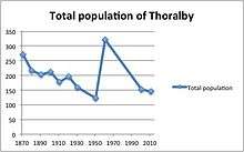
Overall, the population of Thoralby has fluctuated throughout time and this can be seen through the census results. In 1961, Thoralby hit its population peak, with a total residency of 322, which was a significant increase from the 1951 census data, showing just 123 residents; the smallest number on record.[12]
2001 census
The 2001 UK census showed that the population was split 44.7% male to 55.3% female. The religious constituency was made of 84.4% Christian, 1.9% Jewish and the rest stating no religion or not stating at all. The ethnic make-up was 100% White British. There were 95 dwellings.[13]
2011 census
The 2011 UK census showed that the population was split 50% male to 50% female. The religious constituency was made of 69.6% Christian and the rest stating no religion or not stating at all. The ethnic make-up was 99.31% White British and 0.69% White Other . There were 101 dwellings.[14]
Popular culture
Thoralby was featured in the British television series All Creatures Great and Small, in the episode "If Music Be the Food of Love".[15]
References
- ↑ Thoralby in the Domesday Book. Retrieved 6 April 2013.
- 1 2 "History". Retrieved 22 March 2013.
- 1 2 Bulmer's Topography, History and Directory (Private and Commercial) of North Yorkshire 1890. S&N Publishing. 1890. p. 345. ISBN 1-86150-299-0.
- ↑ Wilson, John (1870–72). Imperial Gazetteer of England and Wales (1st ed.). Edinburgh: A.Fullarton and Co. Retrieved 4 February 2013.
- ↑ Watts (2011). Cambridge Dictionary of English Place-names. Cambridge University Press. p. 608. ISBN 978-0521168557.
- ↑ A.D. Mills (1998). Dictionary of English Place-Names. Oxford Paperbacks. p. 457. ISBN 978-0192800749.
- ↑ "Divisions, Wards, Polling Districts and Polling Stations". Richmondshire District Council. Retrieved 19 May 2015.
- ↑ "Parish and Town Councils". Richmondshire District Council. Retrieved 19 May 2015.
- ↑ "Bus Routes serving Thoralby". North Yorkshire Council. Retrieved 22 March 2013.
- ↑ "Thoralby and District village Hall". Open Charities. Retrieved 22 March 2013.
- ↑ "Village listed buildings". Retrieved 6 April 2013.
- ↑ "Thoralby CP/Tn through time". Population Statistics. A Vision of Britain. Retrieved 22 March 2013.
- ↑ "2001 UK Census". Office for National Statistics. 2002. Retrieved 6 April 2013.
- ↑ "2011 UK Census". Office for National Statistics. 2013. Retrieved 25 March 2013.
- ↑ "Old Chapel, Thoralby, N Yorkshire, UK – All Creatures Great & Small, If Music be the Food of Love (1990)" – Waymarking.com
External links
![]() Media related to Thoralby at Wikimedia Commons
Media related to Thoralby at Wikimedia Commons