Binna Burra
| Binna Burra Queensland | |||||||||||||
|---|---|---|---|---|---|---|---|---|---|---|---|---|---|
 Antarctic Beech trees, 3km from Binna Burra Mountain Lodge | |||||||||||||
| Established | 1933 | ||||||||||||
| Postcode(s) | 4211 | ||||||||||||
| Location | 46 km (29 mi) from Southport | ||||||||||||
| LGA(s) | Scenic Rim Region | ||||||||||||
| State electorate(s) | Beaudesert | ||||||||||||
| Federal Division(s) | Wright | ||||||||||||
| |||||||||||||


Binna Burra is a parcel of private land and mountain lodge surrounded by Lamington National Park in Queensland, Australia. It is also the name of a locality in the same area within the Scenic Rim Region.[1] The lodge lies in the north-eastern corner of the Lamington Plateau in the McPherson Range, 75 km south of Brisbane. It is marketed as an ecolodge and was one of the first nature based resorts to be established in Australia.[2] In 2000, the resort was the first commercial accommodation provider to be awarded Green Globe Certification in Australia.[2] The lodge and other aspects of the built environment at Binna Burra are listed on the Queensland Heritage Register as the Binna Burra Cultural Landscape.[3]
Binna Burra means "where the Antarctic Beech trees grow" in a local Aboriginal language.[4]
History
The mountain lodge was founded in 1933.[5] From the outset the company aimed to make ecotourism and environmental protection a significant objective under the guidance of one of its founders Romeo Lahey.[5] Binna Burra remained apart from the nearby national park as the properties around were bought by the Queensland Government on an irregular basis, to extend the size of the park. In 2012, facilities were expanded with the construction of 20 modern new apartments to add to the log cabins already accommodating visitors.[2]
Forests
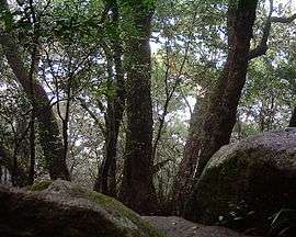
The forests in the area are part of the World Heritage site, Gondwana Rainforests of Australia (formerly Central Eastern Rainforest Reserves). The name, Binna Burra, is an Aboriginal word meaning "where the beech tree grows," referring to a stand of Antarctic Beech (Nothofagus moorei) growing in the nearby rainforest, as shown in the adjacent image.
The vegetation ranges from subtropical and temperate rainforest to dry eucalypt and open heath. Binna Burra features a visitors centre, cafe, a guesthouse, campsites, safari tents, powered sites, picnic grounds, an "Environmental Education Centre", and conference facilities. The clearing at Binna Burra affords extensive views to the north.
Access
Access to Binna Burra is from Beechmont, via a mountainous road not suitable for large caravans. In 2001, 108,551 vehicles were recorded by counters as entering Binna Burra.[6] More recently this figure has increased to around 250,000 visitors per year.[2]
Bushwalking
Extending away from the clearing a number of short and long walks, many of which were designed and built by Romeo Lahey during the Great Depression.[7] All of Lahey's track's have a gradient not greater than 10%. Lahey had noticed that the local dairy cows never seemed out of breath.[7] After surveying the animals paths he concluded a ratio of 1:10 for a gradient was best. These graded walking tracks lead to the upper Coomera River and numerous smaller creeks, Coomera Gorge, Coomera Falls amongst many other waterfalls. To the east is the Ship Stern Range and Dave's Creek circuit and the all-day hike along the Coomera Track.
In popular culture
Binna Burra was featured on the third season of The Mole. An assignment involved the contestants having to travel up to Binna Burra, whilst on the way answering questions that would help them in succeeding in the assignment.
See also
References
- ↑ "Binna Burra (entry 45113)". Queensland Place Names. Queensland Government. Retrieved 2 November 2016.
- 1 2 3 4 Prideaux, Bruce (2014). Rainforest Tourism, Conservation and Management: Challenges for Sustainable Development. Routledge. pp. 109–110. ISBN 1136201092. Retrieved 15 October 2015.
- ↑ "Binna Burra Cultural Landscape (entry 601899)". Queensland Heritage Register. Queensland Heritage Council. Retrieved 1 August 2014.
- ↑ Hundloe, Tor (2015). "The Gold Coast: a snapshot". In Hundloe, Tor; McDougall, Bridgette; Page, Craig. The Gold Coast Transformed: From Wilderness to Urban Ecosystem. Csiro Publishing. p. 29. ISBN 1486303307. Retrieved 15 October 2015.
- 1 2 Lockwood, Michael; Graeme L. Worboys; Ashish Kothari (2006). Managing protected areas: a global guide. Earthscan. p. 501. ISBN 1844073033. Retrieved 15 April 2013.
- ↑ Tisdell, C. Clement Allan; Clevo Wilson (2012). Nature-Based Tourism and Conservation: New Economic Insights and Case Studies. Edward Elgar Publishing. pp. 178–179. ISBN 1781005168. Retrieved 15 April 2013.
- 1 2 Lackner, Thomas. (1989) Discovering Binna Burra on Foot. Envirobook ISBN 0-85881-088-3
External links
| Wikimedia Commons has media related to Binna Burra. |
Coordinates: 28°08′32″S 153°06′55″E / 28.14222°S 153.11528°E