Aratula
| Aratula Queensland | |
|---|---|
 St Stephen's Anglican church | |
 Aratula | |
| Coordinates | 27°58′53″S 152°32′55″E / 27.98139°S 152.54861°ECoordinates: 27°58′53″S 152°32′55″E / 27.98139°S 152.54861°E |
| Population | 505 (2011 census)[1] |
| Postcode(s) | 4309 |
| Location |
|
| LGA(s) | Scenic Rim Region |
| State electorate(s) | Beaudesert |
| Federal Division(s) | Blair |
Aratula is a small town and locality in Scenic Rim Region, Queensland, Australia.[2][3] At the 2011 census, Aratula had a population of 505.[1]
Geography
Aratula is approximately 60 kilometres (40 mi) southwest of Ipswich, just east of Cunninghams Gap. Warrill Creek passes very close to the town.
History
The area was originally known as Carter's Gate, but the name was changed to reflect the railway station name of Aratula.[2][4]
Carter's Gate Provisional School opened on 29 May 1911. It became a State School on 9 January 1913. The name was changed in August 1913 to Aratula State School.[5][6][7]
Aratula Post Office opened around 1925 (a receiving office had been open since 1912[4]) and closed in 1987.[8]
Heritage listings
Aratula has the following heritage sites:
- 25 Elizabeth Street: St Stephen’s Anglican Church[9]
Attractions
Local attractions include nearby Moogerah Peaks National Park, Main Range National Park, Lake Moogerah and ballooning.
Amenities
Aratula is a common rest-stop for travellers coming eastward across the Great Dividing Range. There is a caravan park and a hotel just off the highway.
Churches


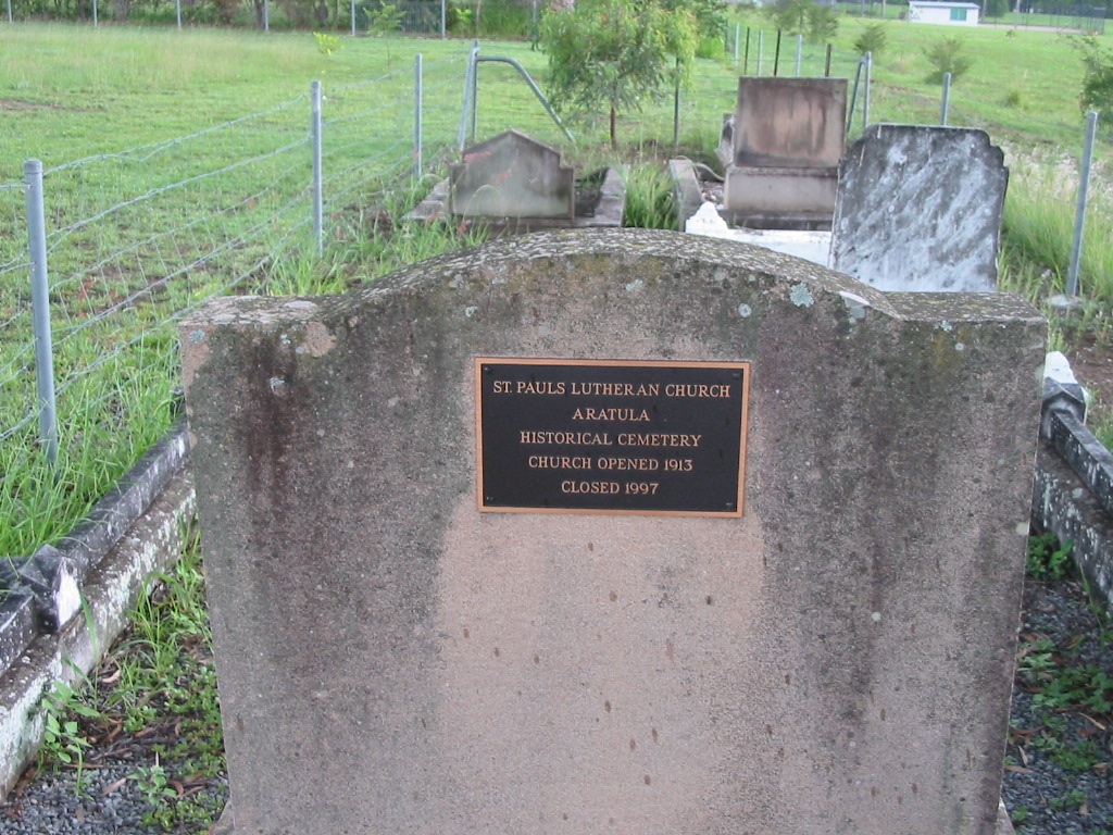
St Pauls Lutheran Church opened in 1913 and closed in 1997,[10] but the church building still stands at 57 Elizabeth Street (27°58′51″S 152°32′34″E / 27.9807°S 152.5427°E). There is a Lutheran cemetery behind the church; the first burial was Hermann Gustav Muller in March 1916.[11]
St Stephens Anglican Church opened in 1954 and is at 25 Elizabeth Street (27°58′53″S 152°32′46″E / 27.9813°S 152.5462°E).[12]
See also
References
- 1 2 Australian Bureau of Statistics (31 October 2012). "Aratula (State Suburb)". 2011 Census QuickStats. Retrieved 12 July 2013.
- 1 2 "Aratula (town) (entry 40970)". Queensland Place Names. Queensland Government. Retrieved 10 May 2014.
- ↑ "Aratula (locality) (entry 45107)". Queensland Place Names. Queensland Government. Retrieved 10 May 2014.
- 1 2 "New Name for Receiving-Office". Queensland Times. 14 Feb 1912. Retrieved 12 Aug 2014.
- ↑ "Opening and closing dates of Queensland Schools". Queensland Government. Retrieved 10 May 2014.
- ↑ "Agency ID4792, Aratula State School". Queensland State Archives. Retrieved 12 May 2014.
- ↑ "Our school". Aratula State School. Archived from the original on 11 May 2014. Retrieved 12 May 2014.
- ↑ Premier Postal History. "Post Office List". Premier Postal Auctions. Retrieved 10 May 2014.
- ↑ "Local Heritage Register" (PDF). Scenic Rim Regional Council. Retrieved 9 February 2015.
- ↑ "St Pauls Lutheran Church Aratula Historical Cemetery". Retrieved 11 May 2014.
- ↑ "Aratula News.". Queensland Times (Ipswich) (Qld. : 1909 - 1954). Ipswich) (Qld.: National Library of Australia. 8 April 1916. p. 2 Edition: DAILY. Retrieved 12 May 2014.
- ↑ "St. Stephen's Anglican Church, Aratula". Anglican Parish of Boonah-Harrisville. Archived from the original on 11 May 2014. Retrieved 12 May 2014.
External links
![]() Media related to Aratula, Queensland at Wikimedia Commons
Media related to Aratula, Queensland at Wikimedia Commons