Beli Manastir
| Beli Manastir | |
|---|---|
| Town | |
| Town of Beli Manastir Grad Beli Manastir | |
|
Beli Manastir Sports Hall | |
 Beli Manastir Location of Beli Manastir in Croatia | |
| Coordinates: HR 45°46′N 18°36′E / 45.767°N 18.600°ECoordinates: HR 45°46′N 18°36′E / 45.767°N 18.600°E | |
| Country |
|
| County | Osijek-Baranja |
| Government | |
| • Mayor | Ivan Doboš (SDP) |
| Area | |
| • Town | 55 km2 (21 sq mi) |
| Elevation | 100 m (300 ft) |
| Population (2011)[1] | |
| • Town | 10,068 |
| • Urban | 8,049 |
| Time zone | CET (UTC+1) |
| • Summer (DST) | CEST (UTC+2) |
| Postal code | 31300 Beli Manastir |
| Area code(s) | (+385) 31 |
-Nastavno-sportska-dvorana.jpg)
Beli Manastir is a town and municipality in eastern Croatia. It is the principal town of the Croatian part of Baranja, located in the Osijek-Baranja County.
Name
The name means "white monastery" in Serbian language. This name was imposed in 1923 during the Serb-dominated Kingdom of Serbs, Croats and Slovenes, and before this it was known as Monoštor in Croatian. It is also known as Pélmonostor in Hungarian, Manoster in German and Бели Манастир in Serbian Cyrillic.
Other names formerly used for the town were: Pél, Bell, and Monostor. All names are connected with monasteries that existed in history at this location. The first monastery was built in the 9th century during the rule of Slavic duke Kocelj but was later razed, and all that remained of it was pil (obelisk in English), hence the later Hungarian name Pél, which was a version of the Slavic word.
History
In the 9th century, this area was part of the Slavic Principality of Lower Pannonia and Slavic monastery was situated here. Monastery was founded during the visit of Cyril and Methodius, who spread Christianity among Slavs. After Methodius died, his students were expelled and the monastery was razed.
After the arrival of the Hungarians in the 10th century, this area was included into the newly founded Hungarian state and the settlement was built at this locality. The town was first mentioned in 1212 under name Pél. During Hungarian administration, another monastery was built here (in the 13th century), but it was destroyed by the Mongols in 1241. It was later rebuilt, but was again destroyed during the Ottoman conquest in the 16th century. Between 11th and 16th century, the area administratively belonged to the Baranya county.
In the 16th–17th century, area was part of the Ottoman Empire and administratively belonged to the Sanjak of Mohaç. Since the end of the 17th century, area was part of the Habsburg Monarchy and administratively belonged to the Baranya county, which was part of the Habsburg Kingdom of Hungary.
Since 1918, the town was part of the Kingdom of Serbs, Croats and Slovenes (later renamed to Yugoslavia). From 1918 to 1922, it was part of the Novi Sad county, from 1922 to 1929 part of the Bačka Oblast, and from 1929 to 1941 part of the Danube Banovina. From 1941 to 1944, it was occupied by Hungary and was administratively included into Baranya county. It was returned to Yugoslav control in 1944 and was administratively part of Vojvodina until 1945, when it was transferred to the People's Republic of Croatia.
During the Croatian War of Independence (1991–1995), Beli Manastir was occupied by Serbian paramilitaries and incorporated along with some other towns into the Republic of Serbian Krajina. It was returned to Croatian control after the war, following the short period of UN administration (1996–1998).
The town has had a diverse ethnic composition since its earliest times. The population of the town through the history included Croats, Germans, Hungarians, Serbs and Romani . Some Serbs to left the city after the UNTAES ended.
Town of Beli Manastir
Geography
The municipality of Beli Manastir is composed of 4 settlements:[1]
- Beli Manastir, population 8,049
- Branjin Vrh, population 993
- Šećerana, population 540
- Šumarina, population 486
Demographics
1910
According to the 1910 census, the town had 2,447 inhabitants, of which:[2]
- Germans – 1,496 (61.1%)
- Serbs – 478 (19.5%)
- Hungarians – 443 (18.1%)
- Croats – 6 (0.24%)
- others – 24 (0.98%)
1929
In 1929 the population was made of:
- Hungarians – 33.8%
- Germans – 32.6%
- Croats – 18.8%
- Serbs – 12%
1981
53,409 total
- Croats – 19,136 (35.83%)
- Serbs – 12,857 (24.07%)
- Hungarians – 9,920 (18.57%)
- Yugoslavs – 8,850 (16.57%)
- Slovenes – 353 (0.66%)
- Montenegrins – 276 (0.52%)
- Romani – 262 (0.49%)
- Muslims – 82 (0.15%)
- Albanians – 56 (0.11%)
- Macedonians – 45 (0.08%)
2001
The town had a population of 8,671, while total municipality population was 10,986. Ethnic composition of Beli Manastir municipality by 2001 census was:[3]
- Croats = 6,085 (55.39%)
- Serbs = 2,920 (26.58%)
- Hungarians = 933 (8.49%)
- Romani = 153 (1.39%)
- Germans = 122 (1.11%)
Buildings and structures
In 1966, a broadcasting mast standing 202 metres high was erected.[4]
Economy
Beli Manastir is home to the STARCO Beli steel wheel factory.
Beli Manastir (settlement)
Parts of settlement (hamlets)
Beli Manastir, Beli Manastir-Planina, Haljevo and Palača. Till 1991. part of settlement was also Sudaraž which is now independent settlement.
Population
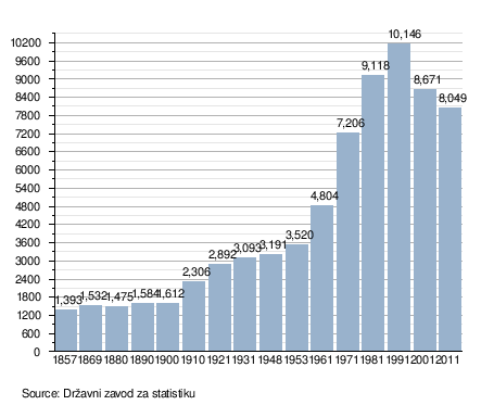
Population data graph 1857.-2011.[5]
Ethnic composition, 1991. census
| Beli Manastir |
|---|
| 1991 |
| total: 10,146 Romanians 8 (0.07%) Ruthenians 2 (0.01%) Greeks 1 (0.00%) Italians 1 (0.00%) others 11 (0.10%) ethnically undecl. 369 (3.63%) regionaly declared 11 (0.10%) unknown 56 (0.55%)
|

Austria-Hungary 1910. census
| Beli Manastir | |
|---|---|
| Population by ethnicity | Population by religion |
| total: 2,447 others 24 (0.98%)
|
total: 2,447 |
- In 1910. census together with settlement Sudaraž.
See also
References
- 1 2 "Population by Age and Sex, by Settlements, 2011 Census: Beli Manastir". Census of Population, Households and Dwellings 2011. Zagreb: Croatian Bureau of Statistics. December 2012.
- ↑ Atlas and Gazetteer of Historic Hungary 1914, Talma Kiadó
- ↑ http://www.dzs.hr/Hrv/censuses/Census2001/Popis/H01_02_02/H01_02_02_zup14.html
- ↑ http://en.structurae.de/structures/data/index.cfm?id=s0006009
- ↑ Naselja i stanovništvo Republike Hrvatske 1857.-2001., www.dzs.hr Archived 5 May 2012 at the Wayback Machine.
Literature
- Book: "Narodnosni i vjerski sastav stanovništva Hrvatske, 1880–1991: po naseljima, autor: Jakov Gelo, izdavač: Državni zavod za statistiku Republike Hrvatske, 1998., ISBN 953-6667-07-X, ISBN 978-953-6667-07-9;
External links
| Wikimedia Commons has media related to Beli Manastir. |