Ploče
| Ploče | |
|---|---|
| Town | |
|
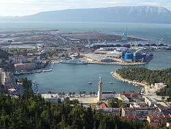
Ploče harbor | |
 Ploče The location of Ploče within Croatia | |
| Coordinates: 43°03′24″N 17°25′54″E / 43.05667°N 17.43167°E | |
| Country |
|
| County |
|
| Government | |
| • Mayor | Krešimir Vejić (HDZ) |
| Elevation | 0 m (0 ft) |
| Population (2011)[1] | |
| • Town | 10,135 |
| • Urban | 6,013 |
| Time zone | CET (UTC+1) |
| • Summer (DST) | CEST (UTC+2) |
| Postal code | 20 340 |
| Area code(s) | 020 |
| Vehicle registration | DU |
| Website | ploce.hr |
Ploče (pronounced [plɔ̂tʃɛ]; Italian: Porto Tolero) is a town and a notable seaport in the Dubrovnik-Neretva County of Croatia.
Geography
Ploče is located on the Adriatic coast in Dalmatia just north of the Neretva Delta and is as such the natural seaside endpoint of most north-south routes through the central Dinaric Alps. This makes it the primary seaport used by Bosnia and Herzegovina and the endpoint of the Pan-European corridor 5C.
Čeveljuša is a toponym in Ploče, located to the east of the town, on the intersection of the D8 highway and the D425.[2]
History
Ploče was named Kardeljevo after the Yugoslav politician Edvard Kardelj between 1950 and 1954 and again between 1980 and 1990. Some locals call their city Ploča.
Population
The total population of Ploče is 10,135 (2011), in the following settlements:[1]
In the 2011 census, the majority of its citizens were Croats at 95.93%.[3]
Port

The Port of Ploče was first mentioned on 6 November 1387, but the building of a larger port was done in recent modern times. Work on the present day harbour first began in 1939 [4] but was destroyed during World War II. It was rebuilt in 1945 and the village of Ploče grew up to 480 inhabitants in 1948. After the Adriatic road and Neretva railway lines were built to the port in the mid-1960s, the town experienced a steady growth.
Bosnia and Croatia are currently in negotiations as regards the establishment of a "privileged economic zone" for Bosnian businesses within the Ploče port facilities, though this development is hindered by the opposition of local government, and Croatian people to the concept of a partial loss of sovereignty over the port. The Bosnian government would like a concession, with sovereignty features, for at least 99 years, whereas the Croatian government only wishes to offer commercial passage through Croatian territory for Bosnian and Herzegovinian goods. This topic was a subject of lengthy negotiations; easier passage for Croatian citizens through the narrow strip of Bosnia and Herzegovina territory (that divides Croatia's land territory) near Neum, in exchange for privileges for Bosnia and Herzegovina in Ploče. The proposed building of a bridge through Croatian territory (the Pelješac Bridge), bypassing Neum and Bosnian territory completely may solve this problem for Croatia, although this proposal is currently being strongly resisted by the Bosnian government.[5]
International relations
Twin towns – Sister cities
Ploče is twinned with:
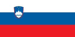 Ljubljana, Slovenia[6]
 Rodi Garganico
References
- 1 2 "Population by Age and Sex, by Settlements, 2011 Census: Ploče". Census of Population, Households and Dwellings 2011. Zagreb: Croatian Bureau of Statistics. December 2012.
- ↑ "Čvor Čeveljuša: policija uvodi rigorozne mjere". Slobodna Dalmacija (in Croatian). 2008-04-29. Retrieved 2010-09-26.
- ↑ "Population by Ethnicity, by Towns/Municipalities, 2011 Census: County of Dubrovnik-Neretva". Census of Population, Households and Dwellings 2011. Zagreb: Croatian Bureau of Statistics. December 2012.
- ↑ Port Authority Ploce-History
- ↑ "Bosnia vexed by Croatian bridge". BBC. 2007-10-25. Retrieved 2010-05-14.
- ↑ "Medmestno in mednarodno sodelovanje". Mestna občina Ljubljana (Ljubljana City) (in Slovenian). Retrieved 2013-07-27.
External links
| Wikimedia Commons has media related to Ploče. |
- Official website (Croatian)
Subdivisions of Dubrovnik-Neretva County | ||
|---|---|---|
| Cities and towns |  | |
| Municipalities | ||
| Countries |  | ||||||
|---|---|---|---|---|---|---|---|
| Places | |||||||
| Tributaries |
| ||||||
| Lakes |
| ||||||
| Related articles | |||||||
Coordinates: 43°03′N 17°26′E / 43.050°N 17.433°E