Carnewas and Bedruthan Steps

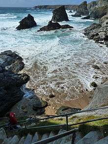
Carnewas & Bedruthan Steps (Cornish: Karn Havos, meaning rock-pile of summer dwelling and Cornish: Bos Rudhen, meaning Red-one's dwelling) is a stretch of coastline located on the north Cornish coast between Padstow and Newquay, in Cornwall, England, United Kingdom.[1] It is within the parish of St Eval and is part owned by the National Trust. The Trust maintains a shop and cafe and the cliff–top view of rocks stretching into the distance along Bedruthan beach makes the area a popular attraction for tourists and painters. The property affords walks along the coast path and the steep steps at Bedruthan allow access to a series of rocky beaches at low tide (not owned by the Trust). Signs at the top of the steps down to the beaches warn visitors not to risk swimming in these waters due to heavy rips, fast tides and submerged rocks.
History
There have been people in the area since at least the Bronze Age with six barrows nearby to the north, and overlooking Bedruthan Steps is Redcliff Castle, which dates back to at least the Iron Age. Redcliff Castle has three ramparts divided by two ditches, part of which have been quarried to improve the defences. Much of the internal parts of the castle have been eroded by the sea. There is a second castle within a mile to the north at Park Head and two miles to the south at Griffin's Point, a third. Cliff Castles or Promontory forts are defensive structures which are thought by archaeologists to be permanently occupied.[2] In 2009 a menhir or longstone was discovered in a boundary hedge close to the coastal footpath. The stone lies on its side and is 9 feet (2.7 m) long.[3]
There is evidence of mining with shafts on the cliffs nearby at Trenance Point, and adits above the beach at Carnewas. The National Trust shop was originally the count house (office) of Carnewas Mine and the cafe was one of the mine buildings. Between 1871 and 1874, 940 tons of brown haematite were produced and it is thought that the ladders and steps to the beach were needed to reach the mine workings. The name Bedruthan Steps is said to be taken from a mythological giant called 'Bedruthan' who used the rocks (stacks) on the beach as stepping stones, and seems to be a late nineteenth century invention for Victorian tourists. The first written record of the name is from the West Briton newspaper in February 1847 and is likely to refer to one of two cliff staircases used by miners to get to the mine workings and now refers to the whole beach.[2]
Each of the stacks has a name and from north to south they are Queen Bess, Samaritan Island, Redcove Island, Pendarves Island and Carnewas Island. Samaritan Island is named after a ship the Good Samaritan which was wrecked there in October 1846 with the loss of nine lives.
Environment
"Bedruthan Steps and Park Head" is an 80.8 hectares (200 acres) Site of Special Scientific Interest, designated for its geological and biological interest in 1951. The site was subject to a revision in 1973 and re–notified in 1986. It is noted for its slates and fossils from the Middle Devonian period, various mosses and beetles.[4] Bedruthan Steps is also a Geological Conservation Review (GCR) site because it is a ″source of rare fish specimens″ which were first reported in 1848 by W Pengelly.[5]
- Geology
The underlying rock from Bedruthan Steps to Trevose Head is Middle Devonian slates (386–377 Ma) with Staddon Grits to the south towards Trenance Point. The thickness of the slates have been estimated at over 2,000 metres (6,600 ft). Marine erosion by the sea carrying sand and pebbles have worn away the weaker, softer rocks to leave the stacks we see today. Fossils of fish, corals, trilobites, etc. have been found in the Eifelian slates on Samaritan and Pendarves Islands.[6] There are few fossils useful for dating here but one (although considered to be problematical) Pteroconus mirus dates the formations to the Eifelian.[7] At the end of the headland of Park Head (grid reference SW840708) is a sub volcanic rock, Diabase.
- Dark Sky Discovery Site
In 2014 the area was granted "Dark Sky" status by the Science & Technology Facilities Council (STFC). Dark Sky Discovery Sites must be free from light pollution and have good views of stars and the Milky Way, as well as being accessible to the public.[8]
References
- ↑ Ordnance Survey: Landranger map sheet 200 Newquay & Bodmin ISBN 978-0-319-22938-5
- 1 2 Le Messurier, Brian (1998). Trevose to Watergate Bay including Bedruthan Steps (not NT). National Trust. p. 8.
- ↑ Harper, Sheila. "Carnewas Longstone – Standing Stone (Menhir)". The Megalithic Portal. Retrieved 21 May 2012.
- ↑ "Bedruthan Steps and Park Head" (PDF). Natural England. 1986. Archived from the original (PDF) on 24 October 2012. Retrieved 25 October 2011.
- ↑ "Geological Conservation Review. Bedruthan Steps" (PDF). JNCC. Retrieved 24 December 2012.
- ↑ Bristow, Colin M (1996). Cornwall's Geology and Scenery. An Introduction. St Austell: Cornish Hillside Publications. ISBN 1 900147 00 9.
- ↑ Beese, A P (1982). Power, G M, ed. "The argillite facies of the Middle Devonian succession in north Cornwall" (PDF). Proceedings of the Ussher Society. Crediton: Ussher Society. 5 (3). ISSN 0566-3954. Retrieved 15 December 2012.
- ↑ "Cornwall gains two stargazing Dark Sky sites". BBC. Retrieved 10 January 2014.
External links
Cornwall Portal | |
| Unitary authorities | |
| Major settlements |
|
| Rivers | |
| Topics | |
Coordinates: 50°28′52″N 5°01′55″W / 50.481°N 5.032°W