Bealeton, Virginia
| Bealeton, Virginia | |
|---|---|
| Census-designated place | |
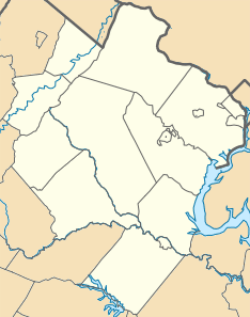 Bealeton  Bealeton  Bealeton Location within Fauquier county | |
| Coordinates: 38°34′58″N 77°46′4″W / 38.58278°N 77.76778°WCoordinates: 38°34′58″N 77°46′4″W / 38.58278°N 77.76778°W | |
| Country | United States |
| State | Virginia |
| County | Fauquier |
| Area | |
| • Total | 5.49 sq mi (14.21 km2) |
| • Land | 5.47 sq mi (14.18 km2) |
| • Water | 0.01 sq mi (0.03 km2) |
| Elevation | 324 ft (99 m) |
| Population (2010) | |
| • Total | 4,435 |
| • Density | 810/sq mi (312.8/km2) |
| Time zone | Eastern (EST) (UTC-5) |
| • Summer (DST) | EDT (UTC-4) |
| ZIP code | 22712 |
| FIPS code | 51-05336 |
| GNIS feature ID | 1499100 |
Bealeton is an unincorporated community and census-designated place (CDP) in Fauquier County, Virginia, United States, at the intersection of State Route 28 and U.S. Route 17. The population as of the 2010 census was 4,435.[1]
Public schools in Bealeton include Grace Miller Elementary, Cedar Lee Middle, and Liberty High School. Bealeton is home to its own post office, with ZIP code 22712. On May 15, 2006, ground was broken on a 5,960-square-foot (554 m2), $2.3 million post office to replace the old one.[2] It was completed in 2007.
Geography
Bealeton is located in southwestern Fauquier County. U.S. Route 17 leads north 10 miles (16 km) to Warrenton, the county seat, and southeast 27 miles (43 km) to Fredericksburg. VA 28 leads northeast 20 miles (32 km) to Manassas and southwest 2.5 miles (4.0 km) to U.S. Routes 29 and 15, which lead an additional 13 miles (21 km) to Culpeper.
According to the U.S. Census Bureau, the Bealeton CDP has a total area of 5.5 square miles (14.2 km2), of which 0.01 square miles (0.03 km2), or 0.23%, is water.[1] The area drains south via Marsh Run to the Rappahannock River.
History
Bealeton was originally a stop on the former Orange and Alexandria Railroad (absorbed ultimately into the Southern Railway in 1894, now Norfolk Southern), and the old railroad station building can be seen in the Bealeton Station development in front of the new Bealeton Library building. The building was previously located on County Road 805, Bealeton Road, which runs parallel and near the railway. The area was a major traveling point during the Civil War and saw many skirmishes related to nearby engagements.
Despite the presence of Confederate troops during the early years of the war, Union troops succeeded in pushing the Confederate line south of the Rappahannock River and eventually into Fredericksburg. This move led to the control of the Orange and Alexandria Railroad, thus allowing the Union army to transport supplies deep into southern Virginia.
Bealeton lost importance with the decline of railroad travel and became a bedroom community of Warrenton and northern Virginia primarily. This was aided by the comprehensive plan that made authorized water and sewer availability in 1967. Bealeton retains many large farms and provides a unique blend of agriculture, commercial, and residential development.
Local attractions
Since 1970, Bealeton has been home to one of the last barnstorming air shows in America, simply called the "Flying Circus".[3] Open every Sunday, May through October, activities include All-American barnstorming, wing walking, parachuting, aerobatic performances and open-cockpit biplane rides.
References
- 1 2 "Geographic Identifiers: 2010 Demographic Profile Data (G001): Bealeton CDP, Virginia". U.S. Census Bureau, American Factfinder. Retrieved October 18, 2016.
- ↑ New Post Office Breaks Ground
- ↑ The Bealeton Flying Circus
External links
- Fauquier County Public Library, with a Bealeton branch
- Bealeton Station Depot at Virginia.org
Municipalities and communities of Fauquier County, Virginia, United States | ||
|---|---|---|
| Towns | 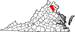 | |
| CDPs | ||
| Unincorporated communities | ||
| Footnotes | ‡This populated place also has portions in an adjacent county or counties | |