Belle Meade, Virginia
| Belle Meade, Virginia | |
|---|---|
| Unincorporated community | |
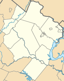 Belle Meade  Belle Meade  Belle Meade Location within Warren county | |
| Coordinates: 38°39′27″N 77°43′01″W / 38.65750°N 77.71694°WCoordinates: 38°39′27″N 77°43′01″W / 38.65750°N 77.71694°W | |
| Country | United States |
| State | Virginia |
| County | Warren |
| Time zone | Eastern (EST) (UTC-5) |
| • Summer (DST) | EDT (UTC-4) |
| ZIP codes | 22643 |
Belle Meade is a small, unincorporated community in Fauquier County, Virginia, situated on State Route 55, and bypassed by Interstate 66. The hamlet is east of the Warren County line in the vicinity of Distillery Road. The Norfolk Southern Railway B-line runs through it, as well as being near the Appalachian Trail and the G Richard Thompson Wildlife Management Area.
The term 'Belle Meade' is losing local use.
Belle Meade is also the name of a small suburban community in Roanoke County, Southwest Virginia, with the zip code of 24018.
Municipalities and communities of Fauquier County, Virginia, United States | ||
|---|---|---|
| Towns | 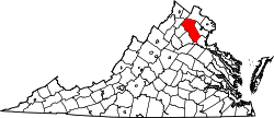 | |
| CDPs | ||
| Unincorporated communities | ||
| Footnotes | ‡This populated place also has portions in an adjacent county or counties | |
This article is issued from Wikipedia - version of the 10/18/2016. The text is available under the Creative Commons Attribution/Share Alike but additional terms may apply for the media files.