Great Barford
| Great Barford | |
 Post Office and High Street |
|
 Great Barford |
|
| Population | 1,930 [1] 2,003 (2011 Census)[2] |
|---|---|
| OS grid reference | TL126545 |
| Unitary authority | Bedford |
| Ceremonial county | Bedfordshire |
| Region | East |
| Country | England |
| Sovereign state | United Kingdom |
| Post town | BEDFORD |
| Postcode district | MK44 |
| Dialling code | 01234 |
| Police | Bedfordshire |
| Fire | Bedfordshire and Luton |
| Ambulance | East of England |
| EU Parliament | East of England |
| UK Parliament | North East Bedfordshire |
|
|
Coordinates: 52°09′29″N 0°21′11″W / 52.158°N 0.353°W
Great Barford is a village and civil parish in Bedfordshire, England, a few miles north-east of Bedford. It lies on the River Great Ouse at grid reference TL129523. It is twinned with Wöllstein, Germany. The village is bypassed by the busy A421 road on the way between Bedford and St Neots in Cambridgeshire, the bypass opening on 24 August 2006.
The village is known for its All Saints Church, with a 15th-century tower, and its similarly ancient bridge . The surroundings and historic buildings make it a favoured destination for canoeing, angling and picnics. Nearby places include Renhold and Blunham.
History
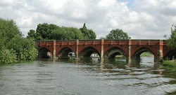
Great Barford was mentioned in the Domesday Book as an important site, probably as a means of crossing the river that skirts the village. Although the area of the original ford was dug up in 1973, the bridge has existed since at least the 15th century.
The village itself is large and scattered but the majority of the houses are in the south-east of the parish. Throughout the village there are a large variety of houses some dating to the 17th century.
The village was once home to Great Barford Castle , a Norman motte and bailey castle, which stood to the north of the village, but a priory has since been built on its location.
A very early reference to Barford may perhaps be found in a charter by which Offa, King of Mercia, in 792 confirmed various lands to the monastery of St. Albans. The charter purports to have been granted in the place which is called 'Æt beranforda.' The text of the charter is certainly spurious, but the witnesses and dating clause may well have been taken from a genuine instrument. Even so, however, the identification with the present Barford cannot be considered certain.
Education
As part of Bedfordshire, Great Barford shares a three-tier schooling system and is home to a lower (Great Barford Lower School) and middle school (Alban Church of England Academy).
For upper school education, students of Great Barford are in the catchment area of Sandy Upper School in the nearby market town of Sandy.
References
- ↑ Bedfordshire County Council, Population Estimates and Forecasts, estimate for 2007.
- ↑ "Civil Parish population 2011". National Statistics. Office for National Statistics. Retrieved 8 November 2016.
External links
| Wikimedia Commons has media related to Great Barford. |