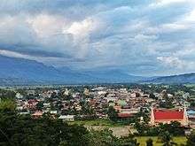
Bambang, Nueva Vizcaya
| Bambang | ||
|---|---|---|
 | ||
| ||
 Map of Nueva Vizcaya showing the location of Bambang | ||
.svg.png) Bambang Location within the Philippines | ||
| Coordinates: 16°23′N 121°07′E / 16.383°N 121.117°ECoordinates: 16°23′N 121°07′E / 16.383°N 121.117°E | ||
| Country | Philippines | |
| Region | Cagayan Valley (Region II) | |
| Province | Nueva Vizcaya | |
| District | Lone district | |
| Barangays | 25 | |
| Government[1] | ||
| • Mayor | Flaviano D. Balgos Jr. | |
| Area[2] | ||
| • Total | 345.00 km2 (133.21 sq mi) | |
| Population (2010)[3] | ||
| • Total | 47,657 | |
| • Density | 140/km2 (360/sq mi) | |
| Time zone | PST (UTC+8) | |
| ZIP code | 3702 | |
| Dialing code | 78 | |
| Income class | 1st class | |

Bambang is a first class municipality in the province of Nueva Vizcaya, Philippines. According to the 2010 census, it had a population of 47,657 people.[3] The municipality is known for its salt springs at the Salinas Natural Monument.
History

Bambang has its beginning in the early period of Spanish colonization. The name "Bambang" is an Isinay word meaning "to dig".
The first mission that dared to penetrate the dangerous wilderness and insect-infested jungles of what is southern Nueva Vizcaya today was by the Dominican Order in 1607. However, it was only two years later (1609) when a Dominican missionary come from Pangasinan. Father Tomas Gutierez arrived to establish the first missionary settlement. This settlement was subsequently called Ytuy which today actually comprises the towns of Aritao, Dupax, Bambang and a part of the Igorot tribal lands to the west (now Kayapa). Originally these places were inhabited by the Igorot and Panuypuyes (Aritao), the Ilongots (Dupax and Bambang) and the lgorot in the area west from the present native population of Dupax, Aritao, and Bambang came about by the inter-marriages of the tribes mentioned above.
Recent development and progress
In 2012, Bambang became open to big dealers and businessmen as part of its progress. Now the town has its own newly opened fast food chains and other marketing establishments.[4]
Administration
As per National Statistics Office of Philippines (NSO), Nueva Vizcaya province is part of Region-II (Cagayan Valley), Province Code for Nueva Vizcaya is 50, Municipality Code for Bambang Municipality within Nueva Vizcaya province is 4.
Province of Nueva Vizcaya is administered or governed by a Governor. Bambang Municipality is administered or governed by a Mayor. Each Barangay is administered or governed by a Punong Barangay (Barangay Captain in English).
Barangays
Bambang is politically subdivided into 25 barangays.[2]
- Abian
- Abinganan
- Aliaga
- Almaguer North
- Almaguer South
- Banggot (Urban)
- Barat
- Buag (Urban)
- Calaocan (Urban)
- Dullao
- Homestead (Urban)
- Indiana
- Mabuslo
- Macate
- Manamtam
- Mauan
- Salinas
- San Antonio North
- San Antonio South
- San Fernando
- San Leonardo
- Santo Domingo (Tabangan)
- Pallas
- Magsaysay Hill (Urban)
- Santo Domingo West
Demographics
| Population census of Bambang | ||
|---|---|---|
| Year | Pop. | ±% p.a. |
| 1990 | 33,663 | — |
| 1995 | 36,975 | +1.77% |
| 2000 | 41,393 | +2.45% |
| 2007 | 45,440 | +1.29% |
| 2010 | 47,657 | +1.75% |
| Source: National Statistics Office[3] | ||
Transportation
Among the most popular form of travel in and around Bambang is by jeepney. Jeepnies are used to bring produce in from neighboring municipalities, and for public transportation for residents and travelers. For shorter distances, tricycles are another great form of public transportation.
Bambang is less than a day away from the beautiful Banaue Rice Terraces and hour away from shopping in the urban Solano.
Education

Tertiary:
- King's College of the Philippines (formerly: Eastern Luzon Colleges)
- Nueva Vizcaya State University
- Advocates College
High School:
- King's College of the Philippines (formerly: Eastern Luzon Colleges)
- Saint Catherine's School
- Nueva Vizcaya State University(Laboratory School)
- Bambang National High School
- Salinas High School
- Kiddie Kingdom International School
Elementary/Middle School:
- Aurora Christian School Foundation
- Abinganan Elementary School
- Bambang West Elementary School
- Bambang Central School
- Bambang North Central School
- Bambang East Elementary School
- Barat Elementary School
- Almaguer North Elementary School
- Almaguer South Elementary School
- Kiddie Kingdom International School
- Saint Catherine's School
- San Antonio South Elementary School
- San Antonio North Elementary School
- Camella SNV Montessori School
- Indiana Elementary School
- Mabuslo Elementary School
- Salinas Elementary School
- San Fernando Elementary School
- San Leonardo Elementary School
Supermarkets
- R.O. Supermart (2000)
- Savemore Supermarket (2016)
Department Stores and Shopping Centers
- Bambang Shopping Center (2002)
- Primark Bambang Town Center (2016)
General Merchandise
- Novo General Merchandise
- Silver 11
- VULMEC Computer Center
Fast-food Chains
- Grillhub
- Jollibee (2012)
- Amelia's Cafe (2013)
- Chicboy (2013)
Restaurants
- Grillhub (2005)
- Farmgrill (2016)
Petrolium
- Petron Gas
- Shell
- Caltex
- Saveoil Station
- OMG
- Petron Gas 2
- Tam An Gas Station
- Tam An Gas Station 2 (TBA)
- MECS Gasoline Station(2016)
Banks
- Rural Bank Of Bambang
- Rural Bank Of Cauayan
- Landbank
- FicoBank
- AGRI Bank
- Producers Bank
- Rural Bank Of Solano
- Metrobank
Resorts and Hotels
- Gamponia's Resort
- Hillside Hotel and Resort
- Amelia's Cafe and Hotel
Cockpit
- Bambang Cockpit Arena
Automotive Services
- Yokohoma
- Honda
Terminals
- Nueva Vizcaya Agricultural Trader
Images
-
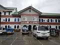
Bambang Municipal Hall
-

Saint Catherine of Siena Parish Church
-

Bambang Gymnasium
-

Bambang (agriculture) Monument
-

Welcome Lion Monument

References
- ↑ "Official City/Municipal 2013 Election Results". Intramuros, Manila, Philippines: Commission on Elections (COMELEC). 11 September 2013. Retrieved 19 December 2013.
- 1 2 "Province: NUEVA VIZCAYA". PSGC Interactive. Makati City, Philippines: National Statistical Coordination Board. Archived from the original on 1 January 1970. Retrieved 19 December 2013.
- 1 2 3 "Total Population by Province, City, Municipality and Barangay: as of May 1, 2010" (PDF). 2010 Census of Population and Housing. National Statistics Office. Archived from the original (PDF) on 14 November 2013. Retrieved 19 December 2013.
- ↑ "Archived copy". Archived from the original on 13 May 2012. Retrieved 16 June 2012. |title: Bambang, Nueva Vizcaya Development
External links
| Wikimedia Commons has media related to Bambang, Nueva Vizcaya. |
- The Valley Journal - Weekly Community Newspaper Circulating in Cagayan Valley!
- News From Bambang
- Philippine Standard Geographic Code
- Philippine Census Information
- Local Governance Performance Management System
- Nueva Vizcaya
- itlogMaalat – Local Artist Based in Bambang
 |
Ambaguio / Bayombong | Quezon | | |
| Kayapa | |
Kasibu | ||
| ||||
| | ||||
| Aritao / Dupax del Sur | Dupax del Norte |
Bayombong (capital) | |
| Municipalities | |
| Barangays | |