Aylett, Virginia
| Aylett | |
|---|---|
| Unincorporated community | |
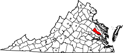
 Aylett  Aylett Location within the Commonwealth of Virginia | |
| Coordinates: 37°47′9″N 77°6′17″W / 37.78583°N 77.10472°WCoordinates: 37°47′9″N 77°6′17″W / 37.78583°N 77.10472°W | |
| Country | United States |
| State | Virginia |
| County | King William |
| Time zone | Eastern (EST) (UTC-5) |
| • Summer (DST) | EDT (UTC-4) |
Aylett is an unincorporated community in King William County, Virginia, United States.[1] It is located where Virginia State Route 360 crosses the Mattaponi River. William Aylett and his family had several prominent warehouses and mills in the area.
Formerly, Todd's Bridge (no longer in existence) (aka Todd's) was north of Aylett. Todd's and Aylett were both mentioned in Tobacco Inspection Act of 1730 legislation as a location for a public tobacco inspection warehouse.
Later, in 1781, Todd's Bridge provided crossing of the Mattaponi as a part of the Washington–Rochambeau Revolutionary Route [2]
Burlington, Holly Hill, Roseville Plantation, and Zoar are listed on the National Register of Historic Places.[3]
See also
References
- ↑ U.S. Geological Survey Geographic Names Information System: Aylett, Virginia
- ↑ http://xenophongroup.com/mcjoynt/W-RRREV.htm "After Bolling Green, the route proceeded southeast, and crossed the Mattaponi river at Todds' Bridge [no longer in existence, but located north of locations identified with ‘Aylett' on the southern side of the river]. "
- ↑ National Park Service (2010-07-09). "National Register Information System". National Register of Historic Places. National Park Service.