Arteche, Eastern Samar
| Arteche | |
|---|---|
| Municipality | |
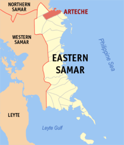 Map of Northern Samar with Arteche highlighted | |
.svg.png) Arteche Location within the Philippines | |
| Coordinates: 12°16′N 125°22′E / 12.27°N 125.37°ECoordinates: 12°16′N 125°22′E / 12.27°N 125.37°E | |
| Country | Philippines |
| Region | Eastern Visayas (Region VIII) |
| Province | Eastern Samar |
| Congr. district | Lone district of E. Samar |
| Established | 1950 |
| Barangays | 20 |
| Government[1] | |
| • Mayor | Roland Boie Evardone |
| Area[2] | |
| • Total | 169.82 km2 (65.57 sq mi) |
| Population (2015 census)[3] | |
| • Total | 16,026 |
| • Density | 94/km2 (240/sq mi) |
| Time zone | PST (UTC+8) |
| ZIP code | 6822 |
| Dialing code | +63 (0)55 |
Arteche is a third class municipality in the province of Eastern Samar, Philippines. In the southeast, it is bounded by Oras, to the south by San Policarpo. To the north, it is bounded by Pacific Ocean and in the north-west by Lapinig. According to the 2015 census, it has a population of 16,026 people.[3]
History
Arteche was created in 1950 from the barrios of San Ramon, Carapdapan, Beri, Tangbo, Catumsan, Bego, Concepcion, Casidman, Tawagan, and Tibalawon of the Municipality of Oras.[4]
Barangays
Arteche is politically subdivided into 20 barangays.[2]
- Aguinaldo
- Balud (Pob.)
- Bato (San Luis)
- Beri
- Bigo
- Buenavista
- Cagsalay
- Campacion
- Carapdapan
- Casidman
- Catumsan
- Central (Pob.)
- Concepcion
- Garden (Pob.)
- Inayawan
- Macarthur
- Rawis (Pob.)
- Tangbo
- Tawagan
- Tebalawon
Demographics
| Population census of Arteche | ||
|---|---|---|
| Year | Pop. | ±% p.a. |
| 1990 | 11,245 | — |
| 1995 | 12,538 | +2.06% |
| 2000 | 13,024 | +0.82% |
| 2007 | 14,354 | +1.35% |
| 2010 | 15,164 | +2.02% |
| 2015 | 16,026 | +1.06% |
| Source: Philippine Statistics Authority[3][5][6] | ||
References
- ↑ "Municipalities". Quezon City, Philippines: Department of the Interior and Local Government. Archived from the original on 25 January 2013. Retrieved 22 April 2013.
- 1 2 "Province: Eastern Samar". PSGC Interactive. Makati City, Philippines: National Statistical Coordination Board. Retrieved 22 April 2013.
- 1 2 3 "Region VIII (EASTERN VISAYAS)". Census of Population (2015): Total Population by Province, City, Municipality and Barangay (Report). PSA. Retrieved 20 June 2016.
- ↑ "An act creating the barrio of Arteche, province of Samar into a municipality". LawPH.com. Retrieved 2011-04-09.
- ↑ "Total Population by Province, City, Municipality and Barangay: as of May 1, 2010" (PDF). 2010 Census of Population and Housing. National Statistics Office. Archived from the original (PDF) on 20 March 2013. Retrieved 22 April 2013.
- ↑ "Province of Eastern Samar". Municipality Population Data. LWUA Research Division. Retrieved 20 August 2013.
External links
- Philippine Standard Geographic Code
- Philippine Census Information
- Local Governance Performance Management System
 |
Jipapad | Lapinig, Northern Samar | Philippine Sea | |
| |
||||
| ||||
| | ||||
| Maslog | Oras | San Policarpo |
Borongan (capital) | |
| Municipalities | |
| Component city | |
This article is issued from Wikipedia - version of the 10/18/2016. The text is available under the Creative Commons Attribution/Share Alike but additional terms may apply for the media files.