Arrien
| Arrien | |
|---|---|
|
Countryside at Arrien | |
 Arrien | |
|
Location within Nouvelle-Aquitaine region  Arrien | |
| Coordinates: 43°18′41″N 0°09′15″W / 43.3114°N 0.1542°WCoordinates: 43°18′41″N 0°09′15″W / 43.3114°N 0.1542°W | |
| Country | France |
| Region | Nouvelle-Aquitaine |
| Department | Pyrénées-Atlantiques |
| Arrondissement | Pau |
| Canton | Morlaàs |
| Intercommunality | Pays de Morlaàs |
| Government | |
| • Mayor (2008–2020) | Martine Loustau |
| Area1 | 4.46 km2 (1.72 sq mi) |
| Population (2010)2 | 154 |
| • Density | 35/km2 (89/sq mi) |
| Time zone | CET (UTC+1) |
| • Summer (DST) | CEST (UTC+2) |
| INSEE/Postal code | 64053 / 64420 |
| Elevation |
312–389 m (1,024–1,276 ft) (avg. 374 m or 1,227 ft) |
|
1 French Land Register data, which excludes lakes, ponds, glaciers > 1 km² (0.386 sq mi or 247 acres) and river estuaries. 2 Population without double counting: residents of multiple communes (e.g., students and military personnel) only counted once. | |
.JPG)
Arrien (Occitan: Arrien) is a French commune in the Pyrénées-Atlantiques department in the Nouvelle-Aquitaine region of south-western France.
Geography
Arrien is located some 18 km east by north-east of Pau and 5 km west of Séron. Access to the commune is by road D42 from Sedzère in the north passing through the heart of the commune east of the village and continuing south to Eslourenties-Daban. The D145 also comes from Baleix in the north and joins the D42 in the commune then continues south-west to Lourenties. Access to the village (Town Hall) is by the Chemin de l'Eglise going west from the D42 and by other local roads. Apart from some patches of forest on the western border the commune is entirely farmland.[1]
The Canne stream forms the southern border of the commune joining the Gabas at the south-western corner which in turn forms most of the western border of the commune flowing north-west then north eventually joining the Adour near Toulouzette. The Poundets stream forms the eastern border of the commune and flows north to join the Petit Lees near Lombia.
Places and Hamlets
- Canton
- Cazaux
- Claria
- La Croix d'Arrien
- Fontaine Saint-Jean
- Peret
- La Picharotte
- Poulot
- Pouygarou
- Sarthou
Neighbouring communes and villages
 |
Sedzère | Lombia | | |
| Espéchède | |
Saubole | ||
| ||||
| | ||||
| Andoins | Lourenties | Eslourenties-Daban |
Toponymy
Its name in béarnais is Arrien.
Michel Grosclaude indicated that the origin of the name is obscure and mentioned the possibility of the name of a former owner Ariee.[2]
The following table details the origins of the commune name.
| Name | Spelling | Date | Source | Page | Origin | Description |
|---|---|---|---|---|---|---|
| Arrien | Arien | 1385 | Raymond | Census | Village | |
| Rien | 1536 | Raymond | Eslourenties | |||
| Saint-Jean d'Arien | 18th century | Raymond | Empire | |||
| Arrien | 1750 | Cassini | ||||
| Arricu | 1793 | Ldh/EHESS/Cassini |
Sources:
- Raymond: Topographic Dictionary of the Department of Basses-Pyrenees, 1863, on the page numbers indicated in the table. (French)[3]
- Cassini: Cassini Map from 1750[4]
- Ldh/EHESS/Cassini: Ldh/EHESS/Cassini database (French)
Origins:
- Census: Census of Béarn[5]
- Eslourenties: Census of Eslourenties[6]
- Empire: Archives of the Empire, K 779, No. 12 (French)
History
Paul Raymond noted that the commune had a Lay Abbey, vassal of the Viscounts of Béarn. In 1385 Arrien had 5 fires and depended on the bailiwick of Pau. The church depended on the Abbey of Saint-Sigismund at Orthez.[3]
The Saint-Jean fountain is known for its healing powers of varicose ulcers and eye diseases and has attracted many pilgrims since the 12th century.[7]
The commune was part of the Archdeaconry of Vic-Bilh, which depended on the Bishop of Lescar. Lembeye was the chief town.[8]
Administration
List of Successive Mayors[9]
| From | To | Name | Party | Position |
|---|---|---|---|---|
| 1923 | 1929 | Dominique Pédedieu | ||
| 1929 | 1944 | Joseph Canton | ||
| 1944 | 1946 | Joseph Lahon | ||
| 1947 | 1959 | Joseph Canton | ||
| 1959 | 1983 | Pierre Canton | ||
| 1983 | 1995 | André Cazalis | ||
| 1995 | 2001 | Jean Canton | ||
| 2001 | 2005 | Jean Louis Cazalis | ||
| 2005 | 2008 | Bernard Joan | ||
| 2008 | 2020 | Martine Loustau |
(Not all data is known)
Inter-communality
The commune is part of four inter-communal structures:
- the Community of communes of Pays de Morlaàs;
- the AEP association of Luy and Gabas;
- the Energy association of Pyrénées-Atlantiques;
- the inter-communal association for the construction of the Soumoulou rescue centre;
Demography
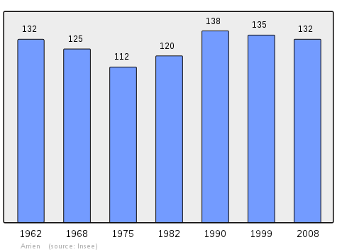
In 2010 the commune had 154 inhabitants. The evolution of the number of inhabitants is known from the population censuses conducted in the commune since 1793. From the 21st century, a census of communes with fewer than 10,000 inhabitants is held every five years, unlike larger towns that have a sample survey every year.[Note 1]
| 1793 | 1800 | 1806 | 1821 | 1831 | 1836 | 1841 | 1846 | 1851 |
|---|---|---|---|---|---|---|---|---|
| 209 | 201 | 191 | 231 | 252 | 239 | 265 | 269 | 270 |
| 1856 | 1861 | 1866 | 1872 | 1876 | 1881 | 1886 | 1891 | 1896 |
|---|---|---|---|---|---|---|---|---|
| 272 | 308 | 281 | 250 | 241 | 235 | 208 | 190 | 193 |
| 1901 | 1906 | 1911 | 1921 | 1926 | 1931 | 1936 | 1946 | 1954 |
|---|---|---|---|---|---|---|---|---|
| 189 | 218 | 187 | 161 | 180 | 163 | 154 | 135 | 135 |
| 1962 | 1968 | 1975 | 1982 | 1990 | 1999 | 2006 | 2010 | - |
|---|---|---|---|---|---|---|---|---|
| 132 | 125 | 112 | 120 | 138 | 135 | 119 | 154 | - |
Sources : Ldh/EHESS/Cassini until 1962, INSEE database from 1968 (population without double counting and municipal population from 2006)
Culture and Heritage
Civil Heritage
There are two registrations of historical monuments for Arrien:
- Houses and Farms
 [10]
[10] - The former Chateau of Arrien (19th century)..[11] The original chateau was sold in 1730 and converted to a presbytery. The building was sold by the commune in 1975. It is shown on the Cassini Map as a "chateau".
Religious Heritage
The Parish Church of Saint John the Baptist (19th century)![]() is registered as an historical monument.[12] The church contains several items that are registered as historical objects:
is registered as an historical monument.[12] The church contains several items that are registered as historical objects:
- The Furniture in the Church
 [13]
[13] - A Sunburst Monstrance (19th century)[14]
- A Processional Cross (17th century)[15]
- A Processional banner (19th century)[16]
- Church Picture Gallery
-
.JPG)
The Church over the fields
-
_vue_2.JPG)
The Church from the road
-
_vue_4.JPG)
The church through the trees
-
_vue_3.JPG)
The church
See also
Notes
- ↑ At the beginning of the 21st century, the methods of identification have been modified by Law No. 2002-276 of 27 February 2002, the so-called "law of local democracy" and in particular Title V "census operations" allows, after a transitional period running from 2004 to 2008, the annual publication of the legal population of the different French administrative districts. For communes with a population greater than 10,000 inhabitants, a sample survey is conducted annually, the entire territory of these communes is taken into account at the end of the period of five years. The first "legal population" after 1999 under this new law came into force on 1 January 2009 and was based on the census of 2006.
References
- ↑ Google Maps
- ↑ Michel Grosclaude, Toponymic Dictionary of communes, Béarn, Edicions reclams & Édition Cairn - 2006, 416 pages, ISBN 2 35068 005 3 (French)
- 1 2 Topographic Dictionary of the Department of Basses-Pyrenees, Paul Raymond, Imprimerie nationale, 1863, Digitised from Lyon Public Library 15 June 2011 (French)
- ↑ Cassini Map 1750 – Arrien
- ↑ Manuscript from the 14th century - Departmental Archives of Pyrénées-Atlantiques (French)
- ↑ Census of Eslourenties, B. 807, f° 17 (French)
- ↑ Brigitte Jobbé-Duval, Dictionary of place names - Pyrénées-Atlantiques, 2009, Archives and Culture, ISBN 978-2-35077-151-9 (French)
- ↑ Topographic Dictionary of the Department of Basses-Pyrenees, Paul Raymond, Imprimerie nationale, 1863, Digitised from Lyon Public Library 15 June 2011, p. 174 (French)
- ↑ List of Mayors of France (French)
- ↑ Ministry of Culture, Mérimée IA00026893 Houses and Farms (French)
- ↑ Ministry of Culture, Mérimée IA00026895 Chateau of Arrien (French)
- ↑ Ministry of Culture, Mérimée IA00026894 Parish Church of Saint John the Baptist (French)
- ↑ Ministry of Culture, Palissy IM64000478 Furniture in the Church (French)
- ↑ Ministry of Culture, Palissy IM64000477 Sunburst Monstrance (French)
- ↑ Ministry of Culture, Palissy IM64000476 Processional Cross (French)
- ↑ Ministry of Culture, Palissy IM64000475 Processional Banner (French)
External links
- Arrien on Lion1906
- Arrien on the 1750 Cassini Map
- Arrien on the INSEE website (French)
- INSEE (French)
| Wikimedia Commons has media related to Arrien (Pyrénées-Atlantiques). |