Barzun, Pyrénées-Atlantiques
| Barzun | |
|---|---|
|
The Town hall | |
 Barzun | |
|
Location within Nouvelle-Aquitaine region  Barzun | |
| Coordinates: 43°12′53″N 0°07′41″W / 43.2147°N 0.1281°WCoordinates: 43°12′53″N 0°07′41″W / 43.2147°N 0.1281°W | |
| Country | France |
| Region | Nouvelle-Aquitaine |
| Department | Pyrénées-Atlantiques |
| Arrondissement | Pau |
| Canton | Pontacq |
| Intercommunality | Ousse-Gabas |
| Government | |
| • Mayor (2008–2020) | Maurice Minvielle |
| Area1 | 8.19 km2 (3.16 sq mi) |
| Population (2010)2 | 595 |
| • Density | 73/km2 (190/sq mi) |
| Time zone | CET (UTC+1) |
| • Summer (DST) | CEST (UTC+2) |
| INSEE/Postal code | 64097 / 64530 |
| Elevation |
323–435 m (1,060–1,427 ft) (avg. 388 m or 1,273 ft) |
|
1 French Land Register data, which excludes lakes, ponds, glaciers > 1 km² (0.386 sq mi or 247 acres) and river estuaries. 2 Population without double counting: residents of multiple communes (e.g., students and military personnel) only counted once. | |

Barzun is a commune in the Pyrénées-Atlantiques department in the Nouvelle-Aquitaine region of south-western France.[1]
The inhabitants of the commune are known as Barzunais or Barzunaises.[2]
Geography
Barzun is located some 20 km east by south-east of Pau and 15 km north-west of Lourdes. Access to the commune is by the D940 road from Espoey in the north-west which passes through the commune just west of the village and continues south to Lamarque-Pontacq. The D640 comes from Livron in the north and passes through the village continuing to Pontacq in the south. The D642 and the D418 connect the D940 to the village. The D42 passes through the eastern tip of the commune. The commune is all farmland except for a belt of forest east of and parallel to the Ruisseau de l'Ousse.[3][4]
The Ruisseau de l'Ousse flows through the commune and the village from south-east to north and continues north to join the Gave de Pau at Pau. The Oussère river flows parallel to the Ruisseau de l'Ousse west of the village until they join north of the commune. The Sausse forms the western border of the commune as it flows north to join the Ourrou north-west of the commune. The Hoursoumou and the Ruisseau du Goua de Michou flow parallel to each other north through the east of the commune continuing to join the Gabas Lake at Luquet.[3][4]
Mapping
A list of online mapping systems can be displayed by clicking on the coordinates (latitude and longitude) in the top right hand corner of this article.
Neighbouring communes and villages
 |
Hours | Livron | | |
| Lagos | |
|||
| ||||
| | ||||
| Labatmale | Lamarque-Pontacq | Pontacq |
Places and hamlets[4]
- Arribarrouy
- Balagué
- Batailles
- Bédat
- Bédat et Sarrailh
- Boyrie
- Capblan
- Cazaillet
- Cazala (barn)
- Las Cordes
- La Débèze
- Goua (bridge)
- Grada (barn)
- Hourcaspy
- Hourmiau
- Hourq Mayou et Espélague
- Labourdette
- Lanas
- Lapalangue (bridge)
- Larbiouze (barn)
- Larroutis
- Layrisse (barn)
- Lupié Thén[5]
- Moulat
- Nargasse (barn)
- Pardimène (mill)
- Pène
- Pistoulet (barn)
- Le Poublan
- Ramounet
- Técous et Labie
- Tisnères (barn)
Toponymy
Michel Grosclaude said that the name probably comes from the Latin anthroponym Barisius with the suffix -unum.[6]
The following table details the origins of the commune name and other names in the commune.
| Name | Spelling | Date | Source | Page | Origin | Description |
|---|---|---|---|---|---|---|
| Barzun | Barzunum | 1286 | Raymond | Chapter | Village | |
| Barsuu | 1385 | Grosclaude | Census | |||
| Barsun | 1402 | Raymond | Census | |||
| Barssun | 1538 | Raymond | Reformation | |||
| Barfun | 1750 | Cassini1 | ||||
| Barjun | 1790 | Cassini2 | ||||
| Lupié Thén | Le Lupié | 1863 | Raymond | Hamlet | ||
| Les Mouras | Les Mouras | 1863 | Raymond | Place | ||
| Le Pardiacq | Le Pardiacq | 1863 | Raymond | Place | ||
| La Peyrade | La Peyrade | 1863 | Raymond | Place |
Sources:
- Raymond: Topographic Dictionary of the Department of Basses-Pyrenees, 1863, on the page numbers indicated in the table. (French)[5]
- Grosclaude: Toponymic Dictionary of communes, Béarn, 2006 (French)[6]
- Cassini1: 1750 Cassini Map[7]
- Cassini2: 1790 Cassini Map[8]
Origins:
- Chapter: Titles of the Chapter of Béarn[9]
- Census: Census of Béarn[10]
- Reformation: Reformation of Béarn[11]
History
Paul Raymond noted of page 22 of his 1863 dictionary that Barzun had 13 fires in 1385 and depended on the bailiwick of Pau.
In the 18th century Barzun was the chief town for the notary of Rivière-Ousse which comprised Artigueloutan, Barzun, Espoey, Gomer, Hours, Lée, Livron, Louboey, Lucgarier, Nousty, Ousse, Sendets, and Soumoulou.[5]
Administration
| From | To | Name | Party | Position |
|---|---|---|---|---|
| 1995 | 2001 | Alfred Prat-Bernachot | ||
| 2001 | 2020 | Maurice Minvielle |
(Not all data is known)
Inter-communality
The commune is part of four inter-communal structures:
- the Community of communes of Ousse-Gabas;
- the water management association of the Ousse basin
- the Energy association of Pyrénées-Atlantiques;
- the inter-communal association for water and sanitation in the Ousse valley;
Education
The commune has a public primary school.[13]
Demography
In 2010 the commune had 595 inhabitants. The evolution of the number of inhabitants is known from the population censuses conducted in the commune since 1793. From the 21st century, a census of communes with fewer than 10,000 inhabitants is held every five years, unlike larger communes that have a sample survey every year.[Note 1]
| 1793 | 1800 | 1806 | 1821 | 1831 | 1836 | 1841 | 1846 | 1851 |
|---|---|---|---|---|---|---|---|---|
| 505 | 525 | 555 | 607 | 639 | 680 | 717 | 697 | 702 |
| 1856 | 1861 | 1866 | 1872 | 1876 | 1881 | 1886 | 1891 | 1896 |
|---|---|---|---|---|---|---|---|---|
| 691 | 660 | 657 | 648 | 630 | 612 | 570 | 547 | 521 |
| 1901 | 1906 | 1911 | 1921 | 1926 | 1931 | 1936 | 1946 | 1954 |
|---|---|---|---|---|---|---|---|---|
| 519 | 516 | 502 | 425 | 411 | 409 | 394 | 347 | 399 |
| 1962 | 1968 | 1975 | 1982 | 1990 | 1999 | 2006 | 2010 | - |
|---|---|---|---|---|---|---|---|---|
| 409 | 365 | 363 | 401 | 455 | 464 | 569 | 595 | - |
Sources : Ldh/EHESS/Cassini until 1962, INSEE database from 1968 (population without double counting and municipal population from 2006)


Economy
The commune is part of the Appellation d'origine contrôlée of Ossau-iraty
Culture and heritage

Religious heritage
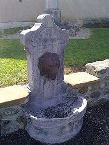
The Parish Church of Saint Vincent Diacre (1854)![]() is registered as an historical monument.[14]
is registered as an historical monument.[14]
Notable people linked to the commune
- Louis Pardimène, born on 15 July 1880 in Barzun, son of Pierre and Marie Ribes, soldier in the 83rd Infantry Regiment who was shot as an example on 7 January 1915 at Châlons-sur-Marne.
- Pierre-Marie Théas, born in 1894 at Barzun and died in 1977, was a French Catholic religious, Bishop of Montauban then of the Diocese of Tarbes-et-Lourdes.
- Gaëtan Paletou, Racing driver who participated in the 24 Hours of Le Mans in 2015.
See also
Notes and references
Notes
- ↑ At the beginning of the 21st century, the methods of identification have been modified by Law No. 2002-276 of 27 February 2002, the so-called "law of local democracy" and in particular Title V "census operations" allows, after a transitional period running from 2004 to 2008, the annual publication of the legal population of the different French administrative districts. For communes with a population greater than 10,000 inhabitants, a sample survey is conducted annually and the entire territory of these communes is taken into account at the end of the period of five years. The first "legal population" after 1999 under this new law came into force on 1 January 2009 and was based on the census of 2006.
References
- ↑ Barzun on Lion1906
- ↑ Inhabitants of Pyrénées-Atlantiques (French)
- 1 2 3 Barzun on Google Maps
- 1 2 3 Barzun on the Géoportail from National Geographic Institute (IGN) website (French)
- 1 2 3 Topographic Dictionary of the Department of Basses-Pyrenees, Paul Raymond, Imprimerie nationale, 1863, Digitised from Lyon Public Library 15 June 2011 (French)
- 1 2 Michel Grosclaude, Toponymic Dictionary of communes, Béarn, Edicions reclams & Édition Cairn - 2006, 416 pages, ISBN 2-35068-005-3(French)
- ↑ Barfun on the 1750 Cassini Map
- ↑ Barjun on the 1790 Cassini Map
- ↑ Titles of the Viscounts of Béarn in the Departmental Archives of Pyrénées-Atlantiques (French)
- ↑ Manuscript from the 14th century - Departmental Archives of Pyrénées-Atlantiques (French)
- ↑ Manuscript from the 16th to 18th centuries - Departmental Archives of Pyrénées-Atlantiques (French)
- ↑ List of Mayors of France (French)
- ↑ Schools in Barzun (French)
- ↑ Ministry of Culture, Mérimée IA64000647 Parish Church of Saint Vincent Diacre (French)
| Wikimedia Commons has media related to Barzun. |